| ©The Archaeological Settlements of Turkey - TAY Project | ||||||
|
|
||||||
Arpalik Tepe |
||||||
|
|
||||||
| Ages | Maps | Photos | ||||
| EBA IA |
 |
 |
||||
|
|
||||||
|
Type:
|
Mound | |||||
|
Altitude:
|
10 m | |||||
|
Diameter:
|
m- Direction: | |||||
|
|
||||||
|
Region:
|
Marmara | |||||
|
Province:
|
Edirne | |||||
|
District:
|
Ipsala | |||||
|
Village:
|
Tevfikiye | |||||
|
|
||||||
|
Destruction :
|
Agriculture - Highways, roads, bridges etc. - Attention | |||||
|
|
||||||
|
TAYEx:
|
Visited - 15/6/2000 | |||||
|
|
||||||
|
Registration State:
|
For detailed registration information please refer to Turkish pages. | |||||
 |
||||||
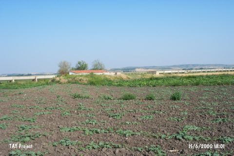
| Location: It is located 1 km northeast of the Tevfikiye village; about 22 km northeast of the Ipsala District of the Edirne Province. It is also known as Arpa Tepe by the locals. |
| Geography and Environment: The settlement which lays under the rice fields today was flattened for cultivating purposes. The cultural deposit has been spread onto a wide terrain. It has been severely damaged and as a result of this destruction its height and dimensions are uncertain. There is an irrigation channel to its east and a tractor road that runs parallel to the channel. The building of Agriculture Cooperative made of mud bricks lies to the east of the road. |
| Destruction Details: A large amount of soil was removed from the mound and its surface was leveled. The results of the destruction can clearly be observed in the western part where a half moon shaped section was formed. A channel was dug into the middle of the highest area of the settlement [TAYEx 15.6.2000]. |