|
©The Archaeological Settlements of Turkey - TAY Project
|
|
|
|
|
|
Arpalik Tepe |
|
|
For site maps and drawings please click on the picture...  |
For photographs please click on the photo... 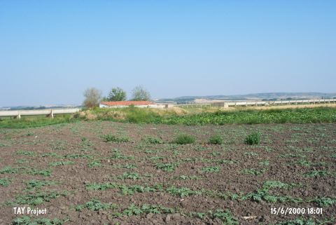 |
|
Type:
|
Mound |
|
Altitude:
|
10 m |
|
Region:
|
Marmara |
|
Province:
|
Edirne |
|
District:
|
Ipsala |
|
Village:
|
Tevfikiye |
|
Investigation Method:
|
Survey |
|
Period:
|
|
|
|
|
 |
|
| It lies about 1 km northeast of the Tevfikiye Village, approximately 22 km northeast of the Ipsala District in Edirne. Completely obscured by the paddy fields, the settlement was flattened for cultivation purposes and the deposit was spreaded onto a wide terrain. A severe destruction has been observed. It was discovered during the Edirne Survey conducted by B. Erdogu in 1997. Vast majority of the material collected from the surface belongs to the Classical Period. In addition to that, EBA material and sherds of "Maslidere" type of pottery from the Middle Chalcolithic Age were collected. |
| Location: It is located 1 km northeast of the Tevfikiye village; about 22 km northeast of the Ipsala District of the Edirne Province. It is also known as Arpa Tepe by the locals. |
| Geography and Environment: The settlement which lays under the rice fields today was flattened for cultivating purposes. The cultural deposit has been spread onto a wide terrain. It has been severely damaged and as a result of this destruction its height and dimensions are uncertain. There is an irrigation channel to its east and a tractor road that runs parallel to the channel. The building of Agriculture Cooperative made of mud bricks lies to the east of the road. |
| History: |
| Research and Excavation: |
| Stratigraphy: |
| Small Finds: |
| Remains: |
| Interpretation and Dating: |