| ©The Archaeological Settlements of Turkey - TAY Project | ||||||
|
|
||||||
Küllüoba |
||||||
|
|
||||||
| Ages | Maps | Photos | ||||
| Chalcolithic EBA |
 |
 |
||||
|
|
||||||
|
Type:
|
Mound | |||||
|
Altitude:
|
915 m | |||||
|
Diameter:
|
m- Direction: | |||||
|
|
||||||
|
Region:
|
Central Anatolia | |||||
|
Province:
|
Eskisehir | |||||
|
District:
|
Seyitgazi | |||||
|
Village:
|
Yenikent | |||||
|
|
||||||
|
|
||||||
|
|
||||||
|
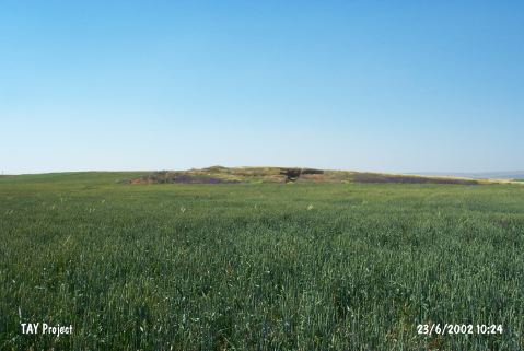
TAYEx:
|
Visited - 23/6/2002 | |||||
|
|
||||||
|
Registration State:
|
Registered For detailed registration information please refer to Turkish pages. | |||||
 |
||||||
| Location: It lies some 1300 m south of the Yenikent Village; 200 m east of the Seyitgazi-Yenikent motorway; 15 km northeast of the Seyitgazi District; about 35 km southeast of the Eskisehir Province. The mound is surrounded by fields. |
| Geography and Environment: It is difficult to notice from a distance since it is a flat mound measuring 9.5-10 m in height and 250x150 m in dimensions. There are three vague small cones on the top hill [Efe 1998:152] which are designated as A; B and C by the excavation team leader while they are referred to as west; east in the publication of the excavation results. |
| Destruction Details: |