|
©The Archaeological Settlements of Turkey - TAY Project
|
|
|
|
|
|
Küllüoba |
|
|
For site maps and drawings please click on the picture...  |
For photographs please click on the photo... 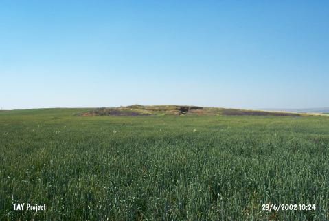 |
|
Type:
|
Mound |
|
Altitude:
|
915 m |
|
Region:
|
Central Anatolia |
|
Province:
|
Eskisehir |
|
District:
|
Seyitgazi |
|
Village:
|
Yenikent |
|
Investigation Method:
|
Excavation |
|
Period:
|
EBA I EBA II EBA III |
|
|
|
 |
|
| Location: It lies some 1300 m south of the Yenikent Village; 200 m east of the Seyitgazi-Yenikent motorway; 15 km northeast of the Seyitgazi District; about 35 km southeast of the Eskisehir Province. The mound is surrounded by fields. |
| Geography and Environment: It is difficult to notice from a distance since it is a flat mound measuring 9.5-10 m in height and 250x150 m in dimensions. There are three vague small cones on the top hill [Efe 1998:152] which are designated as A; B and C by the excavation team leader while they are referred to as west; east in the publication of the excavation results. |
| History: |
| Research and Excavation: The excavations were initiated in 1996 by T. Efe under the direction of the Eskisehir Archaeological Museum; and recently continued under T. Efe (1998). The investigations were mainly concerned with the western and eastern cones of the mound. It takes place in the registered archaeological sites list prepared by Ministry of Culture and Tourism. |
| Stratigraphy: T. Efe claims that the site had been more or less continuously inhabited from the Late Chalcolithic Age to the first quarter of the second millennium BC (1800 BC) depending on the analysis of the sherds recovered during the surface collection. Following levels were determined after the 1996-2000 excavations on the western cone; Level 6: end of Late Chalcolithic Age Levels 5-3: transition from Late Chalcolithic Age to EBA Level 2: EBA I Level 1: beginning of EBA II whereas on the eastern cone; two levels were uncovered; lower one dating to EBA II and upper to EBA III. During the 2003 season; on the hill located in the fields to the southwest of the mound a sounding was conducted. No prehistoric remains were encountered and therefore the work in this area was not continued. The researches in 2005 were intensified on the eastern section of the mound. The excavations were realized on the southern and northern slopes of the east section in order to find out the Yukarisehir plan of EBA II period and to better research the stratification in EBA III period. Additionally trenches were made as possibly it allowed on the same line in south-north direction in the fields on the southeast of the mound. The soundings started in the previous period were resumed inside the trench AR 22 [Efe 2007:72]. It is possible to group EBA Level under four main periods (in ascending order): 1. Late Chalcolithic-EBA Transition Period (3200-3000 BC) 2. EBA I (3000-2700 BC) 3. EBA II (2700-2400 BC) 4. EBA III (2400-2200 BC) [Fidan 2014:18]. |
| Small Finds: Architecture: Only garbage and votive pits belonging to EBA III were uncovered on the eastern small mound/cone. It was noted that those pits destroyed the constructions of lower EBA II level [Efe-Ay-Efe 2001:53]. Finds recovered from those pits contributes to understand the culture of the EBA III settlement demolished by erosion. End of EBA II was also uncovered during the excavation carried out in the eastern cone. Settlement of this level consists of Upper City/Castle and Lower City. The upper city ringed by the fortification walls is entered through two gateways from the east and; probably; from the south. Reconstructed replication of the remains exposes that the settlement doesn't have a rounded shape [Efe-Ay-Efe 2001:draw.2]. A pathway starting from the eastern gate leads to the courtyard in the middle. This courtyard yielded one megaron and two megaron-like side structures resting along both sides of the megaron as well as a complex structure with multi-rooms [Efe-Ay-Efe 2001:draw.3] which is identified as a palace by T. Efe. Four-cornered or trapeze-like houses built; side by side; adjacent to the fortification walls are where the public people lived in [Efe 1999:167-168; draw.2; pic.4; 5; 7] [Efe 2001:pic.5]. This type of settlement plan is called "Anatolian Settlement Plan". Also known from Demircihöyük and Pulur/Sakyol settlements; this plan exposes that the city was designed before it was established. Big building complex; overlooking the settlement; was probably built independently in the open area functioning as a square or a big courtyard. Structure; 23 m long; located in the middle has a typical megaron plan with its antes [Efe 2000a:120] [Efe 2001:109]. Its entrance faces the eastern gate. Inside the building; there is a platform built of vertically placed mudbricks and a hearth observed to have wooden columns around it. To the south; megaron-like structure with multi-rooms ends up in the eastern part. Entrance to this structure is through the big room of the megaron. Symmetrical construction on the north (north side) is also entered through the megaron. All constructions have individual walls. Stone paved apprentice of the megaron functions like a front door of the construction. Small unit next to this anta is considered to be built probably for stairs going up to the roof. The present appearance of the building resembles the constructions of Troy I and Poliochni; and probably it is a public/administrative building or a building resided by the ruler of the city. All mudbrick walls of the three structures built side by side have thick plasters. It is also observed that the plaster was whitewashed. Public houses surrounding the courtyard where this structure is located were uncovered in a lower altitude extending to the east and south. T. Efe claims that they were built in a radial plan oriented to the courtyard and the village was entered from a gate on the eastern side. The 1999 excavation yielded a corner of another public building centrally located in the courtyard. It was revealed that this settlement was also fortified [Efe 2001:110]. Rear walls of the houses facing the courtyard lean on these fortifications. [Efe 2001:109]. The 1997 excavation yielded a stone foundation of 2 m thick dating to the end of EBA I followed by a thick fire level [Efe 1999:169]. The 2001 season focused on determining the plan of the upper town dating to EBA II. The plan of the eastern gate was almost completely revealed and it was understood that the two towers on either sides of the gate were not arranged symmetrically. The door includes at least three main phases. The single roomed building to the west of the gate can only be reached through the courtyard. From the courtyard first a small rectangular building is reached and from this building by turning around the northern room through a corridor; three rooms to the north. It was determined that these structures underwent a massive fire. In the rubble and on the floor of the building on the corner were encountered in situ finds that mostly consist of ceramics. On the corner leaning to the wall is a hearth. Numerous white layers were found to the north of the courtyard [Efe 2003a:462-464]. Mudbrick walls that might belong one of the main doors of the castle uncovered during 2005 season excavations; which were carried out with the aim of finding the extension of the city wall at the area called Upper Town on the northern slope. As a result of the excavations on the west part of the southern slope; plan of Complex II was completed. It was understood that the complex was used for a long period with various building levels and renovations. There are three megarons in the complex. The big megaron at the southern part has only two rooms at the early phases and except the hearths there are almost no other architectural elements or in situ finds. But the units belonging to the building called annex contain silos; ovens; potsherds; ground stones; bone and stone artifacts. The long trapezoid room at the center is thought to be used as a light well because of the absent architectural elements and floors [Efe 2006:23]. Excavation carried out in the square U9 on the northwestern cone has laid out a building with mudbrick walls in EBA I level; the transition period from the Late Chalcolithic Age to EBA [Efe 1999:166]. In 2001; houses filled with red soil were recovered. On the corner of onu of these rooms were found thin walls that may belong to a silo. The walls of the house were preserved up to 2 m and have holes that may be for wooden beams. On one of the walls is a well preserved door [Efe 2003a:462]. There are unattached houses and insulas at the Lower Town. The megaron-house uncovered at this area shows that it is a familiar plan for the region since EBA I period [Efe 2006:23]. During the researches on the Yukarisehir EBA II fortifications on the northern slope of the mound conic in 2005 excavations it was observed that the upper fortification was constructed with smaller stones. The fortification connects with the tower-like profile in the western part. A rampage was built with larger stones on the part closer to the tower of the fortification. That rampage coincides with back part of the house which connects with the tower in the south direction. Stones were taken away from both sides of the house at the corners where it is connected with the fortification. The destruction covers all the way into the early phase walls' stones [Efe 2007:72-73]. A wall was unearthed constructed with large stones; that extends in the east-west direction on the southern profile; during the clearing of another destruction which also cuts a kiln base from EBA III period [Efe 2007:73]. Following the soft ash filling that leads to the bottom of the EBA III wall; the edge of a mud wall was coincided [Efe 2007:74]. The well preserved building remain that contains at least four rooms; constructed with mud; is dating to Late EBA III period [Efe 2007:75]. The plan of Complex II on the west side of the southern slope was also completely unearthed in 2005. The external borders of this large; independent complex that consists of rectangular rooms; does not give out a real rectangular plan. The complex was made stepwise narrow on its northern part; and it measures 31 m in east-west; and 22 m in north-south direction. The three rooms that are lined up along its western façade face westwards; and the four adjacent rooms on the eastern side are facing the east direction. Almost all the rooms have independent rooms. Some rooms contain passages from one room to the other. This plan makes the building look similar to an insula. The restoration phases of the complex in whole; shows that it was used for a long period of time. Large; flat stones were placed underneath the wall foundations [Efe 2007:76]. The long building on the southern part of the complex exhibits a semi typical megaron plan. The building which consists of four phases was built on three terraces on a gradually towards the west descending slope. There is a three phase stone rampage on the western entrance. After the removal of the phase that was revealed in 2004; the lower rampage was unearthed. This rampage possibly was extended until the separation wall inside the shed. The stone pile in front of the entrance at the separation wall; supports this hypothesis. The small silo carved into the ground; on the northern corner of the shed; was possibly made at the upper phase. The contemporary separation wall; as well as the early rampage were unearthed after the removal of the upper phase stones of the separation wall behind the shed. There is soil filling in between the two walls. Wooden remains were revealed on the three flat stones of the entrance threshold near the separation wall center [Efe 2007:76-77]. After the removal of the modern destruction on the west of the central room; the separation wall's preserved bottom part delimiting the room at its western section was observed; which was dug during the previous years. The central room measured 8.5 m long [Efe 2007:77]. The two megarons towards the north of the Big Megaron were named "Central and Northern Megaron" and both are facing westwards. There were two punctures on the shed of the Central Megaron that were built for poles. A part of the shed was partially closed on the southern side by rocks; to support the roof. There is an additional gate providing the traffic flow between the Big Megaron's first room and the shed of the Central Megaron. There are large silos with round walls on the western corners of the room on both sides of the entrance with the flat threshold of the large room behind the shed. There is another rectangular silo divided into two equal cells located behind the room [Efe 2007:78]. It is found that the stone pavement that was previously unearthed along the northern anta which is the same length as the southern section of the Northern Megaron that was previously excavated; did not continue towards the north direction. Instead; there is clearly a floor found at this section. There are two small rooms that were possibly used as silos in the rear part of the megaron [Efe 2007:79]. Dense ancient and modern destruction was observed in all the trenches [Efe 2007:83]. As a result of the 2006 excavations most of the settlement plan of the fortress was revealed. In order to complete the plan and unearth the earlier phases the researches at the Eastern Gate restarted. The entrance room was delimited by a separation wall which constitutes an entrance at the south. Following the entrance room in the south the front room was possibly accessed through that gate. Another room or a courtyard was accessed which possibly gave access to the upper town through the gate located inside the western wall that delimited the entrance room. Additionally a long and narrow room was found in the plan of a corridor; which extends alongside the eastern wall of the entrance which is accessed from the entrance room. The northern room contains a thick floor cover which extends alongside the eastern profile; which was partially unearthed. The fortification and the adjacent residences were partially unearthed on the southern slope of the eastern section of the mound. In the section where the square plans of AD 20; AD 21; AE 21; and AF 21 are found another building complex denominated as "Complex III" was revealed; which contains three buildings. At this complex the main building with the megaron plan makes a profile at the façade of the Complex as it is the case in Complex I. There are no internal architectural elements were observed worth mentioning. It is not certain whether the three building complexes had different functions or not. The researches where the building phases and plan of Complex II revealed important results; started with the areas which were never excavated before. As it was the case in the previous years finds were revealed in situ on the floors of the upper phases. After the adobe walls and the foundation stones of this phase were removed the adobe walls of the earlier phase were revealed. An "L" shaped corridor was constructed to the east of the building which could have served as "lighting well" in the center of the complex; One end of this corridor is connected to the lighting well and the other end with the outside access on the eastern wall. This way; the eastern street was accessed through two gates to the "L" shaped corridor and then to the Megaron hall and the lighting well. This situation shows that at least the structure constituted a building complex in that phase. The fact that no internal architectural elements were found inside the three rooms at the Eastern Section suggests that these rooms may have been used as bedrooms. The knowledge on the restructuring phases of the Complex II changed in a great scale. The Grand Megaron constituted principally of two rooms and the back room which contained two different phases were added later [http://cat.une.edu.au/page/kulluoba; 29.5.2008; 15:45]. As a result of the 2007 researches, the north section of the plan of EBA II Upper City settlement was clarified. The structures on the north of the courtyard were most probably used as storage. There are 3 rooms in E-W direction adjacent to the west wall of the structure named as "Tower". In this area, an entrance opens to the courtyard is located between the south room and Complex I. The general plan of the "South Gate" which contains at least three building levels was revealed. To the south, there are three rooms and the back walls of these rooms are adjacent to the gate. In situ finds were found in two of those. In the second room on the west, a very well preserved oven was found. The studies performed in the plan square AI 23 evince that the megaron-house consists two lines of rooms. In plan square Z 19, 4.5 m thick EBA III fill which consists 8 superimposed phases has been exposed. In the lower phases of the transition period to MBA, the houses have walls with apsides at their back side. These independent long houses are most probably in megaron plan. This year, for the first time the studies were conducted in the plan squares of AC 25-26 and AC 28-29 with the intent of researching the outer wall belonging to EBA I and EBA II settlements. A thick cultural deposit belonging to EBA III was encountered here. In the trenches of AC 25-26, a deep and large votive pit includes three different layers was exposed. A structure with a diameter of 4 m has been discovered under the pit. The structure has a dromos like entrance on the west and it has quite likely an earlier phase as well [http://kulluobakazisi.bilecik.edu.tr, 2.7.2013, 13.40]. During the 2008 researches, plenty of pits belonging to EBA III were emptied. Complex I and the settlement plan which involves the houses surrounding the courtyard in the front have been almost completely revealed. In the trench, an additional wall with two phases which is adjacent to the city wall was unearthed. It was assumed that the wall was probably the east wing of the "North Gate". A trapezoid shaped house in megaron plan was discovered on the northwest section of Complex II belonging to Phase IV B. The house is 15 m long, 5 m wide on the front and 9 m wide at the back. There are empty areas on three sides of the house. It was assumed that only the back wall could have leaned on another structure at the back [http://kulluobakazisi.bilecik.edu.tr, 2.7.2013, 13.40]. During the 2009 studies, a 3 m long and very well preserved mud-wall dated to EBA II was exposed. The wall was preserved up to 2 m high and its bricks with a dimension of 48x7x5 cm can be seen. It was found out that the mudbrick construction which was thought to be the east wing of the north gate didn't belong to the wall. It was discovered that it belongs to a rectangular shaped silo with a dimension of 2.0x0.5 m. In Trench Z/AA 18, three very deep pits were discovered and emptied. It was found out that the entrance of the structure on the northwest section of Complex II was not located on the west wall, but on the north wall. The Trapezoid structure belonging to EBA II is 15.5 m long. The measurements of the rooms are; the front room 6x5 m, middle room 5.5x5.5 m and the back room 2.1x6.5 m. The structure extends in the NW-SE direction and its entrance is located on the southeast. The monolith flat stone doorstep was removed from the entrance and the doorsteps belonging to the earlier phase was exposed. There are silos on two sides of the entrance. In the front and the middle there are two rectangular rooms. A corridor-like long room is located at the backside. During the studies conducted for revealing the west wall of the structure in E-W direction which is adjacent to the north of the Trapezoid structure, a 50 cm deep, square planned silo with a dimension of 2x2 m and two large stones which are adjacent to each other and located underneath the silo were exposed. A mud-walled structure with two phases belonging to the last phases of EBA II was unearthed during the East Gate excavations in Trench AF-AG 17. The structure measures 4.5x3.5 m. On the floor, at the southwest corner of the structure, a bench or a platform with a width of 1.4x1.0 m and a height of 50 cm was found. At the northwest corner, there is a hearth and a silo with a dimension of 1.0x0.9 m is located at the southeast corner. The stone pavement of the floor of the north room of Complex III was removed. The mudbricks on the stone foundations of the walls which border the south side of the room were removed and the stone foundations were exposed. In the trenches of AG 21-22, in the fire level, a rectangular planned mudbrick structure which measures 4.5x6.0 m was discovered. The entrance of the structure is located on the south and there are doorsteps on the floor. A well-preserved large oven which is adjacent to the north wall of the structure in the middle was found. There are four wooden posts between the oven and the south wall. During the studies in Lower City, an "L" shaped wall and the paving stones belonging to an oven were exposed. As a result of the studies, it was discovered that the walls were built on top of each other and therefore, superimposed houses adjacent to each other were located in this area. A rubbish pit dated to the last phase of the EBA III was discovered in Trench Z 19 [http://kulluobakazisi.bilecik.edu.tr, 2.7.2013, 13.40]. Four more long houses were found on the south of Complex II during the 2010 studies. The back sides of these houses leans on the enclosing wall in SE-NW direction and the front sides open to the large central courtyard in the middle. A street was formed between these houses and the Trapezoid Structure located on the large courtyard. To the west of these houses, two "L" shaped, superimposed wall remains, which must have belonged to a structure, belonging to two different phases were unearthed. The second house on the south underwent a fire. This house has a small, square shaped front room and an entrance with a doorstep. In the middle, a square shaped oven is located on the east side. On the east section of trench AC/AD 15-16, the continuation of the stone foundation which extends in the south-north direction was exposed. In the middle of the trench, the wall turns to the east. It was suggested that there could be a room which is adjacent to the enclosing wall here. The east part of a rectangular planned mudbrick structure was unearthed on the west of the trench. There is a hearth which is adjacent to the north wall of the structure. In the area where the stone foundation exposed in trench AG 22 and the silo intersects, an entrance with smooth sides and a doorstep was discovered [Efe et al. 2012:486-493]. Trenches were opened in the plan squares of P 22, O 22 and N 22 in 2011. In Trench P22, complete, almost complete finds and fragments were recovered from the EBA III votive pit which was dug into the the fill of EBA II. The plan of the mudbrick room with stone foundation dated to Phase IV B located within the angle, which was formed by two streets in front of the Northwest Gate, was substantially exposed in the plan squares of T20 and T21. The corner of this room was found in last year. The mudbrick walls of the structure belonging to Phase IV C were begun to appear under this room, the west section of which was completely damaged. The plan of this structure is the same with the one in Phase IV B. Two rooms with individual walls were found on the northwest of the trench in the plan square of S 20. Their entrances were probably opened to the west. On the floor of the room on the north which went through a heavy fire, a great number of in situ finds were recovered. The structures exposed in the plan square of R20 extend through the northwest of Upper Settlement. It was understood that the wall, which was exposed on the western section in plan square of U-V 18 in last year, is the front wall of this room. Therefore, it is seen that it is a large room with two entrances measures 13x6.5 m in dimension. A rectangular silo was found on the northeast corner of the room. The mudbrick walls on the south could belong to another silo. The room has a second wall that is attached to the south and east walls from outside. Along the walls and near the center of the room, three postholes aligned side by side were discovered. Some of them have flat stone bases. Carbonized wood remains belonging to the posts and beams were found on the floor and room fill. Some in situ vessels, ground stones, loom weights, andirons and a necked lid were recovered together from the floor and room fill [Efe et al. 2013:195-197]. In 2012, the studies were carried out to expose the settlement plan of EBA II. The excavations conducted in the north section concentrated on the adjacent, long houses that were found in previous years. These houses are dated to the early period of EBA II. The studies yielded that three houses were built side by side in this area. The entrance of the houses is located in the west section. The pentice on the front façade of two houses are shared. The wall bordering the north of the houses extends towards the west. The studies conducted in the west section show the existence of a triangle shaped courtyard that is surrounded by houses in this area. The east of the courtyard is related to the northwest gate in the Upper settlement. The opening at the northeast corner of the courtyard provides access to the other courtyard in the east section. The back walls of the houses belonging to the Upper settlement and the houses in the east of the courtyard stand back to back. A long rectangular structure extending towards the south of the courtyard in the east was exposed. The structure was divided into three rooms by two buttress-like partition walls. The entrance is located in the section near the short side of the long wall. The entrance opens to the room, the floor of which was paved with stone. Two room were unearthed in the beginning of the street heading to the west of the northwest gate. It was observed that the foundation of the room in the east (Plan square T 12) was built with large stones. The room is in square plan. During the studies carried out in the south section, rubbish and votive pits belonging to EBA III were found. One of these pits yielded a bronze flat axe [Efe et al. 2014]. In previous seasons, it was revealed that the outer wall, in which the back walls of the houses surrounding the Upper City dated to EBA, forms the back wall of Complex I. In 2012, the area was enlarged towards the north and and the plan of three of the long houses belonging to Phase IV E was exposed. In 2013, the northwest of the area in which those houses are located was excavated. During the studies carried out in the north section, the northeast corner of the Upper City was unearthed. One of the gates belonging to the Upper City was partially exposed. It is revealed that the houses join the southwest corner of the Upper City and then turn to the southwest. The excavations carried out in the western section in order to expose the layout of the settlement in the northwest section of Upper City. Within this context, the excavations conducted in the plan square of V / 17 yielded 7 pits dated to the transition period of MBA. Below these pits, fill of Early EBA III were found. In this area, a great number of pits and siloi were discovered. To the south of the plan square, a rounded silo with stone foundation dated to Late EBA II was exposed [Efe et al. 2015]. The 2014 studies were conducted in the north trenches. The studies began from the door exposed in the plan square of AB 13 and continued in the dwellings in AA 13. In this section, the partially damaged foundations belonging to the north and west walls of the room in the west of the door in AA 13 were exposed. Another wall adjacent to the west wall is the east wall of the second room located in the west. This wall protrudes from the back wall of this room and the enclosing wall of the upper settlement clearly forms a zigzag. A structure was found in the west section of the surface. The floor and the walls are plastered. The fact that the entrance is located in the corner is characteristic for the structures of Küllüoba Transition Period. In the plan square Z 13, EBA II levels were reached after the transition levels. To the east, a part of the west wall belonging to the room detected in AA 13 was exposed. In the area where this wall joins, the stones of the wall bordering the dwellings were completely removed with a ditch opened in the northwest-southeast direction. A dislocated foundation stone found in the ditch support the existence of this wall. In the plan square AH 13, a grey colored fill was detected. Below this fill, a silo measuring 2 m was found. The silo contains EBA I finds and the interior section is plastered. As a result of the studies conducted in the trenches opened in the northeast skirt, it is possible to state that this area remained outside of the settlement during Late Chalcolithic, Transition Period to EBA and EBA. It is possible to suggest that the North Gate exposed in the northern slope in 2014, was transformed into a door from the megaron-house plan as the other doors revealed in the settlement [Efe et al. 2016: 234-235; 237-238]. Pottery: Garbage and votive pits of EBA III level yielded depas; ring-handled tankards [Efe 2000c:fig.8]; fragments of plates typical of Troy A2 while in a pit dated to the beginning of EBA III; Troy plates [Efe 1999:draw.3/4; 8-9]; fragments of red washed Syrian bottles were recovered as well as sherds of depas. Presence of S-profiled black rimmed bowls dating to the end of EBA II is reported. It is known that this group of ware is dated to the Phases N-Q of the Demircihöyük settlement. During the excavations of 2003 season; Beycesultan type groove decorated sherds belonging to the EBA I; a spouted pitcher belonging to the EBA II and a pithos belonging to the EBA III were found. The black washed and burnished pot with vertical lug; three feet and neck was dated to EBA II and it was resembling the examples from Late Troia II. Addition to this two imported ware fragments were found. One them was wheel made and decorated with horizontal burnished bands and the second one; the rim fragment; was wheel made; dark colored and strap handled showing the characteristics of metallic ware [Efe 2006:24]. A well preserved fragment of more than half of a Troy A1 dish with the bottom half of a depas in Yukarisehir; among the 2005 finds; are dating to EBA III. The body of a vessel made on a turntable was revealed between two flat rocks underneath the destruction in the region. A complete jar was found standing vertically underneath those stones of which one is a flintstone [Efe 2007:73]. Finds like silos; magazines; kilns; pottery; grinding stones; bone tools; and stone tools; were revealed in the other units although no internal architecture elements; or in situ objects for the daily use were observed in the megaron at Yukarisehir; except for the furnaces [Efe 2007:85]. The groove decorated jar with the encrusted neck found in Asagisehir was unearthed at the bottom layer of AR 22 (Transition period to EBA) [Efe 2007:86]. The finds recovered from the plan square Z 19 during the 2007 studies revealed the stratigraphy of EBA III pottery. The pit found in the trenches of AC 25-26 yielded rich material of EBA III pottery. It was suggested that some of those were imported from Cilicia [http://kulluobakazisi.bilecik.edu.tr, 2.7.2013, 13.40]. In the 2008 studies, a a bowl with loop handle belonging to the last phase of EBA II (Phase IVA) and an almost complete tankard were found in the newly opened trenches AD 20, AE 19 and AE 20. Three alabastron-like Syrian bottles, two necked vessels with two handles and tankards were recovered from the pits belonging to Early EBA III [http://kulluobakazisi.bilecik.edu.tr, 2.7.2013, 13.40]. During the 2009 studies, three complete and almost complete vessels were recovered from the Trapezoid Structure. Deep bowls, jugs and jars which majority of them can be completed were found in situ on the floor of the structure exposed in Trench AF-AG 17/18. In Trench Z 19, EBA III wares, 4 pins were recovered and Trench X 14 yielded potsherds belonging to Late EBA II [http://kulluobakazisi.bilecik.edu.tr, 2.7.2013, 13.40]. Ground Stone: Two idols belonging to EBA III were found; one in a oval-shape; the other rounded. Head and body were represented by a small cavity on two long sides. One of them has a cross line on its face [Efe 2000:pic.11]. Grinding stone was recovered from the early level of EBA III. Previous excavations had yielded two idols; but in different forms. Bone/Antler: There were Troian type bone idols; dated to EBA III among the finds from the rooms of Complex II [Efe 2006:24]. During the 2009 studies, four bone tools were recovered from the Trapezoid Structure [http://kulluobakazisi.bilecik.edu.tr, 2.7.2013, 13.40]. Metal: A solid hammer axe was found in mudbrick walls of Complex II [Efe 2006:24]. The pit found in the trenches of AC 25-26 yielded a bronze bracelet and an elegant decorated fibula with human head (?) during the 2007 studies [http://kulluobakazisi.bilecik.edu.tr, 2.7.2013, 13.40]. Human Remains: During the 2014 studies conducted in the plan squares Aİ/AJ 13, two burials in hocker position were found in the east section of the trench. The one in the west is a simple earth grave and the other one in the east is covered with jar sherds that were divided vertically into two [Efe et al. 2016: 236-237]. |
| Remains: |
| Interpretation and Dating: Küllüoba is introduced by T. Efe as having the elements precisely determining the transition level from the Late Chalcolithic Age to EBA in this region. EBA I level also provided finds identical to the contemporary settlements of Demircihöyük and Beycesultan. First half of the EBA yielded pottery specific to this region which is introduced as ware group of Yukari (Upland) Sakarya by the excavator. Palace of Kültepe EBA III is comparable with the building uncovered here. T. Efe indicates that this type of buildings may originate from Anatolia and that palace plans of the Mycenaean Period are inspired from these plans. It is noted that the settlements of Western Anatolia became enlarged from that phase and concepts of upper (acropolis) and lower city emerged during that period [Efe 2001:110]. General outline of the settlement; excluding the big building in the center; resembles the settlement plan of Demircihöyük. Pottery of late period of EBA III reflects the transition from the Late Chalcolithic Age to EBA in Central Anatolia. Another significant feature of Küllüoba is that it provides evidence about the origin of the cultural characteristics of EBA III in the region. T. Efe indicates that evidence of the inland route of the pottery wheel from Tarsus Gözlükule to Troy can be obtained from this site. During the researches in 2005; it was found that the mound expanded on a large area of 300 x 150 m during EBA I; and EBA II periods. It is likely that the foundations of the upper and lower cities were realized during the EBA I period. Urbanization developed towards the upper layers. It was found that the rain waters were collected in the pit between Yukarisehir and Asagisehir and this way Asagisehir residences were protected from the floods. It is assumed that there may be independently built houses or insulas. The presence of a megaron-house suggests that this plan may have existed in the region at least since EBA I. The more complicated plans of complex 1 and 2 seems as if they were developed from this plan. Accordingly the megaron-house plan of the Northern Aegean area starting from Middle EBA may have started simultaneously along with its novelties in this region; due to an impact from West Central Anatolia in the beginning of EBA III [Efe 2007:85-86]. The researches of 2006 showed that the concept of upper and lower towns had developed during the EBA at Küllüoba. The architecture at the castle began to look rather monumental towards the end of EBA II. The continuity of settlement throughout the entire EBA I and II periods; were clearly identified at Demircihöyük which is 75 km from Küllüoba [http://cat.une.edu.au/page/kulluoba; 29.5.2008; 15:45]. |