| ©The Archaeological Settlements of Turkey - TAY Project | ||||||
|
|
||||||
Kuruhöyük |
||||||
|
|
||||||
| Ages | Maps | Photos | ||||
| Palaeolithic/Epipalaeolithic |
 |
 |
||||
|
|
||||||
|
Type:
|
Habitation Site / Workshop | |||||
|
Altitude:
|
610 m | |||||
|
Diameter:
|
m- Direction: | |||||
|
|
||||||
|
Region:
|
Southeastern Anatolia | |||||
|
Province:
|
Gaziantep | |||||
|
District:
|
Nizip | |||||
|
Village:
|
Nahirtepe | |||||
|
|
||||||
|
Destruction :
|
Illicit Digging | |||||
|
|
||||||
|
TAYEx:
|
Visited - 18/8/2001 | |||||
|
|
||||||
|
Registration State:
|
Registered For detailed registration information please refer to Turkish pages. | |||||
 |
||||||
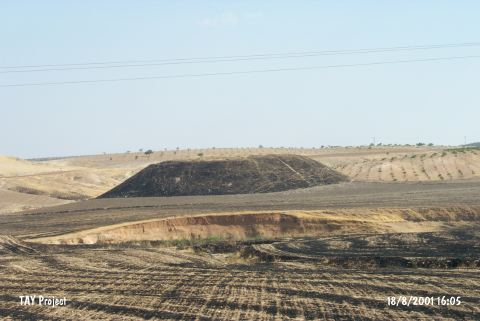
| Location: The site is east of the city of Gaziantep; between the villages of Kerzin and Kaleköy; southeast of the town of Nizip; 1.500 m east of the highway between Nizip and Cerabus and 8 km from Nizip itself. (Please see the Asagi Nizip Yöresi for more information on the sites in this region). |
| Geography and Environment: Perrot does not provide detailed geographical or topographical information on this site. |
| Destruction Details: The site is being destructed due to agricultural activities and illicit diggings [TAYEx 18.8.2001]. |