| ©The Archaeological Settlements of Turkey - TAY Project | ||||||
|
|
||||||
Kumtepe |
||||||
|
|
||||||
| Ages | Maps | Photos | ||||
| Chalcolithic EBA 14C |
 |
 |
||||
|
|
||||||
|
Type:
|
Mound | |||||
|
Altitude:
|
50 m | |||||
|
Diameter:
|
m- Direction: | |||||
|
|
||||||
|
Region:
|
Marmara | |||||
|
Province:
|
Çanakkale | |||||
|
District:
|
Merkez | |||||
|
Village:
|
Kumköy | |||||
|
|
||||||
|
Destruction :
|
Agriculture - Attention | |||||
|
|
||||||
|
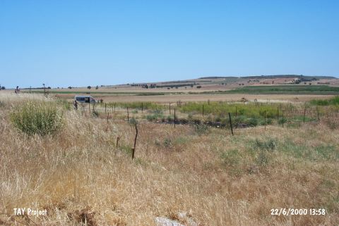
TAYEx:
|
Visited - 22/6/2000 | |||||
|
|
||||||
|
Registration State:
|
For detailed registration information please refer to Turkish pages. | |||||
 |
||||||
| Location: It lies on the western bank of Kara Menderes Stream; south of Kumkale; southwest of the Çanakkale Province. It is 2.5 km away from Dardanelles and 2 km away from the Aegean Sea. |
| Geography and Environment: Located on the western part of alluvial formed by the Kara Menderes Stream; it is a flat mound measuring 4-5 m in height and ca. 80x100 m in dimensions [Kosay-Sperling 1936:plan at 28]. Eastern slope of the mound has been truncated by Kara Menderes Stream while the upper part has been almost demolished due to recent leveling by bulldozer. Removal of stones by 15 trucks is an indication of the destruction caused on the architecture of the upper levels. |
| Destruction Details: The settlement was surrounded by barbed wire after the archaeological excavations but today this protection has been damaged and the architectural remains are ruined. The mound is leveled for agriculture [TAYEx 22.6.2000]. |