|
©The Archaeological Settlements of Turkey - TAY Project
|
|
|
|
|
|
Kumtepe |
|
|
For site maps and drawings please click on the picture...  |
For photographs please click on the photo... 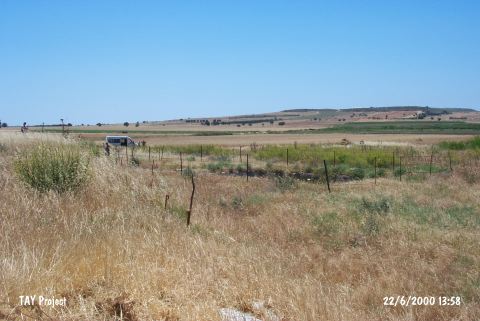 |
|
Type:
|
Mound |
|
Altitude:
|
50 m |
|
Region:
|
Marmara |
|
Province:
|
Çanakkale |
|
District:
|
Merkez |
|
Village:
|
Kumköy |
|
Investigation Method:
|
Excavation |
|
Period:
|
Late |
|
|
|
 |
|
| Location: It lies on the western bank of Kara Menderes Stream; south of Kumkale; southwest of the Çanakkale Province. It is 2.5 km away from Dardanelles and 2 km away from the Aegean Sea. |
| Geography and Environment: Located on the western part of alluvial formed by the Kara Menderes Stream; it is a flat mound measuring 4-5 m in height and ca. 80x100 m in dimensions [Kosay-Sperling 1936:plan at 28]. Eastern slope of the mound has been truncated by Kara Menderes Stream while the upper part has been almost demolished due to recent leveling by bulldozer. Removal of stones by 15 trucks is an indication of the destruction caused on the architecture of the upper levels. |
| History: |
| Research and Excavation: The mound was discovered by J.L. Caskey and J. Sperling during the 1934 campaign of excavations at Troy by Universities of Cincinnati [Arik 1953:79] and was excavated the same year by J. Sperling and H.Z. Kosay. The excavation was conducted in a total of 5 trenches; 4 at the north on the mound; 1 at the northwestern slope. The ditch-like trenches of 1.5x10 m do not constitute an efficient strategy for recovering the architectural texture of the settlement. Years later; the second campaign of Kumtepe excavations were initiated as a joint project of Troy Team and Çanakkale Museum; when it was heard that the mound was being destroyed. This second campaign was conducted by M. Korfmann between 1993 and 1997. |
| Stratigraphy: The results of the first campaign is two main strata in the 5 m high cultural deposit. Virgin soil is reached in two trenches and the levels are labeled from bottom to top as I; with three sublevels: a; b; c; and II. The relative chronology of the mound is fixed depending mostly on ceramic analysis as follows: Ia: Late Chalcolithic Age Ib: Late Chalcolithic Age / Early Bronze Age I Transitional Period: Pre-Troy I Ic: Early Bronze Age I: Troy I II: Early Bronze Age III b [Özdogan 1970:196]. The Phase I a is reported to be approximately 110 cm thick. The latest phase that could be recovered in the second campaign is I b; due to the loss of the higher levels by the severe destruction. I a phase could as well be observed. The stratigraphy set by Korfmann's team is in harmony with that of J. Sperling and H.Z. Kosay; for now. |
| Small Finds: Architecture: The architectural data of Phase Ia is faint since no detailed publication has been accomplished yet. There are two sub-phases of this phase which lies directly on virgin soil. The architectural remains of Phase Ib are sufficient at least for knowing the structure techniques. The adjacent rectangular structures have stone walls and the floors are paved with stone [Korfmann 1995:fig.6]. These remains belong to a building with 5 rooms; each covering an area of 5x7 m. The I b phase has three sub-phases. Pottery: Most of the pottery assemblage of the first campaign in 1934 are taken to Istanbul Archaeological Museum and the rest are kept at Ankara Museum of Anatolian Civilizations. The assemblage from the second campaign are preserved in Çanakkale Museum. The collection at Istanbul Archaeological Museum is studied in detail by M. Özdogan from University of Istanbul; Faculty of Letters; Prehistory Department [Özdogan 1970]. It is concluded in this analysis that the I a assemblage of the Chalcolithic Age includes ware groups such as fine red mottled ware; thin red burnished ware; and brown burnished ware [Özdogan 1970:174]. All wares are well-fired and the core is dark. Burnished decoration is observed on a few examples. The forms have flat bases; plain sides; and tapering rims. In I b phase yielding transitional material; there are sherds with light gray surface. They are highly burnished. Vessels with interiorly rounded rims are recovered. Ground Stone: Some burnished flat-axes are reported without any detailed information on them. The oval marble vessel found in a I a burial is coarsely made [Kosay-Sperling 1936:49]. The pedestal of this vessel bears no retouch; but the sides are thin and profound. Bone/Antler: Bone awls recovered from Neolithic until Bronze Ages do not show much typical development. Human Remains: Two burials are recovered in I a phase in the first campaign. One of these is a simple burial in which the body is in hocker position and the head is supported by a stone [Özgüç 1948b:6]. The body lies 15 cm above virgin soil. The second burial from the same phase is recovered in an ovoid pit dug probably into the main rock; in a depth of 460 m Trench A.1. The deceased lies in hocker position again in the 80 cm wide; 16 cm deep pit. There is a marble vessel piece beneath his knee [Kosay-Sperling 1936:49]. The analysis of these first inhabitants of Kumtepe concludes that they are Dolikosefal [Senyürek 1949; Arsebük 1969]. Numerous burials from I a Phase are reported by Korfmann in the second campaign [Korfmann 1996:291-292;fig.19; Korfmann 1997:218]. |
| Remains: |
| Interpretation and Dating: Kumtepe is an intriuging site; the finds of which are discussed by many scholars; since it was excavated in 1934; but was published in 1976. The reports of the second campaign are yet preliminary. Especially the pedestal of a fruit-stand among the sherds that were taken to the Ankara Museum of Anatolian Civilizations has led to a confusion about dating. With the joint project of the second campaign; he site has gained its crucial stand for the Late Chalcolithic-Early Bronze Ages of Western Anatolia. Korfmann cross-dates the site; depending on the 14C dates from the contemporary settlement of Besik-Sivritepe; to the beginning of the 5th Millennium BC [Korfmann 1995:247]. It is claimed to be interrelated with Beycesultan Late Chalcolithic 1-2; Alisar; Alacahöyük Late Chalcolithic Age; Can Hasan I; and Tigani. On the other hand 14C dates from Kumtepe I b are around 3100 BC. The total vanishing of the II and I c phases of the mound is the most striking example of the destruction of the sites in Northwestern Anatolia. |