| ©The Archaeological Settlements of Turkey - TAY Project | ||||||
|
|
||||||
Kulaksizlar |
||||||
|
|
||||||
| Ages | Maps | Photos | ||||
| Chalcolithic EBA |
 |
 |
||||
|
|
||||||
|
Type:
|
Workshop | |||||
|
Altitude:
|
60 m | |||||
|
Diameter:
|
m- Direction: | |||||
|
|
||||||
|
Region:
|
Aegean | |||||
|
Province:
|
Manisa | |||||
|
District:
|
Akhisar | |||||
|
Village:
|
Kulaksizlar | |||||
|
|
||||||
|
Destruction :
|
Agriculture | |||||
|
|
||||||
|
TAYEx:
|
Visited - 10/9/2000 | |||||
|
|
||||||
|
Registration State:
|
Registered For detailed registration information please refer to Turkish pages. | |||||
 |
||||||
| Location: The site lies northeast of the city of Manisa; west of the village of Kulaksiz which is 16 km southeast of Akhisar; in Balikburnu Mevkii between Kulaksiz Village and Akhisar-Gölmarmara road. Although it would be rather true to the fact to label the site as Balikburnu Mevkii; it is referred as Kulaksizlar; by the name of the village it is connected to; in the publications. |
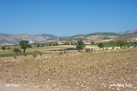
| Geography and Environment: Marble idols; marble vessel pieces; idol cores; flakes; and sherds are scattered in an area of approximately 12 000 square meter. Harmandali Mountain lying in east-west direction is located north of Kulaksiz Village and Akselendi Plain is located west of it. There are current marble quarries in Harmandali Mountain. It is assumed that those who worked the atelier labeled Kulaksizlar were using the same quarries and were possibly settled in Balikburnu Mevkii. Approximately 5 km Northeast of Kulaksızlar Locality is Harmandalı marble quarry. This region contains the marble quarries that supply the marble requirement of antique city of Thyateira until Late Antique Age [Akdeniz 2010:69]. |
| Destruction Details: The surface of the findspot is being used for cultivation [TAYEx 10.9.2000]. |