| ©The Archaeological Settlements of Turkey - TAY Project | ||||||
|
|
||||||
Anzavurtepe |
||||||
|
|
||||||
| Ages | Maps | Photos | ||||
| Neolithic |
 |
 |
||||
|
|
||||||
|
Type:
|
Artifact Scatter | |||||
|
Altitude:
|
15 m | |||||
|
Diameter:
|
m- Direction: | |||||
|
|
||||||
|
Region:
|
Marmara | |||||
|
Province:
|
Çanakkale | |||||
|
District:
|
Biga | |||||
|
Village:
|
Bakacak | |||||
|
|
||||||
|
Destruction :
|
Agriculture - Contemporary Settlements - Attention | |||||
|
|
||||||
|
TAYEx:
|
Visited - 1/7/2000 | |||||
|
|
||||||
|
Registration State:
|
Registered For detailed registration information please refer to Turkish pages. | |||||
 |
||||||
| Location: This site lies east-northeast of the city of Çanakkale; northwest of the town of Biga and near the town of Bakacak (it is not specified what part of the village the site lies in). |
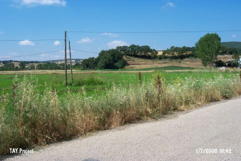
| Geography and Environment: Anzavurtepe; which lies by the southern border of the Biga Plain; is a natural hillock. The finds were found especially on the flanks of this hill and on the fields around it [Özdogan 1990:450; fig.2]. Part of the hill and the surrounding region is wooded as evident in the site photo published by Özdogan. Bakacak stream flows on the western side of the settlement. No information has been provided on flint outcrops in the vicinity. |
| Destruction Details: A gas station was built on the mound. The other parts are damaged by terracing. There are traces of illicit diggings and a road that goes to the top of the hill [TAYEx 1.7.2000]. |