| ©The Archaeological Settlements of Turkey - TAY Project | ||||||
|
|
||||||
Kefken - Cebeci Yöresi |
||||||
|
|
||||||
| Ages | Maps | Photos | ||||
| Palaeolithic/Epipalaeolithic |
 |
 |
||||
|
|
||||||
|
Type:
|
Habitation Site / Workshop | |||||
|
Altitude:
|
0 m | |||||
|
Diameter:
|
m- Direction: | |||||
|
|
||||||
|
Region:
|
Marmara | |||||
|
Province:
|
Kocaeli | |||||
|
District:
|
Kandira | |||||
|
Village:
|
Cebeci | |||||
|
|
||||||
|
Destruction :
|
Mines/Quarries - Contemporary Settlements - Attention | |||||
|
|
||||||
|
TAYEx:
|
Visited - 24/11/2000 | |||||
|
|
||||||
|
Registration State:
|
For detailed registration information please refer to Turkish pages. | |||||
 |
||||||
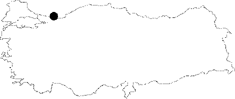
| Location: This open-air site is north of the city of Izmit; on the Black Sea coast; near the town of Kandira. It lies in the village of Kefken (old Mansuriye) and in the area east of it; between this village and the village of Cebeci. |
| Geography and Environment: In antiquity this town was called "Kafganos"; literally meaning "stony area" [Bijiskyan 1969:19]. Beyond the beach approximately 1.5 km from Kefken is a bay where small boats can harbor. The rivers of the Kocaeli Peninsula on which the villages of Kefken and Cebeci lie are oriented north or northwest. The topography of the peninsula is hilly but includes plateau areas and valleys. There are also a few forested areas nearby. |
| Destruction Details: The findspot has been vanished under the sand quarry and contemporary settlements [TAYEx 24.11.2000]. |