| ©The Archaeological Settlements of Turkey - TAY Project | ||||||
|
|
||||||
Keçili |
||||||
|
|
||||||
| Ages | Maps | Photos | ||||
| Neolithic |
 |
 |
||||
|
|
||||||
|
Type:
|
Mound | |||||
|
Altitude:
|
810 m | |||||
|
Diameter:
|
m- Direction: | |||||
|
|
||||||
|
Region:
|
Mediterranean | |||||
|
Province:
|
Burdur | |||||
|
District:
|
Bucak | |||||
|
Village:
|
Keçili | |||||
|
|
||||||
|
Destruction :
|
Agriculture | |||||
|
|
||||||
|
TAYEx:
|
Visited - 26/6/2001 | |||||
|
|
||||||
|
Registration State:
|
For detailed registration information please refer to Turkish pages. | |||||
 |
||||||
| Location: This site lies south of the city of Burdur; southeast of the town of Bucak; in the northern part of the narrow valley between Lake Anbahan and Lake Kestel. It lies in Helvacitepesi Mevkii; 1.5 km south of the village of Keçili. |
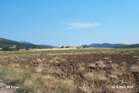
| Geography and Environment: The mound lies between the two lakes; in the northern part of the Kilde Valley; on Mount Helvacitepesi; a northwestern extension of Mount Karagan/Kiragan. The site was named Keçili by Özsait; who discovered it; because Keçili is the closest village to the site. The extent of the scatter of ceramics and other finds has not been given because the site lies on a natural ridge. The mound is currently cultivated. |
| Destruction Details: The mound has been damaged due to agricultural activities. It is completely planted [TAYEx 26.6.2001]. |