| ©The Archaeological Settlements of Turkey - TAY Project | ||||||
|
|
||||||
Karain Magarasi |
||||||
|
|
||||||
| Ages | Maps | Photos | ||||
| Palaeolithic/Epipalaeolithic Neolithic Chalcolithic EBA 14C |
 |
 |
||||
|
|
||||||
|
Type:
|
Cave | |||||
|
Altitude:
|
360 m | |||||
|
Diameter:
|
m- Direction: | |||||
|
|
||||||
|
Region:
|
Mediterranean | |||||
|
Province:
|
Antalya | |||||
|
District:
|
Merkez | |||||
|
Village:
|
Yagca | |||||
|
|
||||||
|
|
||||||
|
|
||||||
|
TAYEx:
|
Visited - 20/6/2001 | |||||
|
|
||||||
|
Registration State:
|
Registered For detailed registration information please refer to Turkish pages. | |||||
 |
||||||
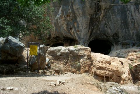
| Location: This cave site is approximately 27 km northwest of the city of Antalya; immediately northeast of the village of Yagca. It is connected to Antalya with an asphalt road and easy to reach. Code V 19 / 1. |
| Geography and Environment: The cave is a natural hollow carved into the steep karstic limestone flanks of Mount Çadir Tepesi; an extension of Mount Katran (Çam). The cave consists of three different spacious galleries. The outermost first gallery that receives the most light is divided into five different chambers and labeled A; B;C and D. According to the finds; it was understood that all of these chambers were not inhabited during the Chalcolithic. |
| Destruction Details: |