|
©The Archaeological Settlements of Turkey - TAY Project
|
|
|
|
|
|
Karain Magarasi |
|
|
For site maps and drawings please click on the picture... 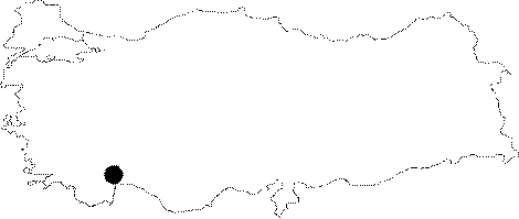 |
For photographs please click on the photo... 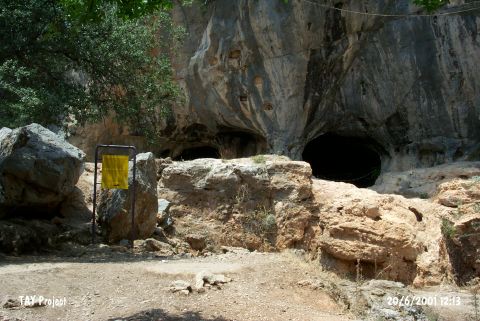 |
|
Type:
|
Cave |
|
Altitude:
|
360 m |
|
Region:
|
Mediterranean |
|
Province:
|
Antalya |
|
District:
|
Merkez |
|
Village:
|
Yagca |
|
Investigation Method:
|
Excavation |
|
Period:
|
Ceramic |
|
|
|
 |
|
| Location: This cave site is approximately 27 km northwest of the city of Antalya; immediately northeast of the village of Yagca. It is connected to Antalya with an asphalt road and easy to reach. Code V 19 / 1. |
| Geography and Environment: The cave is a natural hollow carved into the steep karstic limestone flanks of Mount Çadir Tepesi; an extension of Mount Katran (Çam). The cave consists of three different spacious galleries. The outermost first gallery that receives the most light is divided into five different chambers and labeled A; B;C and D. According to the finds; it was understood that all of these chambers were not inhabited during the Chalcolithic. |
| History: |
| Research and Excavation: The Karain cave-site was discovered by Kiliç Kökten and his student; Fikret Ozansoy; in 1946 during a side survey they conducted while doing research at the Gurma (Kurma) Cave in the Antalya Region. When the cave was discovered; it was difficult to enter because the entrance was blocked by a thick travertine wall. After blasting the travertine with dynamite the cave was widely investigated. As a result of the chipped stone finds encountered on the present floor of the cave Kökten has decided to excavate the cave. The excavation was started in 1946 in Chamber A which had the most light. The excavations conducted under Kökten's direction continued until 1972. Chalcolithic Age sherds were recovered at the uppermost level of Galleries B and E during the 1946-72 excavations. Excavations were halted for over a decade following Kökten's death in 1974. The trenches were reopened in 1985 by Isin Yalçinkaya; a member of Kökten's excavation team; who wanted to further understand the chipped stone sequences; the stratigraphy; the faunal and floral assemblages of the site. It was interpreted that the cave was settled for a long time at this age. Chalcolithic sherds were recovered at an area of 4 square meters; 13 m away from the entrance and from Kökten's trenches; during the excavation conducted by I. Yalçinkaya in 1985. The Chalcolithic Age stratigraphy of the cave was obtained [Yalçinkaya 1987:23]. Excavation project led by Yalçinkaya became international as H.J. Müller-Beck from the University of Tubingen and M. Otte from the University of Liege joined the team. The team excavated the site until 2014 and in 2015 H. Taskiran took over the project. It is listed in the registered archaeological preservation zones inventory prepared by Ministry of Culture and Tourism. |
| Stratigraphy: Some material assigned to the Neolithic was found in the uppermost levels excavated during the Kökten excavations. No detailed information was published on these finds. Although Kökten reports that this Neolithic material was discovered in Chamber B; excavations under Yalçinkaya's direction in this chamber yielded Chalcolithic material instead. It is not; therefore; certain whether there was a Neolithic habitation of this cave. The Stratigraphy of Gallery B: The results of the recent studies indicate that the stratigraphy of Gallery B consists of deposits belonging to Holocene and Pleistocene. The Holocene levels were labeled as "H" and separated into 5 different geological units. The Pleistocene levels, on the other hand, were assigned as "P" and divided into 10 geological units. This separation is based on geological units. Therefore, they do not represent cultural differences. The Holocene levels as it follows: H.I: The remains belonging to Byzantine and Roman periods as well as modern and recent past. Probably it represents a midden / refuse area belonging to the period in which the terrace of the cave was occupied. H.II: The level containing mixed EBA and Chalcolithic finds. H.III: Mostly Chalcolithic finds. H.IV: Chalcolithic and Late Neolithic. H.V: Late Neolithic. The Pleistocene levels: P.I.1 and P.I.2: Epipalaeolithic. P.I.3: Upper Palaeolithic-Epipalaeolithic transition period. P.II: Upper Palaeolithic. P.III: Middle Palaeolithic-Upper Palaeolithic transition period. P.IV: Karain Type Mousterien P.V: Karain Type Mousterien and Zagros Type Mousterien P.VI: Dominated by flake technology. The usage of the Levallois technique beginning from P.IV continues in P.VI as well. P.VII: Karain Type Mousterien P.VIII: 6 retouched flakes, 4 side scrapers, 1 denticulated tool and 4 cores were found. P.IX: 9 side scrapers, 1 Levallois point, 5 retouched flakes, 1 retouched blade, 1 denticulated tool and 1 notched side scraper were found. P.X: 5 side scrapers, 2 Mousterien points, 1 notched and 1 retouched flake, 1 denticulated tool were found. Side scrapers are common. P.XI: 1 side scraper, 2 typical Mousterien points were found [Yaman 2012]. |
| Small Finds: In Gallery B, the 2012 excavation campaign was carried out in 22 plan squares in total. 65 archaeological levels were removed within 2 separate geological levels. The most interesting discovery was the stake holes. 16 stake holes that were exposed in various plan squares were dug into the Holocene levels [Yalçinkaya et al. 2014:237-238]. During the 2013 studies carried out in Gallery B, the continuation of postholes that were exposed in previous year. 19 postholes were found and the total number of postholes reached to 35. It is believed that these postholes were used to construct a hut-like structure inside the cave [Yalçinkaya et al. 2015:447-448]. Pottery: It is reported that the ceramic vessels at Karain Cave have flaring mouths and lugs. Mellaart believes that this ware resembles Kizilkaya/Bademagaci ware [Mellaart 1961b:169]. From the information Kökten supplies in one of his publications [Kökten 1955:fig.IV]; Todd concludes that the oldest ceramics at the site include Dark Burnished Ware and flaring vessel forms [Todd 1980:142]. A potsherd with relief of a bull head was found in the plan squares J12 and K12 in 2013. This potsherd is buff colored and mica tempered [Yalçinkaya et al. 2015:448]. Chipped Stone: The microlithics consist of retouched flake and blades, truncated blades, end scrapers in various types, stone borers and drills, denticulated and notched tools and sickle blades and stone burins in small quantity. Among the microliths, there are backed bladelets, retouched bladelets, microgravette points and truncated bladelets. The majority of the cores consist of unipolar and bipolar prismatic cores, amorphous cores and reduced cores in various types [Yalçinkaya et al. 2014:241]. During the 2013 excavations, retouched and unretouched flakes and blades, macrolith and microlith tools, knapping waste and chips were found in the geological level H.V dated to Late Neolithic [Yalçinkaya et al. 2015:449]. Fauna: A great number of animal bones were found. The ones belonging to the macro fauna were regarded as leftovers. These bones, which could belong to the bovidae, bear butchering marks. Sheep and goat species are common among the faunal assemblage. The fact that almost all the bones of the animal skeletons were found indicates that these animals were chopped in the settlement [Yalçinkaya et al. 2014:241]. Human Remains: Jaw fragment and finger bones belonging to human were found in 2013 in the plan square I 14 [Yalçinkaya et al. 2015:448]. Other: A stone pendant in the form of a bull head was found in the plan square H 10 in Level H.V that is dated to the Late Neolithic. The plan square H 13 yielded a bone ring. The bone industry composes of awls, points and perforated objects. Beads and ornaments made out of stone, dentalium and shell were found as well [Yalçinkaya et al. 2014:240-241]. Worked bone objects, bone spoon and bone needles were found in 2013 [Yalçinkaya et al. 2015:450]. |
| Remains: |
| Interpretation and Dating: The possibility that there is was Neolithic habitation in the cave is totally dependent on the information given by Kökten. The validity of this claim has been questioned by Yalçinkaya's interpretation of these layers. Her excavations show that the top three layers date to the Chalcolithic Period. It is difficult to say whether there was Neolithic habitation at the site. Perhaps there may have been a very short Neolithic habitation in one corner of the cave. Mellaart places this site among his list of Neolithic sites in the area based on some microliths found in the cave. There has; however; never been a publication describing Neolithic microliths from this cave [Mellaart 1975:fig.11 and maps in 81]. Although the Neolithic assignment of this site is skeptical; Mellaart's conclusions were considered ASPRO where the site has been placed in to Phase 6/1 [Hours et al. 1994:197]. A Neolithic habitation at this site remains questionable. Radiolaritine, flint and obsidian were used as raw material in the chipped stone industry of Late Neolithic Period (H.V) of Karain Cave. Radiolaritine is local raw material obtained from Kizilin Creek near the cave. It was commonly used. It is suggested that flint and obsidian were imported since there is no source around the cave. The macroscopic analyses make one think that obsidian was obtained from Central Anatolia. In addition, the source analysis of obsidians found in Öküzini that is located at a distance of 1 km from Karain shows that Öküzini obsidian was obtained from Central Anatolia [Kartal 2015:56-57]. |