| ©The Archaeological Settlements of Turkey - TAY Project | ||||||
|
|
||||||
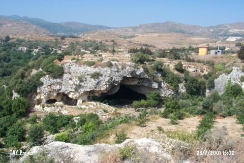
Incili / Büyük Magara |
||||||
|
|
||||||
| Ages | Maps | Photos | ||||
| Palaeolithic/Epipalaeolithic |
 |
 |
||||
|
|
||||||
|
Type:
|
Cave | |||||
|
Altitude:
|
30 m | |||||
|
Diameter:
|
m- Direction: | |||||
|
|
||||||
|
Region:
|
Mediterranean | |||||
|
Province:
|
Hatay | |||||
|
District:
|
Samandag | |||||
|
Village:
|
Magaracik | |||||
|
|
||||||
|
|
||||||
|
|
||||||
|
TAYEx:
|
Visited - 23/7/2001 | |||||
|
|
||||||
|
Registration State:
|
For detailed registration information please refer to Turkish pages. | |||||
 |
||||||
| Location: This cave is southwest of the city of Antakya; south of the village of Çevlik which is northwest of the town of Samandag. The cave referred to as Büyük Magara (literally "large cave") is only 300 meters from the Kanal Magara Cave. This cave does not have a local name but was nicknamed Incili Magara (literally "cave with pearl") after excavations yielded a pearl. The cave is only 30 meters from the Roman water canal and 100-150 meters from the Mediterranean Sea. |
| Geography and Environment: The cave lies in limestone cliffs formed in the Tertiary Period which today are sheltered directly from the sea because they are in a small bay. It is assumed that the cave was formed by wave-action in the Quaternary Period. The interior of the cave is wide and clean. Its dimensions have not been published although it is noted that the mouth of the cave is 6 m above sea level. In the cave is a wall constructed during rock quarrying activities and 6 m of depositional fill. Many large flintstone nodules can be found among the Tortonian layers west of Çevlik Bay. |
| Destruction Details: |