|
©The Archaeological Settlements of Turkey - TAY Project
|
|
|
|
|
|
Incili / Büyük Magara |
|
|
For site maps and drawings please click on the picture...  |
For photographs please click on the photo... 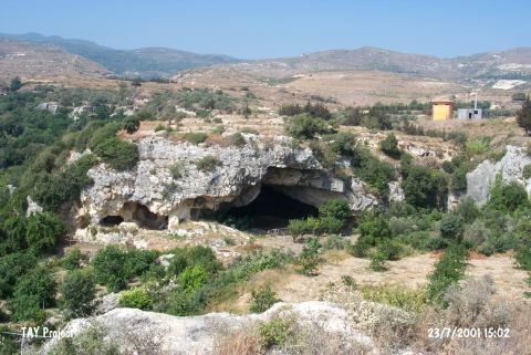 |
|
Type:
|
Cave |
|
Altitude:
|
30 m |
|
Region:
|
Mediterranean |
|
Province:
|
Hatay |
|
District:
|
Samandag |
|
Village:
|
Magaracik |
|
Investigation Method:
|
Excavation |
|
Period:
|
ÜP |
|
|
|
 |
|
| Location: This cave is southwest of the city of Antakya; south of the village of Çevlik which is northwest of the town of Samandag. The cave referred to as Büyük Magara (literally "large cave") is only 300 meters from the Kanal Magara Cave. This cave does not have a local name but was nicknamed Incili Magara (literally "cave with pearl") after excavations yielded a pearl. The cave is only 30 meters from the Roman water canal and 100-150 meters from the Mediterranean Sea. |
| Geography and Environment: The cave lies in limestone cliffs formed in the Tertiary Period which today are sheltered directly from the sea because they are in a small bay. It is assumed that the cave was formed by wave-action in the Quaternary Period. The interior of the cave is wide and clean. Its dimensions have not been published although it is noted that the mouth of the cave is 6 m above sea level. In the cave is a wall constructed during rock quarrying activities and 6 m of depositional fill. Many large flintstone nodules can be found among the Tortonian layers west of Çevlik Bay. |
| History: |
| Research and Excavation: The cave site was excavated under the direction of Enver Bostanci in 1970; 1971 and 1973. A 400x525 cm trench was dug close to the mouth of the cave. Bedrock was reached at 499 cm below the surface. The stratigraphic numbering of the layers is confusing because although letters are used to identify the layers in one of his publications; another publication uses numbers. The first 9 layers are post-Roman. The finds from these layers; totaling 274 cm in thickness; have not been reported. Layer 10; which is 53 cm thick; is contemporaneous with the settlement of the ancient city of Selevkia Pierra. Large quantities of pottery and broken glass were recovered from this light-colored calcareous layer. The underlying layer was a greyish-white 40 cm thick stratum which yielded many fragmentary pieces of human bone. Layer 12 was entirely composed of sand formed in a period when sea level was lower. Layer 13; the final layer above bedrock; yielded no artifacts or human remains. |
| Stratigraphy: |
| Small Finds: The excavation director dates Layer 12 to the Upper Palaeolithic. Although no chipped stone tools were found; the human skeleton and the pierced shells that were probably used as decorative ornaments are at least 50;000 years old. Bostanci suggests that the Upper Palaeolithic cave dwellers of Kanal Magarasi may have occasionally used this area as a campsite. Beneath the sand is a layer consisting of shells and stones originating from Syria; which must have found its way to the shores of Antakya by way of the sea. The pearl after which the site has been named was also found in this layer. |
| Remains: |
| Interpretation and Dating: |