| ©The Archaeological Settlements of Turkey - TAY Project | ||||||
|
|
||||||
Aciyer |
||||||
|
|
||||||
| Ages | Maps | Photos | ||||
| Neolithic |
 |
 |
||||
|
|
||||||
|
Type:
|
Slope Settlement | |||||
|
Altitude:
|
1180 m | |||||
|
Diameter:
|
99 m- Direction: S-N | |||||
|
|
||||||
|
Region:
|
Central Anatolia | |||||
|
Province:
|
Aksaray | |||||
|
District:
|
Merkez | |||||
|
Village:
|
Agzikarahan | |||||
|
|
||||||
|
Destruction :
|
Contemporary Settlements | |||||
|
|
||||||
|
TAYEx:
|
Visited - 4/8/2002 | |||||
|
|
||||||
|
Registration State:
|
Registered For detailed registration information please refer to Turkish pages. | |||||
 |
||||||
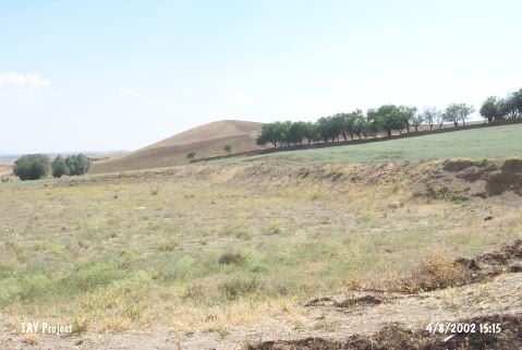
| Location: This site lies at the southwestern entrance of Agzikarahan Village by the Aksaray-Nevsehir highway; northeast of Aksaray Province. |
| Geography and Environment: There is a small stream between the site and the village of Agzikarahan. The site has been destroyed by the terracing activities. |
| Destruction Details: The site has been leveled due to make a football field [TAYEx 4.8.2002]. |