|
©The Archaeological Settlements of Turkey - TAY Project
|
|
|
|
|
|
Aciyer |
|
|
For site maps and drawings please click on the picture...  |
For photographs please click on the photo... 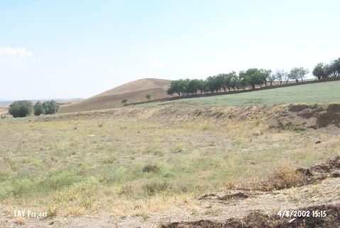 |
|
Type:
|
Slope Settlement |
|
Altitude:
|
1180 m |
|
Region:
|
Central Anatolia |
|
Province:
|
Aksaray |
|
District:
|
Merkez |
|
Village:
|
Agzikarahan |
|
Investigation Method:
|
Survey |
|
Period:
|
Aceramic |
|
|
|
 |
|
| Location: This site lies at the southwestern entrance of Agzikarahan Village by the Aksaray-Nevsehir highway; northeast of Aksaray Province. |
| Geography and Environment: There is a small stream between the site and the village of Agzikarahan. The site has been destroyed by the terracing activities. |
| History: |
| Research and Excavation: The site was discovered during the Aksaray Project in 1944; directed by U. Esin of the University of Istanbul (Faculty of Letters; Department of Prehistory) and by S. Gülçur during the surface survey she conducted in the Aksaray; Nigde and Nevsehir provinces. It takes place in the registered archaeological sites list prepared by Ministry of Culture and Tourism. |
| Stratigraphy: |
| Small Finds: More than 900 chipped stone tools were recovered during the surface surveys. The most common finds were scrapers on flakes. In order of abundance; the site yielded blades with edge wear and edge retouchings; scrapers on blades; points; burins and geometric tools. |
| Remains: |
| Interpretation and Dating: The study of the obsidian surface finds collected during the Aciyer survey revealed that the chipped stone technology; the tools themselves and even the tool-find densities are in many ways similar to those at the Aceramic Neolithic site of Asikli Höyük [Balkan-Atli; in press]. |