| ©The Archaeological Settlements of Turkey - TAY Project | ||||||
|
|
||||||
Ilicapinar |
||||||
|
|
||||||
| Ages | Maps | Photos | ||||
| Neolithic |
 |
 |
||||
|
|
||||||
|
Type:
|
Mound | |||||
|
Altitude:
|
955 m | |||||
|
Diameter:
|
m- Direction: | |||||
|
|
||||||
|
Region:
|
Central Anatolia | |||||
|
Province:
|
Konya | |||||
|
District:
|
Cihanbeyli | |||||
|
Village:
|
Ilica | |||||
|
|
||||||
|
|
||||||
|
|
||||||
|
TAYEx:
|
Visited - 31/7/2002 | |||||
|
|
||||||
|
Registration State:
|
Registered For detailed registration information please refer to Turkish pages. | |||||
 |
||||||
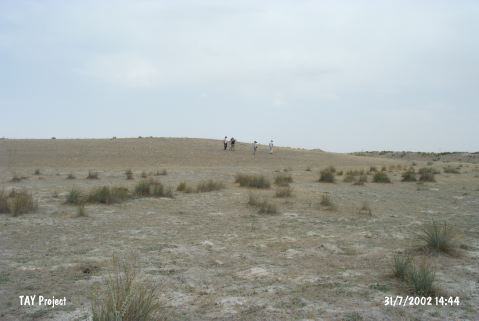
| Location: This site is located east of the city of Konya; approximately 11 km south of the town of Cihanbeyli; east of the village of Ilicapinar. The mound lies on a flat area next to a natural hill; immediately south of the unpaved road that goes from Ilica to the villages of Yapali and Cüdkanli. It is possible to get to the site by taking the Ilicapinar turn-off from the Konya-Cihanbeyli highway and then by taking another turn-off onto the unpaved road to Yapali. |
| Geography and Environment: The low-lying mound-site lies at the northernmost corner of Acituz Lake (also known as Bulok or Bolluk Lake). East of the mound is a freshwater spring. The dimensions of the mound have not been provided. The obsidian tools and weapons found at the site were concentrated on the southern and eastern skirts of the mound; the other parts of the mound yielded more total obsidian finds but less tools. The relationship between this equation and the settlement distribution is not known. The southeastern part of the mound is a swamp. The soil around the site is not very fertile. One advantage of the site's location is that it is close to the Salt Lake. |
| Destruction Details: |