| ©The Archaeological Settlements of Turkey - TAY Project | ||||||
|
|
||||||
Hasköy |
||||||
|
|
||||||
| Ages | Maps | Photos | ||||
| EBA IA |
 |
 |
||||
|
|
||||||
|
Type:
|
Mound | |||||
|
Altitude:
|
70 m | |||||
|
Diameter:
|
m- Direction: | |||||
|
|
||||||
|
Region:
|
Marmara | |||||
|
Province:
|
Edirne | |||||
|
District:
|
Enez | |||||
|
Village:
|
Hasköy | |||||
|
|
||||||
|
Destruction :
|
Highways, roads, bridges etc. | |||||
|
|
||||||
|
TAYEx:
|
Visited - 16/6/2000 | |||||
|
|
||||||
|
Registration State:
|
For detailed registration information please refer to Turkish pages. | |||||
 |
||||||
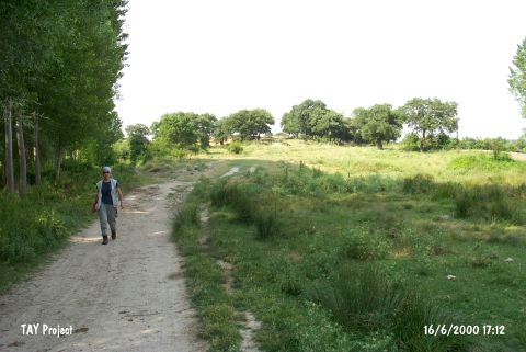
| Location: It lies east of the Hasköy Health House on the northern side of the Enez-Kesan motorway; southeast of the Enez District; south-southwest of the Edirne Province. It is easily accessible since it is only 100 m far from the motorway; but it can not be easily noticed from a far distance. |
| Geography and Environment: It is an oval flat hill. It measures 65x30 m in dimensions located between the higher hills on the south and east. Since it is combined with the northern ridge on the same level; the rocky block looks like an extension of the ridge. However; it is 9 m high from the field on the west. S. Basaran reports that the mound looks like an island in the middle of the streams flowing on the east and the west. As the hill is protected against the cold winter winds; the site was occupied not only during the prehistoric ages; but also in later periods. The spring on the southern slope still supplies water to the modern village. |
| Destruction Details: A secondary road of the village passes over the settlement. This road has uncovered some late period walls and damaged the upper layers. The remains are especially evident on the northern section [TAYEx 16.6.2000]. |