| ©The Archaeological Settlements of Turkey - TAY Project | ||||||
|
|
||||||
Hasanusagi al Dai'ah |
||||||
|
|
||||||
| Ages | Maps | Photos | ||||
| Neolithic |
 |
 |
||||
|
|
||||||
|
Type:
|
Mound | |||||
|
Altitude:
|
190 m | |||||
|
Diameter:
|
m- Direction: | |||||
|
|
||||||
|
Region:
|
Mediterranean | |||||
|
Province:
|
Hatay | |||||
|
District:
|
Reyhanli | |||||
|
Village:
|
Hasanusagi | |||||
|
|
||||||
|
Destruction :
|
Agriculture - Contemporary Settlements | |||||
|
|
||||||
|
TAYEx:
|
Visited - 18/7/2001 | |||||
|
|
||||||
|
Registration State:
|
For detailed registration information please refer to Turkish pages. | |||||
 |
||||||
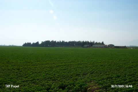
| Location: This site lies northeast of the city of Antakya; 14.5 km west-northwest of the town of Reyhanli; and approximately 1 km from Lake Antioch before it was partially dried. It lies beneath the village of Hasanusagi. |
| Geography and Environment: The site of Hasanusagi; also known as Üçtepe (which literally means three hills); is comprised of three relatively small and low mounds. Now; a modern village is built on one of the mounds. The fields around the site are fertile. West of the site is a swamp/marsh. |
| Destruction Details: There is a farm on top hill and the rest of the mound is cultivated. There are leveled areas east; southeast and north of the mound. It has been severely damaged due to plowing [TAYEx 18.7.2001]. |