| ©The Archaeological Settlements of Turkey - TAY Project | ||||||
|
|
||||||
Harmanören / Göndürle |
||||||
|
|
||||||
| Ages | Maps | Photos | ||||
| EBA |
 |
 |
||||
|
|
||||||
|
Type:
|
Mound and Cemetery | |||||
|
Altitude:
|
890 m | |||||
|
Diameter:
|
m- Direction: | |||||
|
|
||||||
|
Region:
|
Mediterranean | |||||
|
Province:
|
Isparta | |||||
|
District:
|
Atabey | |||||
|
Village:
|
Harmanören | |||||
|
|
||||||
|
Destruction :
|
Agriculture - Contemporary Settlements | |||||
|
|
||||||
|
TAYEx:
|
Visited - 2/7/2001 | |||||
|
|
||||||
|
Registration State:
|
Registered For detailed registration information please refer to Turkish pages. | |||||
 |
||||||
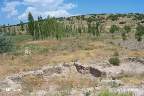
| Location: It lies southeast of Harmanören Village; former name Göndürle; about 27 km northeast of Isparta Province. The cemetery claimed to be the cemetery of Göndürle I Höyügü by the researchers is located in the garden of almond trees at Tepecikalti or Tavsanlik Mevkii on the southern foothill of Tavsantepe with an altitude of 1014 m rising 1 km east of the village. The mound cited as Göndürle in the archaeological literature is situated 250-300 m southeast of this cemetery [Özsait 1994:29]. Therefore; the first mound was called Göndürle in order to prevent any confusion between these two mounds. The cemetery is called as the EBA cemetery of Göndürle. |
| Geography and Environment: The mound is located at the beginning of a plain on the south of the hills where the village of Göndürle is situated. The cemetery; 250-350 m northwest of the mound extends in the northwest- southeast direction on the southern foothill of Tavsantepe in parallel to the mountains. It is reported to cover an area of 1880 square meters and have a diameter of 300 m whereas the mound measures 100x150 m in dimensions. |
| Destruction Details: The mound has been damaged due to agricultural activities. There is a high voltage power tower on top hill and houses on southwest and south-southeast skirts [TAYEx 2.7.2001]. |