| ©The Archaeological Settlements of Turkey - TAY Project | ||||||
|
|
||||||
Hacibeyli |
||||||
|
|
||||||
| Ages | Maps | Photos | ||||
| Neolithic IA |
 |
 |
||||
|
|
||||||
|
Type:
|
Mound | |||||
|
Altitude:
|
1310 m | |||||
|
Diameter:
|
120 m- Direction: SW-NE | |||||
|
|
||||||
|
Region:
|
Central Anatolia | |||||
|
Province:
|
Nigde | |||||
|
District:
|
Merkez | |||||
|
Village:
|
Hacibeyli | |||||
|
|
||||||
|
Destruction :
|
Agriculture | |||||
|
|
||||||
|
TAYEx:
|
Visited - 8/8/2002 | |||||
|
|
||||||
|
Registration State:
|
For detailed registration information please refer to Turkish pages. | |||||
 |
||||||
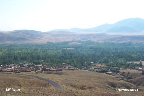
| Location: The mound-site of Hacibeyli Höyük is located northwest of the city of Nigde. It is accessible via the road to Hacibeyli Village from Dikilitas Village; which is approximately 23 km from the intersection of Dikilitas at Hüyük on the Nigde-Kayseri Highway. The mound is situated 1.3 km east from Hacibeyli Village and it constitutes the border between Dündarli and Hacibeyli. The mound is accessed via the dirt road through the gardens. The mound is called "Hacibeyli Höyük" after the closest village. Or plain "Höyük" as the locals call it. Two hillocks can be seen among the groves if you look east of the ridge west of the village of Hacibeyli. The mound is the southern of these two hillocks. |
| Geography and Environment: The mound; which is approximately 1;070 m above sea-level lies at the base of a valley which lies perpendicular to Yay Lake (also known as Sultansazligi or Kurbaga Lake). It lies 130 m above the level of the lake. The mound is reported to be 10 m high and to have approximately a 100 m diameter (although it is slightly oval in shape). While the upper part and southern flank of the mound is used as a wheat field; the northern part; like the valley itself; is an apple grove. East of the mound is a stream that springs from Mount Aladag and flows north to south before emptying into Yay Lake. The stream flows regardless of season and is 3-4 m wide and relatively shallow. It is not known whether there are nearby springs or if these streams functioned as water sources for the inhabitants of the mound. |
| Destruction Details: There are apple gardens at the eastern and northern sections of the mound and watering channel passes on northeast skirt [TAYEx 8.8.2002]. |