|
©The Archaeological Settlements of Turkey - TAY Project
|
|
|
|
|
|
Hacibeyli |
|
|
For site maps and drawings please click on the picture...  |
For photographs please click on the photo... 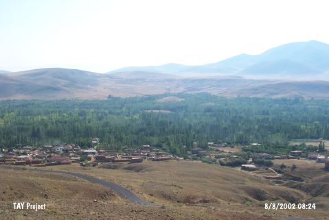 |
|
Type:
|
Mound |
|
Altitude:
|
1310 m |
|
Region:
|
Central Anatolia |
|
Province:
|
Nigde |
|
District:
|
Merkez |
|
Village:
|
Hacibeyli |
|
Investigation Method:
|
Survey |
|
Period:
|
Aceramic |
|
|
|
 |
|
| Location: The mound-site of Hacibeyli Höyük is located northwest of the city of Nigde. It is accessible via the road to Hacibeyli Village from Dikilitas Village; which is approximately 23 km from the intersection of Dikilitas at Hüyük on the Nigde-Kayseri Highway. The mound is situated 1.3 km east from Hacibeyli Village and it constitutes the border between Dündarli and Hacibeyli. The mound is accessed via the dirt road through the gardens. The mound is called "Hacibeyli Höyük" after the closest village. Or plain "Höyük" as the locals call it. Two hillocks can be seen among the groves if you look east of the ridge west of the village of Hacibeyli. The mound is the southern of these two hillocks. |
| Geography and Environment: The mound; which is approximately 1;070 m above sea-level lies at the base of a valley which lies perpendicular to Yay Lake (also known as Sultansazligi or Kurbaga Lake). It lies 130 m above the level of the lake. The mound is reported to be 10 m high and to have approximately a 100 m diameter (although it is slightly oval in shape). While the upper part and southern flank of the mound is used as a wheat field; the northern part; like the valley itself; is an apple grove. East of the mound is a stream that springs from Mount Aladag and flows north to south before emptying into Yay Lake. The stream flows regardless of season and is 3-4 m wide and relatively shallow. It is not known whether there are nearby springs or if these streams functioned as water sources for the inhabitants of the mound. |
| History: |
| Research and Excavation: The site was discovered in 1990 during the survey in the Kaman; Kirsehir; Aksaray; Kayseri Region; conducted by the Japanese excavation crew of Kaman Kalehöyük [Omura 1992:542]. A more detailed survey was conducted here in 1993 because Neolithic finds were collected in the initial survey. The northern part of the site; where there is a 30 m long and 4-5 m high section exposed; was destroyed probably when an apple grove was planted. |
| Stratigraphy: In addition to Aceramic Neolithic finds; the surface of the mound yielded Iron Age and Early Bronze Age ceramics. A 2-3 m thick Iron Age and Early Bronze Age deposit appears to overlie a 1.5-2 m thick Aceramic Neolithic layer with a large quantity of obsidian chipped stone tools as seen in the mound profile. It is assumed that the mound is therefore composed of two main layers. Cross sections of mudbrick architectural structures were found in the lower; Neolithic Layer. The walls appear to have been preserved to the height of 1m; and the floors are pebble lined. Burnt floors can also be found. Mudbrick walls are made with 20-30 cm long and 6-7 cm wide light brown bricks. The fact that different types of clay were used for the mortar and the mudbrick can be seen in the section. |
| Small Finds: Architecture: In the lower level; where no ceramics were found; the mudbrick walls are preserved to the height of 1 m. The mudbricks are light brown in color and 20-30 m long and 6-7 cm thick. It is clear that the mortar is made from a separate type of clay than the mudbricks. There is no mention of plaster on the walls. The large quantities of charcoal and ash is informative about the type of roofs that the houses may have had. Chipped Stone: A careful surface collection of chipped stone artifacts; especially in the damaged part of the mound; was conducted. The finds were then typologically and technologically analyzed by Fujii [Fujii 1994:131-152]. This researcher informs that the Aceramic Neolithic inhabitants of the site of Hacibeyli preferred a semi-transparent; black obsidian as the raw material for their chipped stone tools. Another gray and less transparent obsidian is occasionally used. Chert is rare. Flake cores have been found in addition to blade cores although the latter is the dominant core type and constitutes 68% of all the cores. 59% of the 122 finds collected are tools which include retouched and used blades; knives; flakes; notched blades; burins; scrapers; perforators; and splinter pieces. Grinding Stone: Presence of specimens such as mortar pestles on the surface was reported. |
| Remains: |
| Interpretation and Dating: The finds from the lower level of the mound of Hacibeyli were assigned to the Aceramic Neolithic because they resemble the finds from Asikli Höyük; in the Aksaray Region. The two sites; especially in terms of their architectural features; are thought; for the time being; to be contemporaneous. C-14 dating of the charcoal fragments found in the cross-section will help resolve this dilemma. Although the later layers above the Aceramic Neolithic are thick; this mound is one of the more important Central Anatolian Neolithic sites and needs to be excavated. In 1996; the Asikli Höyük excavation team visited the site and collected artifacts in and along the cross-sectional profile mentioned by Fujii and found ceramic fragments; even in the lower part of the profile; which was assumed to be Aceramic. Therefore; although it is certain that the site is Neolithic; as determined by the analysis of the chipped stone tools; it is difficult to assign it to a sub-Neolithic category. |