| ©The Archaeological Settlements of Turkey - TAY Project | ||||||
|
|
||||||
Göller Mezarligi |
||||||
|
|
||||||
| Ages | Maps | Photos | ||||
| EBA |
 |
 |
||||
|
|
||||||
|
Type:
|
Cemetery | |||||
|
Altitude:
|
950 m | |||||
|
Diameter:
|
m- Direction: | |||||
|
|
||||||
|
Region:
|
Black Sea | |||||
|
Province:
|
Amasya | |||||
|
District:
|
Merzifon | |||||
|
Village:
|
Haci Yakup | |||||
|
|
||||||
|
Destruction :
|
Illicit Digging | |||||
|
|
||||||
|
TAYEx:
|
Visited - 19/8/2003 | |||||
|
|
||||||
|
Registration State:
|
For detailed registration information please refer to Turkish pages. | |||||
 |
||||||
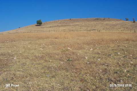
| Location: It lies 5 km of the Çorum-Merzifon motorway at the 30th km; northeast of the Çorum Province. The cemetery stands on the southern ridges of a flat hill located 1.9 km southwest of the village of Haci Yakup (Göller). The village remains between the former and new roads. |
| Geography and Environment: The cemetery is surrounded by low mountains. It has been severely damaged by the local villagers. |
| Destruction Details: The site has been damaged due to illicit diggings [TAYEx 19.8.2003]. |