| ©The Archaeological Settlements of Turkey - TAY Project | ||||||
|
|
||||||
Gölde |
||||||
|
|
||||||
| Ages | Maps | Photos | ||||
| Neolithic |
 |
 |
||||
|
|
||||||
|
Type:
|
Mound | |||||
|
Altitude:
|
1300 m | |||||
|
Diameter:
|
m- Direction: | |||||
|
|
||||||
|
Region:
|
Mediterranean | |||||
|
Province:
|
Burdur | |||||
|
District:
|
Merkez | |||||
|
Village:
|
Yesildag | |||||
|
|
||||||
|
Destruction :
|
Agriculture - Contemporary Settlements | |||||
|
|
||||||
|
TAYEx:
|
Visited - 26/6/2001 | |||||
|
|
||||||
|
Registration State:
|
Registered For detailed registration information please refer to Turkish pages. | |||||
 |
||||||
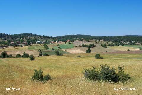
| Location: This site lies approximately 30 km south of the city of Burdur in the village of Yesildag; which used to be called Gölde. |
| Geography and Environment: The mound lies on the southeastern skirts of Mount Kestel; on 1;550 m high Kiziltepe. It lies on a plateau which is surrounded by high mountains. The site lies at the confluence of Bozçay Stream; which springs from the Alagöz Spring and eventually empties into Burdur Lake and Geçdin Stream. Because of the confluence of these streams; the area locally is called the Gölde Watershed. The mound was named by M. Özsait after the old name of the village of Yesildag. |
| Destruction Details: The mound has been damaged due to agricultural activities and contemporary settlement. There are terraced areas at the north and south sections and northeast slope is planted. Houses built on south and southwest slopes [TAYEx 26.6.2001]. |