|
©The Archaeological Settlements of Turkey - TAY Project
|
|
|
|
|
|
Keramos |
|
|
For site maps and drawings please click on the picture... 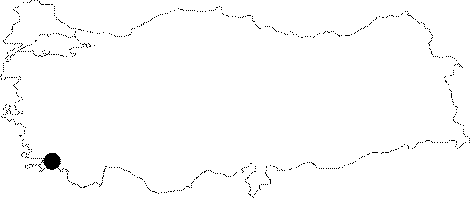 |
For photographs please click on the photo...  |
|
Type:
|
City |
|
Altitude:
|
m |
|
Region:
|
Aegean |
|
Province:
|
Mugla |
|
District:
|
Milas |
|
Village:
|
Ören |
|
Investigation Method:
|
Survey |
|
Period:
|
Archaic Hellenistic Classical Roman |
|
|
|
  |
|
| Location: It is located in the Oren Village of the Milas District; southwest of the Mugla Province. It can be reached from Milas by car within one hour [Tirpan 1989:363]. |
| Geography and Environment: Flowing where the Mountain of Kiran; which is c. 600 m high; allows passage; the Karacay Brook forms a delta leading downward from the plateau. The river originates from the plateau. The water spills into the sea through underground ways. Located on a corner of the alluvial plain deposited by Karacay; it is most likely that Keramos was initially established on the shoreline [Bean 2000:36]. The shore to the west of Keramos is occupied by pebbled beaches interrupted with arable fields. To the east rises the Mountain of Kiran which does not allow passage until Akbük [Bean-Cook 1957:68]. It is known that Keramos; situated between Halikarnassus and Idyma was linked to Stratonikeia by a road passing through Panamara [Tirpan 1989:363]. |
| History: Its Carian origin was elucidated by an inscription from the 4th century BC [Tirpan 1989:363-364]. There is not much about the foundation of the city. She was a member of the Delian League; and she paid a tribute of 1.5 talent [Bean 2000:39]. It is unclear if she was under the dominion of Seleucus or Ptolemaios during the 3rd century BC [Tirpan 1989:364]. First minted in the 2nd century BC; depictions on coins include Zeus Chrysareus; the chief deity of the city; together with a seemingly local god. This young god wearing Khitoniskos and holding a labyrint and a spear; was depicted standing [Bean 2000:39]. The city was under the protection of Rhodes in 189 BC; and then gained her independence in 167 BC. According to an inscription; Keramos had a sympoliteia with another city; which is supposedly Stratonikeia; as it was closer [Bean 2000:38]. The city was included within the Asian Province of Rome in 129 BC [Tirpan 1989:364]. It is known that she had a good relationship with Rhodes. She was punished by giving the city under the control of Stratonikeia in 81 BC as she sided with the king during the Mithridates Battles [Tirpan 1989:364]. The population increased during the Roman Imperial and Byzantine Periods. Inscriptions indicate that a father and son from Keramos were in charge of minting; and another person from Keramos worked as the bishop of the Roman imperial cult as well as an eklogistai for the city of Ephesus [Tirpan 1989:364]. In following periods; Keramos became a religious center under Aphrodisias. |
| Research and Excavation: The first information on the ancient city of Keramos was provided by Wood. During the 19th century; some investigations were carried out by Newton; Paton and Hicks at various periods; after which they particulary published about the inscriptions. Guidi and Maiuri published some articles about the history and buildings of the city. Robert conducted some research in 1932; and published about the inscriptions. Later on; Bean and Cook published general information about the city while Head studied the coins of the city; and Akarca; of the history; buildings and city wall of the city; and Varinlioglu; of the buildings; inscriptions and social life of the city [Tirpan 1989:364-365]. It takes place in the registered archaeological sites list prepared by Ministry of Culture and Tourism. |
| Stratigraphy: |
| Small Finds: |
| Remains: Remains of the ancient city have been extensively destroyed by the local people. There are many Roman and Byzantine buildings with unknown functions. One of them is a small Byzantine church [Bean 2000:42]. The acropolis stands on the Bakicak terrace; which yielded the head of an Archaic statue among the ruins of a temple [Varinlioglu 1980:65]. City wall: The city wall streching to the south by covering both summits of the mountain slope to the north of the city; continues in a regular line to the east and west; but in a semi-circular shape to the south. It was non-preserved in some of the inclining land to the north while partly obscured under the eroded deposits to the south [Tirpan 1989:365-366]. Overall it is a massive wall consisting of two to three stone blocks placed adjacently. Also found is a brick masonry in some parts of the southwestern wall [Tirpan 1989:366-367]. Most part of the walls are made of dark grey limestones and dirty yellow conglomerates. Analysis revealed availability of various types of masonry in the city wall [Tirpan 1989:366]. It was pierced by 13 towers at several places; among them; a total of eight towers on the plain; two to the west; five to the south and one to the east; and a total of five on the hill. The arched gates of the towers open into the city. A total of five gates were found; one to the east; one to the north; one to the west and two to the south; which are all reported to have real arches [Akarca 1998:172]. The road to the harbor passes through the Gate 1; which was made of polygonal and cut stones. The gate is placed inside a knee. One of the walls of the present gendarme building rises on the foundation of the old city wall. The gate protected by the wall top guard measuring 3.6x9.6 m; and the covered hall at the entrance; is similar to the southern gate of Alinda in that sense [Tirpan 1989:370]. The Gate II to the south is the largest one of the city. The city wall turns into a semi-circular form as it gets nearer to the gate. The door is located right in the center of this semi-circle. The two towers at the junction point of the city wall combining with this semi-circle on both sides; including the gate should have fortified the defense of the gate [Tirpan 1989:370-371]. The gate III is located to the southwest of the city. It is arched; and made of breccia stone. The gate IV is located to the southwest of the city as well. To its immediate south lies the best preserved tower of Keramos. The Gate V lies to the north. The city walls of Keramos are dated to 3rd century BC n technical respect [Tirpan 1989:371-372; Tirpan 1990b:224]. Street: It is suggested that the street uncovered in the the north-south direction is the main street of the city [Spanu 1995:136]. Arch: It is located on the main street. It is a simple arch with one entrance. There is no information about its form; to which emperor it was dedicated; or the date of its erection since no excavation took place yet [Spanu 1995:136]. Agora: An area lying to the east of the city; although not certain; was defined as the agora due to its characteristics such as its topographic plan; and location near the harbor. The area is surrounded by walls except on its east side. It is pierced by six gates on the southern wall; with some windows and an opening on the western wall. The north wall has been destructed by modern buildings. But it is presumed that it was originally closed; without any gate. It is also suggested that there were some shops in the north section [Spanu 1995:135-136]. Theater: The regular cracks carved on a rock in a natural valley on the northern slopes of the city indicate the cavea of the theater. An excavation is required [Spanu 1995:136-137]. Gymnasium: It is located right in front of the Agora; on the northern side of the present Cumhuriyet Street. Survey revealed that it consisted of a central courtyard and two symmetrical wings. A room measuring 9.5x12 m; is apsed to the east and the west. Another room measuring 11x25 m; contains five large arches on the longer sides. The building is considered as a structure between the Greek Gymnasium and the Roman Bath; similar to those in Ephesus; Sardes and Alexandria Troas [Spanu 1995:136]. Palaestra: Defined as palaestra by Guidi; it lies to the east of the city. It consists of a square patio of 47x47 m; and a semi-circular apse. Based on its unmortared pseudo-isodomic masonry; it is suggested to have dated back to the Hellenistic Period [Spanu 1995:134]. Bath: It is located to the south of the Nymphaeum. Currently it is surrounded by a modern settlement. It was divided by a road; and now it is being used as a stable. It was built in the opus caementicum technique. Eight rooms and an apse with a preserved domed roof were found in the east. The apsed section is considered to be the calidarium. According to researchers this structure is related to the bath erected for Hierocles and his wife Aristoneike in 2nd century AD; referred in some inscriptions from Keramos [Spanu 1995:135; Ruggieri 2000:384]. Nymphaeum: It is located to the west of the platform where the Zeus Chrysaoreus Temple is situated; on the second terrace below [Bean 2000:40]. The 30 m long structure; which was built on three terraces; was built in the opus caementicum technique. There are five large niches on the first floor; and three large rooms above on the second floor without any cover; and they are overlaid by some rooms with barrel vaults. The water brought by the aqueduct fills up the first room in the west; then fills up the other rooms through a second channel. The large rooms on the second floor should have been used as water tanks. The structure currently called "Bakicak" was presumably a Nymphaeum during the ancient period; and it was suggested that an inscription uncovered in the city from the Traianus period was possibly related to that building; and therefore it might have been dated back to the beginning of the 2nd century AD. It is indicated that as it is unique among all the cities of the Asia Minor and the Eastern Roman States; possibly western architects and workers worked for the construction of this building. The Nymphaeum was presumably founded by Lykiskos; a relative of Hierocles[Spanu 1995:134-135]. Aqueduct: To the north of the city lies a very badly damaged aqueduct; probably fed by the springs at the skirts of the mountain [Bean 2000:42]. Temple/Sanctuary : Zeus Chrysareos Temple: It is located on the Bakicak Hill which is outside the Oren village. Almost no remains survived to our day from the platform on which the temple arises; or the surrounding terrace wall. Thus; no comment can be made on the temple plan or order. But the presence of a labrys relief; which is the symbol of the Carian Zeus on a block uncovered near the temple suggests that the temple was dedicated to Zeus Chrysareos [Bean 2000:40]. The Archaic Curos head found in the environs in 1932 has been already preserved in the Museum of Izmir. Kursunlu Yapi: It is situated about 402.3 m to the east of the city; on the skirts of mountains. Locally called "Kursunlu Yapi"; this heavily damaged temple was built on a platform. It is in Corinthian order [Bean 2000:41]. The two column capitals are from the Justinian Period [Ruggieri 2000:383]. The architecture of the building defined as Public Building by Ruggieri; indicates the the masonry from the Classical Period [Ruggieri 1999:227]. The supporting walls of the temple were decorated with round shield reliefs surrounded by garland ornaments. Among them; one of the inscriptions reads that a monk named Marcus Aurelius Chrysantas also contributed to the construction [Bean 2000:41]. Necropolis/Graves: It is located on the ancient road leading to the port in the southern section. Most of the sarcophagi were made of conglomerate. Some of their tabulas contain inscriptions. There are also monumental graves. There are two more cemeterial areas; one to the east of the city on the road to the sacred area presently called Kursunlu Yapi; and another on the Turkakbasi Hill. Besides; there are two graves to the north of the city wall [Spanu 1995:137]. There are also graves on the roads leading to the city gates [Bean 2000:39]. Building with Unknown Function: There are rooms divided by crossing walls in the area between the terrace wall to the west of the platform and the platform on which the temple arises which is presumed to have belonged to Zeus Chrysareos; and there exists another terrace wall below those rooms. This area is also divided by two crossing walls. There are six large niches on the external surface of the lower terrace wall; and water grooves on the upper terrace wall. The function of this building is yet to discover [Bean 2000:40]. Another structure was named Akyapi. Belonging to the Roman Period; it was converted into a complex with unknown function during the Byzantine Period [Ruggieri 1999:226]. As there are sarcophagi and graves around the niched building; it is presumably related with a hoard. The columns; capitals; and inscription blocks are all scattered around. An ornamented marble fragment indicated the Byzantine Period. An excavation is necessary to confirm if the building is from the Late Roman Period [Ruggieri 2000:383-384]. Miscellaneous: Also found are water depots; small churches and walls of Residences; which are presumably from the Roman Imperial and Byzantine Periods. However; their location indicate an earlier city planning; probably of the Hellenistic Period [Spanu 1995:137]. The torso of the athlete has been already preserved at the Museum of Bodrum. Made of a fine grained white marble; its workmanship resembles the ones in torsos of Miletus and Delos as well as the figures on the Corinthian and Laconian vessels dating to the 6th century BC; and consequently it is dated to the second half of the 6th century BC; possibly around 550-530 BC [Gürman 1974a:49-51]. |
| Interpretation and Dating: |

