|
©The Archaeological Settlements of Turkey - TAY Project
|
|
|
|
|
|
Yumuktepe |
|
|
For site maps and drawings please click on the picture...  |
For photographs please click on the photo... 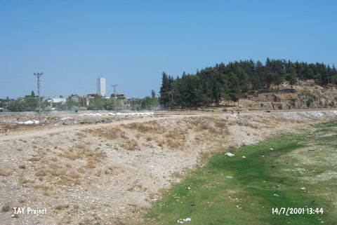 |
|
Type:
|
Mound |
|
Altitude:
|
150 m |
|
Region:
|
Mediterranean |
|
Province:
|
Mersin |
|
District:
|
Merkez |
|
Village:
|
Merkez |
|
Investigation Method:
|
Excavation |
|
Period:
|
Late Iron Age |
|
|
|
 |
|
| Location: This site lies approximately 3.5 km west-northwest of the city of Mersin; along the major highway heading west from the city. Since the city has grown; the site now lies in the Demirtas neighborhood and looks more like a park or picnic area than a mound. |
| Geography and Environment: The 25 m high mound lies on the southern bank of the Soguksu (Müftüderesi) Stream. The site has a 300 m diameter and covers a 12 hectare area. Although the Department of Monuments and Museums has declared this site as a protected historical area; it has been turned into a park and trees have been planted. The western part of the mound has been eroded by the flooding of the Soguksu Stream. Although the mound was originally called Yümüktepe; this name has been changed to Yumuktepe; as it is the name that the local villagers use to refer to the site. In addition; there are many archaeological publications that refer to this site as Mersin or Mersin Soguksutepe. |
| History: |
| Research and Excavation: It was discovered in 1936 by J. Garstang who conducted excavations in the site between 1937-39 and 1947-48. These excavations were accompanied by many well-known scientists such as S. Lloyd, R.D. Barnett, M.V. Seton-Williams, O. Gurney, and G. Childe. The excavations were resumed in 1993 by a team under the direction of the Directorate of the Mersin Museum, and since 1994 by a team of the Istanbul and Rome Universities under the direction of V. Sevin of the Prehistory Department of Istanbul University, and with contribution of I. Caneva of La Sapienza University in Rome. The objective of the second campaign was to define the borders of the Yumuktepe settlement, and then to enclose the site and turn it into an open-air archaeological park. The plan is to have a stepped exhibition of the restored building elements in their historical order so that the visitors will be able to follow the cultural development of the site as an open-air museum. The Sevin-Caneva excavations focused on the validation of the Garstang's stratification through use of new research systems and modern technological equipments. The project is expected to continue for a long time. The salvage excavations which were started in 1993 continue under the direction of I. Caneva, and Yumuktepe has been entirely taken under conservation [Sevin 2003c:55-56]. |
| Stratigraphy: The stratigraphy of this important mound in Çukurova (Cilicia) served as an important bridge, particularly in the cultural relationship between Mesopotamia-Northern Syria and Southern Anatolia. A total of 33 levels were identified during the excavations directed by Garstang. The new and ongoing excavations since 1993 have focused on validation and restructuring this stratification. The uppermost level contains remains of fortifications, presumably enclosing the Byzantine Period settlement. It is followed by an Iron Age building level (Level III) also known from the trenches on top of the mound. This level was dated to the 7-6.th century BC. Traces of Late Bronze Age were observed below the Iron Age level in 1998. The squares L 11-12-13 and the adjacent M 11-12-13 were first excavated in 2006. Analyses on on the southern and eastern cross-sections in the entire excavation area showed that the Iron Age levels are very close to the surface in this section. The above mentioned trenches, which were opened without any walk-ways in between, revealed a very heavy destruction due to the French military camp during the WWI and construction of a cafeteria in 1980s. |
| Small Finds: Architecture: The pebble paved road unearthed in the trenches on the western section of the mound's peak, which has been leveled, was dated to the Iron Age. The first data concerning the earlier periods of Iron Age was obtained from the grid-squares N11, O11 and N12. The trenches to the immediate east of the fortification wall remains (O11, N11) from the Middle Age enclosing the top of the mound yielded foundations of two buildings adjacent to this wall on the top. A northwest-southeast oriented wall strecthing in parallel to the fortification wall was connected with the fortification wall by two vertical dividing walls. Under this wall in grid-square O11 starts the level with the Iron Age ceramic assemblage. During the efforts spent for reaching to the same level at the entire trench N12, a pavement composed of compressed sherds and animal bones was found [Caneva et al. 2005:207]. The grid-squares M 20, 21 and 22 on the eastern slope of the mound were excavated during the 2004 and 2005 campaigns in order to examine the levels related with the Iron Age; and some architectural elements made of rounded cobbles related with the Iron and Bronze Ages were unearthed. The grid- squares L 11-12-13 and the adjacent M 11-12-13 which were excavated in 2006 also yielded Iron Age architecture. Remains of two long walls, 5 m in lenght and 1.5 m apart were identified right below the surface in trenches L 11 and 12. Among the stones of the wall are rubble stones and rectangular cut stones as well as re-used building elements such as columns, pillars and pedestals. In grid-square L 13 also found is an area used as a hearth composed of two rectangular stones placed side-by-side and a horizontal stone on top as suggested from the ash coal remains. However, no regular floor remains were unearthed here despite detailed work in this extensive area. Fragments of compressed floor with lime mortar or pebble pavements were identified in smaller areas. Excavations continued in 2006 on top of the mound in stepped grid-square M20, which measures 4x5 m. A depth of 30 cm below the surface level was reached, and although the floor of the Iron Age deposit was not reached, a mixed assemblage of this period was unearthed [Köroglu 2007]. Pottery: The 50 cm thick deposit which was excavated from the exterior surface of the fortification wall down to the pebble deposit on the floor yielded mainly sherds of the painted Iron Age pottery [Sevin 2001b:96]. Another level starts under the walls at grid-squares O11 and N11, providing an Iron Age pottery assemblage [Caneva 1996:71-81]. The pavement composed of compressed sherds and animal bones in grid-square N12 yielded paint banded bowls, amphora handles, crater rims and necks decorated with wave and plant motifs on their neck from the latest phase of the Iron Age [Caneva et al. 2005:207]. Kitchenware for daily use were found in grid-square M 20. Among them are vessels with horizontal grooves on the exterior and whose rims were thickened out as a band. A majority of the ceramics consist of the sherds of the red figure wares from the Late Iron Age and Classical Period. Among other finds are Cypriote wares with concentric circles, first fragments of black burnished carinated vessel with an everting rim imitating metallic ware and fragments of painted band decorated and black burnished wares dating to the mid-6th and 5th centuries [Köroglu 2007]. |
| Remains: |
| Interpretation and Dating: |