|
©The Archaeological Settlements of Turkey - TAY Project
|
|
|
|
|
|
Altin Tepe |
|
|
For site maps and drawings please click on the picture...  |
For photographs please click on the photo... 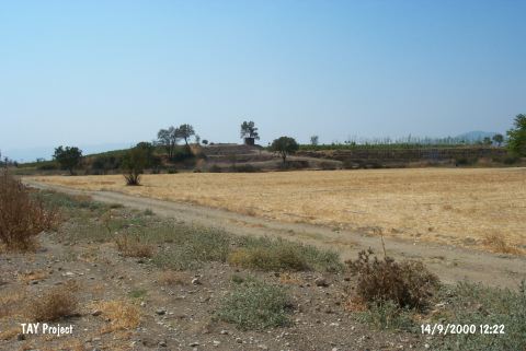 |
|
Type:
|
Mound |
|
Altitude:
|
100 m |
|
Region:
|
Aegean |
|
Province:
|
Izmir |
|
District:
|
Menderes |
|
Village:
|
Merkez |
|
Investigation Method:
|
Survey |
|
Period:
|
|
|
|
|
 |
|
| It lies on a low ridge on the western bank of the Bulgurca Brook. The deposit of the mound is ca. 6 m thick. To the immediate east runs the Izmir-Aydin railway. It stretches in the east-west direction with a profile becoming steeper to the east, and ending at the railway. Sherds and slags are observed on this steep slope. Particularly rich material from the 3rd Millennum BC including stone tools are found on the lower sections of the eastern slope, the finds spreading onto an area more than ca. 25 acres. The surface material from the Iron Age are more frequent on the plain ground to the west [Tuna 1986: 215]. |
| Location: It is located northwest of Torbali; 3 km southeast of the Cumaovasi District as the crow flies; south of the Izmir Province. The Izmir-Aydin railway is 80 m east of the mound. Code R 5/11. |
| Geography and Environment: The Tahtali Stream (also known as Bulgurca) formed by the Degirmen and Delibogan streams joining on the north of the mound flows to the east of the mound. The mound stands on a low ridge in a narrow valley. The cultural deposit of the mound is ca. 6 m thick. It has a vertical section extending in the east-west direction [Kaptan 1999:fig.1]. The settlement is ca. 10 ha. wide. The mound is a vineyard at present. |
| History: |
| Research and Excavation: |
| Stratigraphy: |
| Small Finds: |
| Remains: |
| Interpretation and Dating: |