|
©The Archaeological Settlements of Turkey - TAY Project
|
|
|
|
|
|
Degirmenözü |
|
|
For site maps and drawings please click on the picture...  |
For photographs please click on the photo... 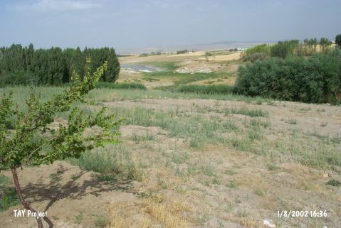 |
|
Type:
|
Mound |
|
Altitude:
|
1155 m |
|
Region:
|
Central Anatolia |
|
Province:
|
Aksaray |
|
District:
|
Ortaköy |
|
Village:
|
Gökleryaylasi |
|
Investigation Method:
|
Survey |
|
Period:
|
|
|
|
|
 |
|
| The mound; located at the center of a narrow valley; lies in Degirmenözü Mevkii of Gökler Village; 5 km northeast of Ortaköy District of Aksaray Province. It was visited by I. Todd in 1996; by S. Omura in 1990. According to them; the ceramics and the dominant obsidians date to the NA and EBA (Harmankaya et al. 1997:Degirmenözü]. On the contrary; Summers [Summers 1993:30] claims that Degirmenözü is one of the Chalcolithic Age settlements of Central Anatolia. |
| Location: This site lies in Degirmenözü Mevkii of Gökler Village; 5 km northeast of Ortaköy District of Aksaray Province. |
| Geography and Environment: Todd describes Degirmenözü as a low mound along the skirts of a natural hill [Todd 1980:40]. Except for a nearby stream; there are no fresh water sources in the site's vicinity today. In 1966; when the site was surveyed; it was under cultivation. The narrow valley that the site lies in is bounded by mountains. |
| History: |
| Research and Excavation: |
| Stratigraphy: |
| Small Finds: |
| Remains: |
| Interpretation and Dating: |