|
©The Archaeological Settlements of Turkey - TAY Project
|
|
|
|
|
|
Pedasa |
|
|
For site maps and drawings please click on the picture... 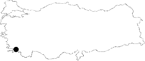 |
For photographs please click on the photo...  |
|
Type:
|
City |
|
Altitude:
|
m |
|
Region:
|
Aegean |
|
Province:
|
Mugla |
|
District:
|
Milas |
|
Village:
|
Gökçeler |
|
Investigation Method:
|
Excavation |
|
Period:
|
Protogeometric Geometric Archaic Classical Hellenistic Roman |
|
|
|
  |
|
| Location: It is located in the Gokceler Village to the north of the Bodrum District of the Mugla Province [Bean 2000:115-116]. It is close to the village of Cirkan [Bean-Cook 1955:123]. |
| Geography and Environment: Situated in front of a narrow passage; it is reported to have been covered with pine trees during the researches carried out at the mid-20th century [Bean 2000:116]. The area stretching from the north of Goktepe and Konacik to the Torba port was presumably within the borders of the ancient city of Pedasa. Many Lelegian structures were found during the researches [Diler 2003:14-15]. |
| History: In the Book 1; 175-176 by Herodotus; it reads that the Pedasians resisted against the Persians who defeated Lydians in 546 BC; and hided at the Lida Mountain for a while to give them some trouble. Today; it is believed that Kaplandagi or Tirmandagi was the Mountain of Lida. Herodotus also informs that the priestess of Athena grew beard when any disasters were eminent in Pedasa; and that it happened three times. It is significant that Pedasa was the only Carian city that showed resistance to the Persians in the 6th century BC. Pedasa was paying two talents to the Delian League; and then started to pay one talent. The Carians who were defeated by the Persians during the Ionian Revolt in 499 BC ambushed the Persians on the road to Pedasa. The Persians; after capturing Miletus in 494 BC; forced the Pedasians move to the hills above Miletus. Based on the archaeological data; it seems that the city had not been completely abandoned. It was probably used as a military camp by Philip V between the end of the 3rd century BC and the beginning of the 2nd century BC [Bean-Cook 1955:124-125; Bean 2000:115-116]. The potsherds and fragments of bricks dating from the Hellenistic and Roman Periods reveal that the city was probably inhabited during these periods; and Pedasa was under the influence of Hellenization since the Period of Hecatomnids [Diler 2003:15]. |
| Research and Excavation: Paton and Myres carried out several researches in the city at the end of the 19th century; and Maiuri in the 1920's; while Bean and Cook conducted surveys in 1950's. Archaeological excavations restarted in 2007 in order to support the data obtained from the surveys by A. Diler et al. between 1999-2006 through excavations. |
| Stratigraphy: |
| Small Finds: |
| Remains: The 160 m long fortress was built on an a small hill looking like an acropolis [Bean 1955:123-124]. To the south of the territory of Pedasa; at the Hamasa Mevkii are remains of houses restricted by an enclosing wall and animal shelters; which have been recently used as borders for fields and sheep-fold. And to the south of the Hamasa Mevkii; a threshold block; presumably of a monumental building; and some architectural elements in its neighbourhood as well as unplastered and undecorated locally produced coarse sherds; probably from the Archaic Period were uncovered [Diler 2004:144]. Further to the north; there is a structure measuring 24x13 m; extending in the east-west direction; surrounded by a wall of 75-80 cm wide. The walls were built of horizontal stones in the Lelegian style. It was presumably used as a residence. The scientific excavations which were previously started by A. Diler et al. were resumed at the acropolis in 2007. It was found that the building named "Administrative Building" rising above the natural rock massive was originally megaron planned. Sturdiness played an important role in the construction of the external walls surrounding the M-1 and M-2 rooms of the "Administrative Building" which were early phase walls. The stones inside were not retouched elaborately and were almost left untouched. This suggests that the walls were built to give an impression of sturdiness. In both rooms the sherds of the vessels which were routinely used in the daily life found during the removal of the stone deposits, Byzantine Period green slipware, roof tile sherds and grindstone fragments were found. A large pithos was found in situ on the ground level of the room M1. Although the main rooms of the administrative building contains intense Byzantine Period finds, the presence of ceramics finds such as Early Archaic Period limestone statuette, and Archaic Period pithos fragment suggests that the building originated in early period phases and survived to date [Diler et al. 2009:267-269]. A furnace was encountered in the north corner of the room identified as M-9 during the researches on Acropolis. The upper cover of the room consists of a vault and its floor consists of marble plates. The area did not display a room plan and was named M-8, it is assumed that it is a side street [Diler et al. 2009:269]. During the excavations held in 2008 and 2009 general information on the settlement at Acropolis is obtained. Islands of buildings are encountered that are designed in adjacent manner, i.e. constructed one next to the other. Between 1.5 and 2.5 m wide streets cross islands of buildings. When the remains which are connected via joints are excavated up to the city wall, it became possible to interpret the early and late period's architectures. Considering the workmanship of the walls in the excavated areas, it is found interesting that almost all buildings are made of rough stones and smaller rectangular stones and that the entrances of the buildings are shut with large blocks of stones. It is evident that room 37 and room 38 in the West are designed as a single room. The West wall of Room 37 is quite thin. This thickness difference on the West wall -0.40 m thick- is because of the internal dividing function of the wall. Two rooms are constructed between the city walls by this dividing wall. A 0.20 m thick wall is constructed between these two rooms and the city wall. This wall is used as a dividing wall and made of a single row of stones. The stones on the base are produced with good workmanship and placed closely. Room 38 has a closed entrance and a triangular plan including the corner of the city wall. The dividing walls of these rooms are probably not very high and the rooms are accessed by internal stairs. The original entrance of the structure is from the Northwest corner which opens to Street 2. This opening is shut later. On the corner where the shut entrance resides a curved corner is constructed. This building has a higher basement compared with the similar structures that are excavated in the same area. Its floor is paved with regular slate stones. The upper surface of this curved room is elevated by 1 row of stones and routed to an open area of 0.18 by 0.10 m. This slope is routed to the open area which is fact that suggests that it may be used for bathing purposes. Stair platforms are encountered on the streets in the field. These platforms are used for climbing to the living areas above the depot rooms. The best reserved stair platform is the one in front of the Room 39 on the street and in line with the city wall [Diler (Ö. Baran) 2011: 325-326]. During the studies carried out in Acropolis in 2012, the walls dated to Byzantine Period were unearthed. At the bottom of these walls, a great number of potsherds belonging to Archaic Period were revealed [Diler et al. 2014]. In 2013, the studies carried out in the north of the entrance of the southeast rampart of Acropolis. In this area, eight rooms and a courtyard related to these rooms were exposed. Then, it is revealed that these eight rooms was in fact a complex opening a shared courtyard. It is determined that the first phases of Room no.46, 50-51 and 52-52 were single storied. In the second phase, these rooms became two-storied. The ground floors were used as store house or workshop in the second phase. It is suggested that these rooms were became dwellings of Byzantine Period in their last phase dated to the mid 12th century AD [Diler et al. 2015]. City Wall: The acropolis of Pedasa is surrounded by two ring-type walls [Diler 2003:15]. The southern wall is pierced by towers and bastions while the northern and southern sections are in the Lelegian style; stretching by making wide curves. The fortress wall is approximately 1.5 m wide; built by a coarse masonry. The 2.5 m wide main gate lies to the west. There is a 60 cm large postern to the north [Bean-Cook 1955:123-124]. The area to the south of the fortress is also surrounded by a second wall; which is 1.63 m wide erected with dry stone technique; and supported by towers. The towers were built by a fine masonry [Bean-Cook 1955:124-125; Diler 2003:15; Bean 2000:117]. There is a bastion accessed by a ramp and protected by a watchtower; located on the higher east side of the land. It is accessed through a 2.50 m wide gate to the west. Stairways were found at one corner of the tower. Very few potsherds were uncovered from the fortress [Bean-Cook 1955:124-125]. The city walls and the gates that were placed inside these walls were researched during the Bodrum Peninsula Leleg Settlements Research performed by A. Diler et al. in 2006 and 2007. As a result of the research two gates were observed on the south city walls, and one on the west wall. The main gate of the fortress is on the west side and it was built rather in a monumental style compared to others. The remains are 2 m wide and 4.30 m deep and protected by narrow fortification in the front. The other gates were made narrower possibly considering the advantages during a battle. The gates made inside the south and north walls were built in a later period based on their masonry technique and bear traces of repairs. Based on the researches on the south gate the upper lintel contains an inscription on its surface facing downwards. The etniko's inscription which is on the stone block 0.95 m long and 0.18 m high, and is illegible due to destruction belongs to 3rd century BC and has a honorary context [Diler et al. 2009:125-126]. Surface cleaning is carried out on West Gate and excavations are carried out in South Gate in 2009. The West gate is constructed on a location where the surface is lower. The structure of the gate is simple and is made of a 6.3 m long corridor behind the entrance. The corridor is surrounded by two walls reaching in East-West direction. The stones of corridor walls and the West Acropolis walls are constructed in a nested structure. Here the Acropolis wall is made of large blocks of stone, without mortar and with great care. On the contrary the corridor walls are made of various size stones and reflect good workmanship only partially. Gathered material and mortar is also encountered between the blocks of wall. Rough workmanship applied on the wall, the lower rows of city walls of Acropolis, the gathered stones on the gate corridor walls and the use of mortar are the facts that suggest that the age of the West Gate is greater than the first structure in Acropolis. The South Gate is positioned on a high rock of Acropolis' hill overlooking the Sacred Area and the entrance road of the city. The city wall makes a North turn on the entrance and constitute the entrance beams. Another wall rests on the East beam and the lower row of stones of this wall is also made of large blocks. The wall turns North and constitutes a narrow corridor with the entrance wall. 5 rooms are unearthed during the excavations carried around this corridor [Diler (B. Kleine-I. Mittag-A. Wienkemeier) 2011: 327-328]. Temple/Sanctuary: The Temple of Athena: Known from the ancient resources; it is located at the city entrance. It was built with a bossed isodomic technique; probably during the Hellenistic Period. It was destructed by the illicit diggings; a grave or a bothros was found; and the material uncovered were dated to the Late Archaic - Early Classical Period [Diler 2003:15]. The scientific excavations performed in the area named "Athena Temple" in 2007 revealed the original wall. The building lies in north-south direction, which is divided into three sections; in the north it is divided by a wall in east-west direction; in the south there is a wall that divides the building in north-south direction. The entire building measures 12x8 m. Based on the masonry and the finds that were revealed the building was built during Mausollos Period, it probably was related with Mausollos' Synoecism Politics therefore it was used for military purposes for the control of city gates [Diler et al. 2009:270-272]. 2009 excavations are concentrated on the area above the building named as "The Outpost Building" which is constructed with bossaged steady blocks. The architecture building elements from archaic period and the findings which can be interpreted as sacrificial goods are the first precursors of the existence of a sacred area in this field. The monumental structures in the sacred area are resident in the upper terrace which is surrounded by the main rock in the North. The piece scripture with the name of the goddess, a piece of Athena sculpture portrayed with Aegisi and the baked female figurines are among the information which proves that this sacred place belonged to Goddess Athena which is mentioned in Herodotus [Diler (H. Bulut) 2011: 329]. In 2010, the studies in the terrace of the temple were carried out at the southwest corner where the west and the south podium walls intersect. It was discovered that the flooring was continued towards the south and the east and it has two phases. The flooring was used together with the mortar and the architectural units belonging to the early phase structures in the terrace. On the west of the square shaped altar which was exposed in 2009, two pits which could be identified as bothros were exposed. The pits are located on the bedrock. Cylindrical shaped pit measuring 0.80 m in diameter and 0.85 m in depth yielded animal bones, seashells and large amount of ash [Diler (H. Bulut) 2012:171]. Although the soil deposit piled up by the illicit diggers on the area named the "Sacred Place" just northwest of the Outpost Building was not entirely cleared, some of the causes related with the structuring of the area were found out. A room possibly related with the latest building phase about 3.40x2.72 m in dimensions delimited by walls mortared with soil, was partially revealed. A second room measuring 3.56x3.47 m delimited by soil mortared reused building blocks is situated north of the first one. The fact that the wall rises on the floor on the north edge, that it is a wide wall and contains a thick inner filling with stones inside, suggests tha tthe wall belongs to a monumental building, possibly an altar. Among the finds collected on the entire site and besides Archaic Period finds, there are black firnissed specimens, Hellenistic Period molding fragments, that belong to 4th century BC, in addition to the bowl and terra-cotta figurine sherds, Byzantine Period slipped ware and glass bracelet fragments. The elaborately worked wall stones used on Byzantine Period walls, ovolo and architectural elements from different buildings and the finds identified as votive items are among the data that could suggest that Athena Altar was in this area along with the data provided by Herodotus [Diler et al. 2009:273-274]. The sounding excavations carried out in the western terrace wall of Sanctuary in 2013 show that the western terrace wall was built after the mid 4th century BC (maybe the third quarter of the century) like in the east. The dressed rock extension forming the north border of the trench should belong to Archaic Period. The fills yielded a large number of potsherds dated to the 4th century BC. The fact that the majority of Classical Period finds belong to the first half of 4th century BC indicates that the Sanctuary was densely used in this period. After the construction of the wall was finished, these finds were used as filling material. A tile figurine fragment belonging to the end of 7th century BC and the first half of 6th century BC was recovered from the terrace fill. The hair of this figurine, which was probably used as votive figurine, is arranged in Hathor-style. In the Outpost Building located in the east of the Sanctuary, the north section called Room 3 was excavated. A wall erected with spolia blocks was exposed in the center of the room. The wall extends in the north-south direction. This wall divides the room into two sections. A storage area belonging to Byzantine Period was found in the room. Potsherds dated to earlier period were exposed below the Byzantine floor. Among these sherds, Attic black firnished vessels are common. The original wall and entrance of Room 3 have not been determined. Therefore, it is not known how the internal features of this room were arranged during the early phases. The structure underwent a change during the late phases. Potsherds indicate that the structure was built in Mausolus Period or afterwards. It was probably used in Hellenistic Period as well [Diler et al. 2015]. In 2014, the studies were carried out in the terrace of the sanctuary. The studies were also conducted to determine the date of the podium wall surrounding the area from the south and west. A sounding was carried out in the west side of Room 12 that is one of the Middle East Roman Period structures. The room was built with spolia temple blocks and the outer face of the west and south walls shows good craftsmanship. There are traces of mortar that was applied in East Roman Period on the walls and different masonry techniques indicate renovations. The wall sits on the bedrock cavity that was filled with red colored earth containing large stones and bedrock flakes. The Corinthian potsherds, Ionian bowl sherds, faience figurine fragments, and faience beads found in the red soil fill between the filling stones indicate that the wall was built in the second half of the 7th century BC and the beginning of the 6th century BC. In the southern half of the sounding area, the ashy and gritty area in front of the west wall yielded a great number of sea scallop shells and a cluster of 12 bronze East Roman folles. Also, East Roman coins and bracelet fragments made out of colored glass and Archaic/Hellenistic potsherds, iron slags and bone fragments were found. The silver Halikarnassos coin, the front face of which depicts Apollon with a bay wreath and the back face depicts with Zeus Labraundos, found in layer 10 in the northern half of the sounding area shows the existence of the finds dated to Hekatomnid Period. At the end of the sounding studies, a neck sherd belonging to an oinokhoe and a body sherd of a Corinthian aryballos with a badly preserved goat depiction were found and dated to the 7th century BC. The imported vessels provide an evidence of the communication with the overseas regions. The sounding conducted in the middle terrace of the sanctuary aimed to collect more data from the areas that were studied in 2009 and 2013 soundings. The south of the sanctuary is bordered with a well-preserved terrace wall that was built in the second half of the 4th century BC. Since the area is very steep in the south-north direction, it was necessary to renovate the terrace walls that have been used since Early IA. This area is not fully studied yet. Therefore, it is not yet possible to get safe information about the building date of the terrace wall. The scattered wall stones and a large architectural block used in the rendering plant found on the surface of the excavated area show the destruction on the middle terrace wall. Actually, this destruction is caused by illicit diggings and because of these activities, the architectural block and finds dated to Archaic, Classical, Hellenistic and Roman periods were mixed. It is noteworthy that the area in the south of the terrace wall was preserved without any arrangement until the mid 6th century BC and even though it is close to the terrace, it wasn't arranged. The excavations were carried out in front of the large terrace in order to understand the architectural integrity of the area. To the south in the direction of the south wall of the Outpost Building, some stones resembling the stones of the terrace wall were found on the surface. As a result of the excavations, it is found out that the original terrace wall stones were built with smaller rubble stones [Diler et al. 2016:560-566]. Domestic Area: The walls built adjacent to the city wall belong to the residential structures. This adjacent plan is typical of the Lelegian architecture [Diler 2003:15; Bean 2000:117]. During the excavations carried out in the East Area 1 of Gökçeler Mevkii in 2012, a rectangular planned building complex was exposed. The long sides of the complex measure 15.30 m and the short sides are about 6.70 m. This building complex was divided into two dwelling areas by a wall with a length of 9.16 m. 6 rooms in total were exposed and it is believed that these rooms were used as dwelling. The rooms extend in the north-south direction. They aligned side by side. This building complex is dated to Archaic Period. The studies carried out in Topçular Hill located in the territory of Pedasa in 2011 indicate the existence of a local settlement consisted of several rooms connected to each other and farmsteads that possibly was surrounded by a city wall. It is believed that this settlement was inhabited from the 7th century BC to Byzantine Period [Diler et al. 2014]. In 2014, the excavations were conducted in the Outpost Building. The building is located about 200 m west of the Acropolis, in the southeast of the Sanctuary. The walls of the building were built in bossage-isodomic technique. It consists of 3 sections. The excavations were conducted in Room 1 and Room 2 in order to determine the function of the building. The entrance on the south side of the east wall of Room 1, which was closed in the late period, was cleaned. This door opens to the sanctuary. Irregular pavement stones were found in the middle section of the east wall. In the destroyed area, tile fragments scattered below the pavement were determined. In this area, black varnished Attic pottery sherds and a Late Classical lamp sherd. The foundations of the building are more coarse and larger in comparison to the upper walls. The foundation walls protrude outwards and this makes the building became more robust. The walls of the outer south section of the building were built in connection with each other. These were built with neatly worked architectural blocks of the sanctuary. The excavations were also conducted in the area called Acropolis Citadel with Tower/Ruler House. The area, which is located in the eastern edge at the highest point of the citadel, is bordered with city walls from the east and south, twin towers from the west, and terrace rampart from the north. This area has never been excavated before. The aim of the studies carried out in this area is to examine the architectural relationship between the citadel and acropolis in a temporal and functional manner. Five spaces were exposed in the continuation of the wall that shows good craftsmanship in the west of the east city wall. These spaces were divided by a street due to the trenches extending towards the west were merged. As in the whole acropolis, this area was also inhabited in the Middle East Roman Period. However, the careless buildings took the place of the well-built structures. In the southeast of Room 1, the preserved stones at the foundation level and the joints show that the original plan of the structure maintained. Room 3 measuring 3.06x3.50 m exhibits a typical East Roman house tradition with its storerooms at the back of the wall and the living areas and the door openings in the front. A few potsherds could be dated to the 4th century BC. Based on the sherds, the area is dated back to Late Geometric Period. Four more spaces extending from the tower towards the north were also detected. Thus, it is almost clear that the original plan of the citadel consists of the rooms aligned side by side the doors of which open to the street. Apart from these, it is determined that a great number of animal bones recovered from the spaces mainly constitute sheep and goats, cattle, equid, boar, canidae, rodentia and marine animals. The butchery activities of sheep and goat show that these animals were kept for consuming. In addition to this, cattle and boar were also related to food consumption. During the excavations carried out in Sivri Çam Tepesi in 2013, remains of civil buildings belonging to earlier period were exposed. Building 1 is located to the southwest corner of the hill. Only the foundation of it was preserved. There are tumuli and burial platform around it. The building is in rectangular plan and it measures 6.40x4.80 m. An illicit digging pit was found in the center of the building. No traces of an entrance were determined. Inside the building, traces of ash were found. There are traces of burn on the inner surfaces of the walls as well. The densely burnt fill in the center of the building yielded phalanxes of human. The studies show that the building could have been used as crematorium. Building 2 located in the north of Building 1 measures 5.60x3.80 m. Ot is rectangular plan. Only the foundation of it was preserved. The building yielded potsherds, loom weights, spindle whorls and burnt wooden pieces. The finds suggest that the building was used as a weaving workshop. In Göktepe mevkii in the west of the territory of Pedasa, remains of three buildings were exposed. Two of them are rounded farmsteads seen in Lelegian settlements in Bodrum Peninsula. The walls of the building were erected in dry wall technique. Building groups, foundations of which are preserved, were found between two farmsteads [Diler et al. 2015]. Remains belonging to 10 structures were determined in Torba that is within the territory of Pedasa. The majority of them are remains of farmhouses. They were built in the Lelegian style drystone wall technique. The structures are in a round and rectangular plan. The number of rooms could be determined in some of them. There is an arched hearth in the farm on the western slope of Arapyurdu Hill. A tower built with well-dressed stones is on the summit of the hill in the north of Fincan Kayasi. Located to Saatçinin Tepesi and Demir Tepe, the structures were encircled by walls. It is registered in the Cultural Inventory of Mugla Province [Mugla KE III.2 2013: 1297-9; 1319-26]. Necropolis/Graves: Most of the burials found to the south and southwest of the fortress are tholoi; Lelegian type of graves. Also found are very few sarcophagi. In tholos; a dromos leads into the burial chamber covered by a corbelling vault. After the burial chamber was enclosed by a circular wall; it was again closed with a circular pile of stones. This way the graves looked like kind of a heroon or a monumental structure. A cylindrical seal with a depiction of a figure holding a spear and hunting a wild goat and a deer; a tripodal single-handled terra cotta vessel; and potsherds from the Protogeometrical Period were uncovered from a burial 15 m in diameter; and 3 m in height situated to the west of the Sivricam Hill; south of the Pedasa Acropolis. The cylindrical seal is compared to the samples found in the Near East at the second half of the 2nd century BC [Diler 2003:15-16]. Similar graves were found on the southeastern slopes. The potsherds uncovered are dated to the Early Archaic Period [Bean 1976:682; Bean 2000:117-118]. 2006 ve Rectangular residences were identified near the tumuli, and the remains, at Üç Örenler location on the hill northwest of the acropolis, during the Bodrum Peninsula Leleg Settlements researches performed by A. Diler et al. in 2007. It has close relations with the Mycenaen burials that were revealed inside the settlements such as Müsgebi which has characteristics such as inhumation and cremation besides the narrowness and low height of the dromoi, and particularly the near square rectangular plans of the burial rooms of Pedasa's Late Protogteometrical and Geometric Period tumuli [Diler et al. 2009:125-126]. During the excavations that started in 2007 excavations and cleaning were performed on Çam Hill and two of the tumuli near it, located inside the Southeast Necropolis, which were almost entirely looted following illicit diggings. A small portion of the round surrounding wall was preserved in the northwest section of the Tumulus I. The dromos measuring 0.74 m wide, which provides the access into the burial room that measures 2.90x2.33 m on the basin that lies in east-west direction is located on the west wall of the burial room. The bedrock lies on a flatter basin in the southwest section of the burial room. There is a pit in the northwest corner that measures 1.23x0.80x0.25 m which was composed by digging the bedrock. The presence of a terra cotta sarcophagus' basin and sidal parts inside the above mentioned pit inside the bedrock suggests that theis pit was dug for placing a sarcophagus inside. The south section of the krepis wall that surrounds the Tumulus 2 is underneath the stonen deposit. It is a mid size tumulus with a surrounding wall diameter of 11.70 m. The east and south burial room walls are almost intact up to the level of the ceiling. the north and west walls were destroyed. Among the finds collected at tumuli 1 and 2 the terra cotta sarcophagus fragments proves the burial placement tradition was common during 7th century BC and before [Diler et al. 2009:274-276]. Due to the easy visibility of the burial lids placed inside the platforms at the West Necropolis these were destroyed by treasure hunters. 3 burial pits were revealed inside the better preserved burial #1. The burial #1 was placed on the northeast edge of the platform in east-west direction. The burial lids that cover the west side of the burial pit were placed in opposing direcitons and were composed of plates placed on top of each other. The soil deposit that bear a large amount of pithos fragments found during the researches inside the burial pit continued down to the level of the bedrock surface. The small monochromatic amphora and the bronze fibula fragment left inside the burial #1 although destroyed by smugglers, suggest the variety of the burial gifts. The researches performed on the burials 2-3 and 5, showed that all three burials were used as urns. A small handmade amphora was found inside the burial #2, a bronze fibula fragment inside burial #3, a spindl whorl and a ring-formed bronze loop were found inside burial #5. Although it is hard to suggest a certain date for the finds similar specimens of the basic local forms were observed in Submycenaen Period and Protogeometric Period, thus the burial platforms have burial gifts similar to and contemporary of the tumuli. The Urna pits were rather built narrow and high. It is unclear whether each of the pits is a cinder storage area on its own. Based on the 2007 research results the presence of the inhumation and cremation burial tradition at Pedasa during the Late 2nd Millenium BC and its continuity for a long time throughout the Archaic Period makes the traceability of the burial tradition possible on the Leleg peninsula, thus making Pedasa an important archaeological settlement [Diler et al. 2009:276-278]. The data obtained from the 2 grave platforms excavated in 2008 and 2009 show that the grave pits are used once for urn burials. The graves have similar features such as being opened in the stone embankment, having much larger lids compared to the grave pits, having rectangular pits, having ashes and burnt bone pieces on their bases, and not containing any grave presents. Pithos burials are also observed in grave platforms though rarely. A monochrome skyphos probably from Protogeometric Period that is captured in the Northwest of Grave 6 from the platform of Grave 1 proves the existence of tradition placing the burial present near the lid inside the stone embankment. Pieces of pottery -mainly skyphos- encountered in and on the stone embankment of grave platforms must be evidences of visits to the cemetery and of urn burials. Among the gifts captured in the graves are monochrome vessels, fibulas, spindle whorls, iron sword pieces [Diler (B. Özer) 2011: 331332]. The grave monument named as "Gebe Church" which is in the Northeast of city territorium, in the Southwest of the modern Torba settlement is surrounded by walls except the West. The grave chamber is 2.95 m long in all directions. Based on the analysis of the pottery pieces inside it is estimated that the monument is built during Early 6th Century [Diler (B. Özer) 2011:332]. The 2010 excavations where carried out the area where the damaged cist graves are located, about 30 m south of the outer wall, on the lower south slope of Acropolis. There 2 rooms related with the same structure and the graves where placed on the west side of the Room 1 which is the one on the north. The graves in E-W direction extends from south to north. These cist graves where covered the western half of the structure and placed by spacing 1.50 m at the east corner of the structure. 3 burial chambers where formed with two party walls. The south and the west walls of the grave numbered 1 were formed by erecting walls with a single course of stones. The upper parts of the graves were covered with large stone slabs. Over these stone slabs, there is a second stone arrangement formed with smal flat stones. A skeleton which indicates the earlier phase of the grave was encountered at lower elevations. The skull of the skeleton locates to the east side. The graves 2 and 3 bear similar characteristics with the grave 1 in terms of their quadrangular shaped plans, deepness and wall masonry. During the studies carried out in the grave 2, skeletal remains and an unguentarium which is thought to be a burial gift belonging to the mid 2th century BC. were recovered at the northeast corner. A channel which is probably related with the time when the structure was used as a dwelling was found in the middle section of the grave. The channel measures 0.15 m in width, 0.20 m in depth and 1.80 m in length. The studies were continued in the Room 1 and Room 2 [Diler et al. 2012:169-171]. In 2013, the studies carried out in Sivriçam Tepesi in the southeast of Pedasa. In this area, large stone tumuli were found. There are burial platforms between those tumuli. It is revealed that the structure, discovered between two large tumuli in the south of Sivriçam Tepesi in previous seasons, was a burial platform. Like in the others, this platform was also covered with a large stone cap. However, the capstone was divided into three parts due to illicit diggings. Although the front section of the burial pit has been damaged, the back section is better preserved. As a result of the studies, an open mouthed, small, local vessel with double lug, a piece of metal and burnt bones were found. The platform contains a single burial. The second platform was found between large tumuli in the southwest. It has been damaged due to illicit diggings. It measures 4.20 m in length and 0.65 m in height. In the southwest of the area, a circular stone lid belonging to the pithos burial called Burial 2 was found below the stone fill. This stone lid measures 0.31 m in diameter and 00.3 m in thickness. In the bottom of the pithos, which was found in situ, a few bones, a small vessel and a small bronze hair spiral were found. To the north of Burial 2, the burial pit called Burial 3 was found. A cremation burial was inhumed in this pit. Highly damaged pithos burial was exposed in the east of that pit. This burial is called Burial 4. During the studies conducted in the northeast slope of the hill, two burials were found in the southern half of the burial platform. They have been severely damaged due to illicit diggings. One of the pits yielded a pile of bone and ash. Sherds belonging to a pithos were founf in the south side. Two bowls, which was probably placed during the construction of the platform, were found in the southern half. The preliminary results of the finds recovered during 2009 and 2013 show that the finds represent the local versions of Late Hellas III C pottery. This situation is also valid for the finds exposed during the West Necropolis excavations conducted in 2011[Diler et al. 2015]. Workshop: There is an olive press 500 m to the southwest of the Acropolis. Another press was found at so called Fincan Kayaligi; 1.5 km far from the Pedasa Fortress as the crow flies. The presses are related with the Lelegian buildings in the vicinity [Diler 2003:16]. |
| Interpretation and Dating: It has been found out that the scattered finds, which were discovered during the excavations carried out in the rooms in the south necropolis in front of the outer city wall in 2010, belong to 4th century BC. Their relations with the period which the structures were in use is still uncertain. The graves located inside the Room 1 are not connected with the walls of the rooms and this fact gives evidence about the existence of the building phases. The unguentarium belonging to 2nd century BC, which was recovered from the grave numbered 2, shows that these graves could be dated to Hellenistic Period. Therefore, it seems that the dwelling, which were used before Hellenistic Period, located in front of the outer city wall of the Acropolis, was rearranged as a grave belonging to a family and reused after losing its function [Diler et al. 2012:171]. |

