|
©The Archaeological Settlements of Turkey - TAY Project
|
|
|
|
|
|
Turgut / Lagina |
|
|
For site maps and drawings please click on the picture...  |
For photographs please click on the photo... 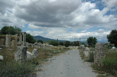 |
|
Type:
|
Cemetery |
|
Altitude:
|
420 m |
|
Region:
|
Aegean |
|
Province:
|
Mugla |
|
District:
|
Yatagan |
|
Village:
|
Turgut |
|
Investigation Method:
|
Excavation |
|
Period:
|
Roman Hellenistic |
|
|
|
 |
|
| Location: It is located; 10 km northwest of Yatagan district; 1 km away from Turgut; 15 km northwest of the Yatagan District of the Mugla Province. It is 9 km far from the ancient city of Stratonikeia [Tırpan 1996:209]. It is reported that it was formerly known as Leyne in the archaeological literature until 1979 [Boysal 1979:389]. |
| Geography and Environment: It is located on a fertile land in the Valley of the Cine Brook [Boysal 1979:389]. |
| History: It has been presumed that the former name of Lagina; which is connected to Stratonikeia by a sacred way; was Hieracome [Bean 1976:477]. According to the information from the inscriptions found at the Köklük Mevkii to the northwest of the Hecate Temple in Lagina; the city named Coranza was situated at Lagina. The researcher also suggests that an inscription belonging to the Coarendans dating from 323 BC actually came from Lagina. [Sahin 1975:178]. The actual name of the city was presumably Coarenda [Sahin 1975:179]. Both inscriptions contain some Carian names. |
| Research and Excavation: In addition to the researchs by Newton in the second half of 19th century and by Hamdi Bey and Chamonard at the end of the 19th century; surveys were conducted by Laumonier in 1940s. Excavations conducted by Y. Boysal in between 1967 and 1970 were followed by excavations led by A. Tirpan in between 1993 and 2011. Excavations at Lagina started again in 2017 under the directory of B. Sögüt. Turgut/ Lagina is listed as an officially registered archaeological site by the Ministry of Culture and Tourism. |
| Stratigraphy: |
| Small Finds: |
| Remains: Temple/Sanctuary: Remains of propylon; stoa; altar and temple were found in the Hecate Sanctuary of Lagina; which is thought to have been under the administration of Stratonikeia. The temenos inclines from west to east [Tirpan 1996:210]. Propylon: It lies to the southwest of the temenos [Tirpan 1996:211]. A Doric stoa is situated to the north of the Propylon [Tirpan 1999a:239]. The Propylon consists of a prostyle structure including Ionic columns in the apsis to the west; and a tripylon in templum in antis plan to the east. It was found out that the tripylon was covered with a semi-sphere in the front and a barrel roof in the back [Tirpan 1998b:178; 1997:313]. There is a crepidoma in front of the west entrance; and the structure is connected to a street. The stairs were probably added later [Tirpan 1998b:178]. It was presumed that this was the sacred way between Lagina and Stratonikeia. The same road continues to east after tripylon; and then reaches the altar in front of the temple [Tirpan 1997:313]. It was observed that the construction technique of the substructure of the propylon is similar to the technique applied in the construction of the wall separating the stoa from the propylon. The wall enclosing the Sanctuary (peribolos) intersects with the propylon together with the stoa in the northern section. But it was found out during excavations that the same was not valid for the southern section of the propylon [Tirpan 1998b:178]. The sounding which was carried out to outline the substructural construction system of the propylon yielded three coins; a glass ornament; and a bone bead [Tirpan 2001:303]. The Ionic capitals of the propylon and a couple of Attic-Ionic based columns are dated to the end of the 2nd century BC [Tirpan 1996:216]. The stairway to the east of the propylon consists of ten steps [Tirpan 1998b:179]. Re-used material was used for the construction of the stairway's substructure. In front of the stairs; there is a gorgeous podium on which some statues stand; constructed as to cover the side wall of the stoa which combines with the propylon. The podium was situated on the pavement blocks of the road leading to the altar and on the stairs of the propylon. Therefore; it is assumed that the propylon and the statue are earlier than the podium of the statues [Tirpan 1998b:179]. The podium was restituted based on the architectural and sculptural finds [Tirpan 1999a:239]. There are honorary inscriptions about Menecles and Epainetos; adopted sons of Leon's son Antipatros in Greek on two of the orthostat blocks that constitute the podium. The foot steps of the bronze statues on those blocks; as well as the pouring channels for dubel holes indicate that two bronze statues were erected for the two brothers. Based on the inscriptions; it was found out they were erected c. 50 BC [Tirpan 1999a:239-240]. The deposit between the stoa and the statue's podium yielded an unguentarium from the 1st century BC. This is an indication of the latest date for the propylon [Tirpan 1998b:179]. The altar is accessible through the paved road at the end of the stairs [Tirpan 1998b:179]. The large pavement; consisting of the large marble blocks between the gate and the altar to the east of the gate is flanked by orthostatic walls. The pavement was connected to the altar via stairs [Tirpan 1996:211-212]. The excavations on this road revealed an architrave dedicated to Helios and Rhodes and a small marble block; which is presumably a votive stone. The architrave may have been belonged to a naiskos dedicated to Rhodes and Helios. The inscription "Kanebos" and the relief of labrys on the marble block show that the Carian god; Kanebos was also worshipped within the same temenos [Tirpan 1999a:240]. During the excavations of 2002 the 4 m high section on the west of the propylon which is constantly filled due to erosions; was cleaned. Friese and geison-sima blocks of the upper structure were revealed on top of the semi-circular steps after the trench was enlarged towards the west direction. The semi-circular entrance was completely revealed. A large section of the sacred road was also revealed which is in the direction of the ancient city of Stratonikeia and which was paved with black stones called "mol Mehmet" stone by the locals [Tirpan-Sögüt 2004:87]. Excavation activities are carried out in 2009 for determining how long the bossaged wall which limits the North of Propylon extends Southeast. Architecture blocks of Propylon appeared after removal of approximately 3 m tall embankment which is on the upper layer. After removing these blocks, a rigid layer is encountered containing pieces of ceramics, roof tiles, and glass. The clay masses in this layer are straw and grit tempered. The base is 0.57 m thick and continues until basement. A floor is unearthed at the level of the third step of the stairs surrounding the apsised entrance of Propylon. The floor is paved with local stones called "molmemet stone" among the local people. Some parts of this floor have been seen in the Southwest during the previous years and now it is understood that it is curling down under the cross-section. The stones which make up the floor cover are thin, sculptured like a plate, flat, and have multiple margins. The second floor base that is in the Southwest of Propylon also curls down under the cross-section. Non-sculptured stones on the flooring here are paved as a block which is different from others. The spaces between the blocks are filled with smaller stones. These floors constitute the passage to Propylon. During the studies carried out in the Northwest of Propylon a baked weight made of earth ware, a bronze earing, three bronze buttons, an iron knife and 38 bronze coins are found. All coins are from 4th Century AC [Tırpan-Gider 2011: 375-376]. During the 2011 studies, the earth fill with a height of 5 m was excavated and the stone paved wall was reached. It was discovered that the bossaged wall extends towards the northwest. This wall built with quadrangle blocks in isodomic masonry. The section facing to the propylon consists of six rows including the foundation. Three rows of the section continuing towards the northwest are preserved. There are differences between the section facing to the propylon and the section facing to the stone paved road in terms of craftsmanship. The section facing to the propylon was constructed by bossage, while the section extending towards the northwest was roughly dressed. As a result of the studies, 7 m of the wall extending in NW-SE was exposed and it continues towards the northwest into the profile. At the end of the third step of the stairs surrounding the apsised entrance of the propylon, the continuation of the floor paved with local stones called molmemet stones by local people was unearthed. It was observed that this road continues archly towards the northwest and ends with stairs. The stones in various sizes that form the paved floor were cut as thin slabs and they are polygonal shaped with straight surfaces. 8 stairs were exposed at the north edge of the stone paved road. Each stairs comprise of 3 separate blocks that were aligned side by side. During the studies carried out on the road and the vicinity of the wall that borders the road, 13 bronze coins were found and all of the coins are dated to 4th century AD. This indicates that this area was intensively used until the earthquake in 365 AD. like the most parts of the sanctuary. The area in which South Stoa is located and the area in which the doorjambs with inscription were exposed started to be excavated. A large entrance was discovered in this area. There are stairs on the west and east of the entrance. No stairs were found in the area in which the façade of the propylon is located. There are 5 steps on the west side while the east side has 7 steps due to the elevation difference. It has 3 columns on the front and it is in prostylos plan. Based on the architectural elements recovered, it was determined that it was built in Doric order. The façade of the structure collapsed towards the south because of the earthquake. It is in compliance with the wall plugs on the stylobate blocks and the wall plugs located on the lower drums of the columns and therefore the lower drums are directly sat on the stylobates and they are non-grooved. During the studies carried out in South Propylon, 26 coins, 11 weights and spindle whorls, 1 marble statue fragment, 1 bronze statuette, 2 ring stones, 1 bronze nail and pin was found [Tirpan et al. 2013:66-68]. Altar: It lies to the east of the propylon; south of the Hecate Temple. It is in the northeast - southwest direction. Its nortwest entrance shows congruence with the Hecate temple; however it is uncertain if the temple and the altar stand on the same axis. The altar with a two staged stylobate was surrounded by a columned parapet. Presence of dubel holes on the stylobate blocks at the second stage suggested that there used to be another row of columns between the altar wall and the parapet. The exterior colonnade is in Corinthian order; while the interior one is in Ionic order. A toichobate in a well-dressed profile; an orthostat row over it; and an orthostat crown decorated with anthemion on the top were found among others. It is presumed that there were blocks bearing reliefs of lotus flowers on the orthostat crown. Fragments of statues and reliefs were found near the altar. A double faced bull protome was unearthed during illicit diggings [Tirpan 1999a:240-241]. The road between the altar and the temple is paved with re-used marble blocks. Two of these re-used blocks have inscriptions from the Hellenistic Period. It is likely that the partially unearthed road is as wide as the temple. There are collapses on the road due to destructions from earthquake or floodings [Tirpan 2002:346; Tirpan 2001:304]. The Temple: The Corinthian order temple has a pseudo-dipteral plan; with 8 x 11 columns. The main façade faces east [Bean 2000:90]. It consists of a pronaos and a naos. Two Ionic columns were found between the anta walls. A block found to the north of the naos; which was paved except for the center; may have been a fragment of the pedestal for the cult statue [Tirpan 2001:299-301]. The absence of any pavement blocks in the center of the naos can be explained with unfinished construction. Collapses were observed on the crepidoma and stylobate of the temple during the excavations and analyses. It was found that the pavement blocks of the naos were bounded by the orthostat blocks [Tirpan 2002:343; 345]. On a frieze block of a corner belonging to the southern façade of the temple; figures of men preparing for a war; a woman; a man with beard with a pathetic face looking like Oceanus or the God of River; Artemis with nine women on both sides are observed [Tirpan 2002:345-346]. The earliest of the coins uncovered in the naos belongs to Alexandros III (336-323 BC); while the others are dated to the Hellenistic and Roman Periods [Tirpan 2001:301]. The Corinthian columns; reported to be found at Hecateion are similar to the ones used in the bouleterion of Miletus; and gymnasium of Stratonikeia. It is suggested that one of the two Corinthian capitals is dated before 100 BC; and the other to a little later date[Boysal 1994:322-323]. As a result of the analyses on the pollens collected from the naos; it was concluded that the Hecate temple might have been used as a cereal store during the war. The grape pollens found suggest that wine was also stored in the temple and even it might have been spilled onto the floor as votive. Furthermore; based on the other samples; type of the vegetation in the vicinity of the temple is known [Tirpan 2001:301-303]. The building blocks which were collapsed from northeast towards the southwest direction during an earthquake were found during the researches performed in the southwest of the altar in 2002. The upper structural elements of the temple were revealed in the same section and the iron concrete inserts; fragments of lead and a bronze insert with the piece of lead around it which did not have a very common utilization were revealed. An axle clout which gives an idea on the ancient restoration work was found above the line of threads duıring the researches [Tirpan-Sögüt 2004:89-90]. A comprehensive research was done inside the temple of Hekate in 2006 ; a restitution offer was prepared based on the building blocks that were revealed. The relation of the temple which was built in Corinthian order was researched in comparison with the buildings that were previously built in order to identify its status within the Hellenistic architecture. The model of Vitruvius was accepted as a basis for the starting point. The measurement tables for each building element were constituted within the limits of this research starting from the lower building; and all the sample building elements were drawn. It was found that the number 6 which was known as the perfect number by the mathematicians of the ancient period was used as a module; and the multiples of the number of 6 was utilized to determine the measurements of the building. The temple demonstrates novelties that are only specific to itself in terms of the proportions that were applied from the euthynteria level up to the upper level building elements. The proportion of the Euthynteria to the stylobat is the only example known in Anatolia with 8x11 columns. The proportions of the Corintihian order building elements were determined taking into consideration the lower diameter of the columns. It was found that the column height was increased compared to the structures of the 3rd century BC; the proportion of the kickplate width to the pedestal height was decreased. When the Hellenistic period buildings built before; and the Roman period buildings that were built after are considered the Temple of Hekate constitutes an example to the transition period architecture. Therefore the mathematical proportions identified inside the temple may be valid for the Late Hellenistic period Corinthian order as well [Tirpan-Sögüt (Büyüközer; A.) 2008:388-390]. The architrave blocks were also researched and categorized on ornamentation basis during the find database studies of the temple in 2006. 96 architrave blocks were found during the researches performed; 72 of those were complete; 24 were fragments close to or smaller than half. The Ionic kymation ornamentations on the architrave crown profiles consist of 5 types. The anthemion ornamentations were also categorized under 5 main groups. The presence of differentiation of the workmanship and the differences deriving from different periods were found on the decorations on the blocks. These tell us that the architrave decorations were made by different persons and it took a long time to complete them. This process probably lasted between the end of the 2nd century BC; until Augustus period [Tirpan-Sögüt (Aslan; H.) 2008:390-391]. Stoa: It is located to the northwest of the propylon; connected with it through a gate. It is suggested that stoa was planned along with the propylon based on its width and floor characteristics [Tirpan 1996:216]. Presumably the pressed sulfate colored soil layer mixed with marble flakes constituted the floor of the stoa [Tirpan 1996:213]. The southern wall was built in isodomic masonry. It is compared to the Classic and Hellenistic walls in Cnidus; Euromos; Priene and Ephesus. A statue podium was added in front of it [Tirpan 1999a:239]. As a result of the studies for preparing a finds database in 2005 it was found that out of the stoas that surround the Lagina Hekate sacred area the Western Stoa was built in an I shaped; single naved; single storey plan; the Northern; Eastern; and Southern Stoas were built in a U shaped; single naved; single storey plan. There is a lower structure containing eleven steps in the front façade of the Western Stoa made for the rituals organized inside the sacred area and three steps on each of the other sides. Doric order was preferred on all façades of the Stoa. The Ionic impact made popular during the Hellenistic period by the architects from Pergamon can be observed in all the Doric building elements [Tirpan-Sögüt (Gider; Z.) 2007:593]. Excavations were performed mainly in the Western Stoa and in the Northern Stoa in 2006 [Tirpan-Sögüt (Sezgin; T.) 2008:392]. During the researches in 2007 it was found that the west stoa had a single nave, with rooms behind it, and 11 rows of seatings in step order in the front. It was identified as Doric order "I" planned and was constructed under the impact of Pergamum. During researches on the section where west stoa meets the north stoa the blocks that composed the peristasis in Doric order were found the way they collapsed. It was found that the nave section of the north stoa that is accessed using two steps consisted of pressed soil basis. Unlike the west stoa Toskania type of pedestals were used underneath columns in the Doric order façade's arrangement. Similar examples were previously identified at Kos, Priene and Miletos where the serration line was worked on geisonsima blocks. The marble stairs which provide access between west stoa and north stoa was made for descending from the nave section with covered top directly towards north stoa's nave section. During the research performed on the nave section of the north stoa, considering the wall made of reused blocks that cross the peribolos which composes the rear wall of the stoa in right-angle and the wall made of reused material built over peristasis blocks, this was constructed as a room. A water distribution system and two pipelines related with that were found between the back entrance of the stoa and the wall that meets the nave in a right-angle. One of the pipelines connects with the round planned pond and the other one with a line which is currently not identifiable. A mint that was found on the same level with both of the pipelines and was dated to Licianus I period suggests that the system belongs to the first quarter of the 4th century BC. The blocks of the marble pond which was built adjacent to the north stoa were brought from another spot and reused. A crescent moon shaped excedra was unearthed in front of the stylobat blocks in the north stoa. Considering its location and position it is assumed that statues were displayed at that spot. The excedra was probably built latest during Augustus Period construction works along with the north stoa. One of the most important discoveries in the north stoa is that it bears marks caused by the enormous earthquake that took place in 365 AC. On one side this earthquake caused the disintegration of the building elements and collapse of the altar, it had a contradicting impact on the north stoa and caused the stylobat blocks to break towards the top. During the researches performed on the northeast side of the north stoa it was observed that the north stoa meets the east stoa in a right angle, two stoas intersect and were designed in coordination [Tirpan-Söğüt (T. Sezgin) 2009:245-248]. Activities for levelling down have started in 2009 after the surface is cleaned up on a 10 by 10 m field in West Stoa. The architectural blocks unearthed in the first layer. Entire seat rows are unearthed with the on-going activities of levelling down after removing the architecture blocks. The strength and effect of the earthquakes occurred in the sacred land can be observed vividly from the seat rows of West Stoa. A bronze ring, a piece of a chain, an iron knife blade, a brazier foot made of baked earth ware, a woman's head made of terracotta, and 5 bronze coins are found around the seat rows. One of the coins is from 4th - 3rd Century BC, one is from 11th Century AC and the rest are from 4th Century AC. The entrances are cleaned up and the threshold stones are unearthed beginning from the Northwest corner of West Stoa. A baked weight made of earth ware, an iron knife blade, hand axe, and a bronze coin are found during the activities carried out on the rear wall of West Stoa [Tırpan-Gider 2011: 376]. In North Stoa in 2009 the initial focus of activities was the steps from West to North Stoa. During the previous years the steps are located in the South of the passage to the steps in the North. Two baked weights made of earth ware, a baked lid made of earth ware, and one oil lamp is found during the excavations carried out on the passage. And intense amount of ceramic and roof tile pieces are unearthed. During the previous years the Northwest corner of North slope is opened and this year the activities are extended 55 m towards East. The North Stoa is single planned, single naved and single floored. The depth of the nave is 6.80 m. Its rear wall is partly preserved and regularly sculptured marble block rows -of which only a single row is preserved- with orthostatic blocks in the centre exists. The height of the orthostatic blocks is 0.89 m, and their depths are between 0.275 and 0.365 m. The rear faces of blocks are not processed and a wall made of quarry stones is seen at the back. This wall is constructed to support the rear wall of Stoa and its width is up to 1 m. Marble blocks which are 0.28 m high and 0.90 m deep, rectangular, and which are flattened in the front are placed on top of the orthostatic blocks. A two-step infrastructure exists in the front face of North Stoa. The stylobate blocks constitute the third step. During the excavation activities in North Stoa, the architectural blocks are documented where they have collapsed during the earthquake. Dor architrave with double fascia is used on the front of the upper side decoration of North Stoa which is popularized by architects from Pergamon as a reflection of Ionic influence. A large entrance is detected which is opened in the rear wall of North Stoa. This entrance connects Koranza antique city and the sacred land therefore it is named as "Koranza Gate". The gate is 2.20 m wide, 1.47 m deep and it is located in the centre of North Stoa. The threshold of the entrance and the basis of jambs are found in situ and the jamb blocks are unearthed in the entrance in a collapsed position. An area of 4 meters in the North of the entrance is excavated and the orthostatic blocks which limit both sides of the entrance are unearthed here. Intense amount of pieces of roof tiles are unearthed from the nave of Stoa deeper than the late period Building A in the West. Some tile pieces with the word "EKATH·" (Hekathe's) are found while cleaning up the roof tiles in the East of Koranza Entrance [Tırpan-Gider 2011: 377-378]. Among the most important data obtained from the 2009 excavations carried out in North Stoa are the monumental sculpture bases. Another important structure is the semi-circular Exedra which is located in the West edge of the field where the monumental sculpture bases are. The structure's height is 4.75 m, radius is 2.50 m and it is preserved at the foundation level. The 2007 excavation activities continued this year on the corner where North and East Stoa are connected. This field is very close to surface where Stoa steps and stylobate blocks are completely destructed, and only the level of euthynteria is preserved in situ. It is observed that the column drum of Stoa and two triglyph metope blocks extend under euthynteria level and the excavation studies continued in this part. With the excavation activities held in 2009 it is determined that the rear wall of North Stoa is built above the Early Period peribolos wall. This wall is exposed in the outer side of Northeast corner of the sacred area and extends West. Only two rows of stones of it were preserved below the rear wall. This wall from the 4th Century BC suggests that the sacred area was used as peribolos wall before construction of stoas [Tırpan-Gider 2011: 381]. The nave section was completely exposed during the 2010 studies in North Stoa. The North Stoa is "I" planned, single naved and single floored. The depth of the nave is 6.80 m. A two-step infrastructure exists in the front face of North Stoa. The stylobate blocks constitute the third step. It has been suggested that the front face built in Doric order had Toscana style base. But this base couldn't be found. There are some differences between the west and the east sections of the stoa in terms of craftsmanship. During the studies in the nave section, it has been observed that the fragmented roof tiles were continued. There are some fragments of opaion tiles among the debris consisted of stroters and kalypters. A kalpyter which can be completed was also recovered. The architectural remains belonging to monumental sculpture bases and the architectural blocks with and without inscription belonging to these sculpture bases were found. The sculpture bases were found independent of each other on two different podia. These podia were situated on crepis. The podia are arranged in two rows and one of them is 7.60 m long. There 3 sculpture bases on this podium. During the North Stoa excavations, 59 artefacts were recovered. Among these artefacts, there are 3 baked clay weights, 3 bronze objects, 5 iron objects, 1 silver nail, a fragment of marble votive stele, 1 baked clay lamp, 44 coins and 1 piece of terracotta [Tirpan-Büyüközer 2012:434-440]. 3 entrances which were thought to be stores were exposed during the studies performed on the northwest corner of the west stoa in previous years. These entrances located on the west wall which border the backside of the stoa were excavated this year. The one located on the northwest corner was called "Store 1" and the other one on its south was called "Store 2". Store 1 measures 7.80x5.20 m and it is rectangular planned. The entrance with a width of 1.98 m faces to the nave section of the west stoa. The north and the west walls of the store are 0.90 m thick. The partition wall between Store 1 and Store 2 is 1 m thick. Store 2 measures 5.20x5.20 m and it is square planned. The width of its entrance is the same with the entrance of Store 1. The entrance faces to the nave section of the west stoa as well. Expect being square planned; Store 2 is the same with Store 1 in terms of architectural features [Tirpan-Büyüközer 2012:441]. During the 2011 studies, the existence of the bossaged wall dated to the mid 2nd century BC. was discovered and it was determined that it was used as the south border of West Stoa in the later period. There was a single block belongnign to the arrangement where the coloumns were sat in this area. Similar blocks were used as spolia in the late period arrangements exposed during the excavation conducted in the south and north of West Stoa and the arrangement in which the coloumns were located in West Stoa was clearly unearthed. On the contrary the other stoai, pedestal was not used and the columns were directly placed on the stylobate. The other thing that differs West Stoa from the other stoai in the sanctuary is the usage of cornice. West Stoa is in the group consists of "I" shaped stoai with a single storey and nave. The direction of the Temple and Altar was taken as a basis for the direction of West Stoa [Tirpan et al. 2013:60-61]. It was discovered that the orthostat blocks found during the studies carried out in West Stoa continue towards the west into the profile. Based on the idea that these blocks could belong to the stores, the area was extended up to 2 m to the west. As a result of the leveling down activities, at a depth of 0.50 cm from the surface, wall blocks extending in the south-north direction were unearthed. The orthostat block found under the wall blocks shows that these blocks are in situ. So, a structure the south, north and west borders of which are clear, was exposed. It was seen that the dimensions of the wall and orthostat blocks match up with the dimensions of the wall blocks of Store 1 and Store 2. In Store 5, 4 bronze coins and 1 silver coin dated to Roman period, 2 bronze coins dated to Hellenistic and Byzantine periods, a bronze bell and bronze earrings, terracotta figurine head, marble statue fragment, iron razor and 2 knives were found. During the studies carried out on the east of the pumice stones, 3 coins dated to Roman Period were recovered. Also 2 coins dated to Roman Period were found on the surface. Corinthian and Lakonian stroters and kalypter sherds, diagnostic sherds such as rim and lugs and body sherds, glass fragments, iron slag, bronze object and nails were found as well. During the studies carried out inside Store 6, an "L" shaped orthostat block was found at the southwest corner of the wall of the store. To the north, the orthostat blocks that form the back wall of the store were unearthed. It was discovered that neatly cut pumice stone blocks were placed over these blocks. It is suggested that the pumice blocks used in Store 6 were placed in the later period. Orthostat blocks belonging to the partition wall were recovered on the north of the wall. Store 6 is in squarish plan and measures 5.75x5.50 m. A great number of architectural blocks that probably collapsed towards the west of the back wall of the store due to the earthquake were exposed. 4 of these architectural blocks are triglyph metope blocks, 4 of them are architrave blocks and 9 of them are geison-sima blocks. These blocks show the existence of Doric superstructure, the façades of architectural blocks of which faces to the west, was located on top of the back wall of the store. The front faces of the architrave blocks have two fasciae. There are 6 guttae on the regulae and at the corners there are 3 guttae. The triglyph metope blocks are similar to the ones in stoai except a few differences in size. The mutulus slabs of the geison-sima blocks were left plain and there are dentils which are not normally seen in Doric order. 11 bronze coins and 1 silver coin were found in Store 6 and its vicinity. Also, 1 ampulla, 1 weight and 1 spindle whorl were recovered. 8 of the coins are dated to 4th century AD. [Tirpan et al. (M. Ekici) 2013:62-65]. Pond: It is located approximately 150 m southwest of the propylon. It is fed by a spring enclosed by re-used marble blocks; 50 m to the south. A cylindrical altar was found during the excavations dating to the Late Hellenistic Period; with reliefs of Moses [Tirpan 1996:214]. The pond walls of 9.55-10.4 m with an oval plan were built of coarse masonry. The surface facing the pond was plastered with a limestone mortar. The walls have been preserved at a height of 1 m at some places; and of 2 m at others [Tirpan 1996:214]. Studies on the floor of the pond showed that the floor originally consisted of marble blocks overlaying a sanded layer of clay; and that in a following phase; it was covered with fist size stones by deepening the basin of the pond [Tirpan 1996:214-215]. To the southwest of the pond; a water channel that brings the water to the pond was found. It was found out that the channel connects to the spring in the south. Restoration activities were carried out in the pond [Tirpan 1996:215]. It is unlikely to date the pond; referred in the Lagina inscriptions [Tirpan 1996:216]. In 2007 a pool structure as well as other watering elements from 4th Century BC was documented in a distance from the Northeast corner of North Stoa. Remains of a wall which implies the existence of a building in this field is excavated in 2009. The North of this building is limited by the rear wall of the Stoa, while its East and South walls are made of various sizes quarry stones. The Southern wall of the building is constructed by filling the space between two columns with quarry stones. When the building was constructed together with its Toscana Style base, the column drum in the Southeast corner of this wall was in situ; since the corner which joins the South wall and the East wall is entirely made up of this column [Tırpan-Gider 2011: 382]. Necropolis/Graves: Out of the three necropolises that are 1-2 km far from the city; the one to the east at the Yarbasi Mevki is dated to the First Bronze Age. The necropolis lying to the south of the city at the Bozukbag Mevkii is from the Late Geometrical Period; and the one at the Emirler Mevkii is from the Classical Period [Boysal 1979:389-390]. It was found that the average life expectancy among adults was 36 years during the paleoanthropological analysis of the skelettons revealed inside two separate burials of Lagina Sacred Place in 2000 and 2001. The women's average height was154-159 cm; and the men's average height was between162-170 cm . Various finds were traced during pathological researches in the body pathology which were reflected on the bones [Güleç et al. 2006:21-28]. An excavation was performed in 2002 in the area called Yayalar Mevkii; 10 m south of the sarcophagus revealed in 2001; inside one of the graves placed on the terraced field. The grave has an entrance in the north; and it was built in north-south direction by carving. As a result of the excavations it was found that the grave had a front room and a second room behind the entrance. Klines were found at 1.65 m depth. A corroded silver and other bronze piasters; golden diadem fragments a terra cotta lantern; sherds; iron nails and bones were revealed during the researches. The ordinarily placed human bones inside the promenade section at 2 m depth; belong o a human; and these were either thrown or fallen there based on the position they were found. The reason that corroded silver and other bronze piasters; golden diadem fragments a terra cotta lantern; sherds; were found at this location as well; and the reason for the scattered bones is probably not due to reuse of the burial; but the destruction by the illicit diggers. The fact that the amount of the bones out of the Klines were too many; proves that there were more than one burial. As a result of the evaluation of the finds the earliest find inside the grave is from the 4th century BC. The other finds belong to the Hellenistic and Roman Periods [Tirpan-Sögüt 2004:92]. Bones of two children and eight adults were found inside the grave that was opened in 2002. The bones of goats; sheeps; cats; dogs and birds were also found. The fact that there were more skelettons than the number of the kline inside the grave suggest that the grave was used multiple times in different periods [Tirpan-Sögüt (Satar; Z.) 2004:94]. |
| Interpretation and Dating: |