|
©The Archaeological Settlements of Turkey - TAY Project
|
|
|
|
|
|
Idyma |
|
|
For site maps and drawings please click on the picture... 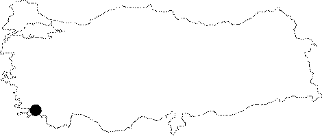 |
For photographs please click on the photo...  |
|
Type:
|
City |
|
Altitude:
|
m |
|
Region:
|
Aegean |
|
Province:
|
Mugla |
|
District:
|
Ula |
|
Village:
|
Kozlukuyu |
|
Investigation Method:
|
Survey |
|
Period:
|
Classical Hellenistic Roman |
|
|
|
 |
|
| Location: It is located within the borders of the Kozlukuyu Village to the south of the Mugla Province [Bean-Cook 1957:68]. |
| Geography and Environment: As there is no large river spilling into the Gulf of Gökova (Keramos); there is no much alluvial deposits. In the Ancient Period; the ships were anchoring somewhere at the northeastern corner of the gulf; however today they use the port; 1 km to the west. With a mountaineous northern shore; a 7-8 km long and 3 km wide fertile plain stretches inland behind this gulf. The sources between the sea and Kozulukuyu on the northern edge of this plain feed the Kadin River. The plain ends up with a range of lower hills on the east. Idyma is located 300 m above the Kozlu Kuyu Village [Bean-Cook 1957:68-69; 72]. |
| History: It is known that it was a member of the Delian League until 440 BC; and ruled by the dynast Paktyes. She struck silver drachmas with the head of Pan and a fig leaf. Around 200 BC the city fell to Rhodes. Although she gained her independence after a while; the city was recovered by the Rhodian general Nikagoras [Bean 1976:405]. |
| Research and Excavation: It was visited by Cousin and Diehl during the 19th century; and a survey was carried out in 1921 by Guidi; in 1934 by Robert; and in 1954 by Bean and Cook. It takes place in the registered archaeological sites list prepared by Ministry of Culture and Tourism. |
| Stratigraphy: |
| Small Finds: |
| Remains: The borders of Idyma reach out the shore. However; the city was located on the spur of a mountain; 3-4 km inland during the Classical and Hellenistic Periods. The acropolis located c. 300 m above the modern village (Kozlu Kuyu) can be reached through a main road; which passes above it [Bean-Cook 1957:68]. City wall: The fortifications are approximately 200 m long. Although some well-cut stones can be observed at several points; it was mainly erected by raw stones; with an approximate thickness of 1.4 m. Remains of a small fortress are traceable. There is a tower piercing the defense wall to the east. To the further east; traces of a 1.95 m thick outer wall are observable. It randomly extends to the southwest of the acropolis. This area is believed to have been used as a residence area. The survey yielded black glazed potsherds from the 4th century BC; potsherds and fragments of tiles from the Hellenistic Period; fragments of red ware resembling the sigillata of the Late Hellenistic Period; however no finds from the Roman Period were uncovered. In Kozlu Kuyu; one coin of Cassander; two coins of Ptolemaios and a few Hellenistic Rhodes coins were found. It is believed that the fortress was inhabited by the ruler and members of the dynast. The buildings are presumably dated to 400 BC [Bean 1976:405; Bean-Cook 1957:68-70]. Cistern: To the west of the remains of a small fortress; there lies a cistern; which measures 10x6 m. Necropolis/Graves: Graves with temple façades lie on the roadside to the west of Kozlukuyu; below the city and at the skirt of the mountain. They are mainly in Ionic order [Bean 1976:405]. There are also some rock graves on the slope of the steep hill to the northeast of the Kozlu Kuyu Village. A well was found in one of the floor of the burial chamber of these graves. In Ionic order; this grave was dated to the 4th or 3rd century BC by Guidi; and to the 4th century at latest by Robert. A similar type of grave was found in Camköy; near Yenice which is located in a plateau behind Idyma. With the help of the graves in Lycia; Telmessos; caunos ve Kibyratis; the Ionic graves in Idyma are dated to the beginning of the 4th century. Based on the coins from the same period and presence of these graves; it can be concluded that Idyma was ruled by a dynasty [Bean-Cook 1957:71]. Miscellaneous: There are remains from the Roman Imperial period and Byzantine Period in the ancient port to the northeast of the Gulf of Gökova. Some architectural remains; probably of a watching tower; were found between the modern and ancient ports. Also found are some architectural remains with a polygonal masonry on the western section of a hill; northern edge of the plain between the ancient port and Kozlu Kuyu. Near this place; presence of a paved road leading to Marmaris and two bridges was reported [Bean-Cook 1957:72]. |
| Interpretation and Dating: |