|
©The Archaeological Settlements of Turkey - TAY Project
|
|
|
|
|
|
Alabanda |
|
|
For site maps and drawings please click on the picture... 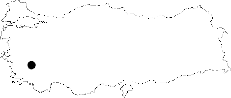 |
For photographs please click on the photo... 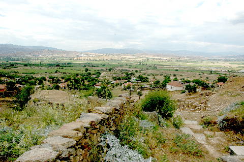 |
|
Type:
|
City |
|
Altitude:
|
m |
|
Region:
|
Aegean |
|
Province:
|
Aydin |
|
District:
|
Çine |
|
Village:
|
Doganyurt |
|
Investigation Method:
|
Excavation |
|
Period:
|
Hellenistic Roman Classical |
|
|
|
 |
|
| Location: It is located where the Doganyurt Village; formerly Araphisar; is situated; 7 km west of the Çine District of the Aydin Province [Tirpan 1990a:171]. |
| Geography and Environment: Strabo records that Alabanda was situated in the saddle of two elevations; resembling a donkey with panniers [Strabo 14; 2; 26]. The city was founded at the skirt of the hills extending to a plain. |
| History: In Carian language; Ala means horse; and Banda means victory. The mythological king of the Caria; Car; named his son Alabanda; where; then; it survived to our days as the name of the city. However; Cicero tells in his book "The Gods' World"; that the city was named after Alabandos; the god of Caria. According to Herodotus; the tyrant of Alabanda; Aridolis was also involved in the army of Xerxes during the war in 480 BC [Herodotus 7; 195]. It is known that Alabanda joined the Carian Cities in the 3rd century BC. The city initiated to strike coins in the 3rd century BC; with depictions of Pegasos figures. Coin striking also continued during the Roman Imperial Period. Alabanda received the name of Antiochia of the Chrysaorians after it was captured by Antiochus III. The first coins under this name were struck in the early 2nd century BC [Tirpan 1990a:171; krs. Yener 2001:6]. Occupied by Macedonians during the reign of Philip V in 205 BC; and then by Seleucids after the Battle of Magnesia in 190 BC; followed by dominion of Rhodes for a while; the city finally regained its independence by supporting Mylasa [Yener 2001:6] during the war between Mylasa and Rhodes in 167 BC; and resumed its name Alabanda. From 133 BC; it became a part of the Asian District under Roman administration upon bequeathal of the King of Pergamon. Cicero tells that Alabanda was in debt to a Roman banker; Cluvius in 51 BC. The city was punished by Labienus; who left a garrison in Alabanda; by making an agreement with the Parthians when they rebelled against him. In 48 BC; when Ephesus became the capital of the Province; Alabanda became the capital of the district covering Miletus; Priene; Tralleis and Nysa. Strabo tells that Alabanda was rich and prosperous during the Roman Imperial Period [Strabo 14; 2; 26]. According to Livius; Alabanda sent a gold crown weighing about 23 kg and many presents to Rome in 170 BC [Yener 2001:6]. During Christianity; it became a bishopric subject to Aphrodisias [Tirpan 1990a:171-172; Yener 2001:6]. |
| Research and Excavation: Visited by Pococke between 1736 and 1740; by Fellows in 1840; and by Le Bas between 1824 and 1844; the excavations in the city were initiated by Halil Ethem Bey in 1905-06; revealing the Temple of Apollo Isotimos and the Temple of Artemis Hecate. The Alabanda inscriptions were analyzed by Laumonier; and the coins by Head; while Bean introduced the structures composing the city [Tirpan 1990a:172]. The city walls were explored in detail during the researches carried out by Tirpan. Directorate of Aydin Museum conducted excavations at Alabanda from 1999 to 2006. Following a 5 year interlude, S. Ateslier took over the work in 2011 and led the excavations until 2013. Directorate of Aydin Museum excavated the site in 2015 and 2016. Today, A.Y. Tavukçu is the excavation director at Alabanda. Alabanda is listed as an officially registered archaeological site by the Ministry of Culture and Tourism. It takes place in the registered archaeological sites list prepared by Ministry of Culture and Tourism. |
| Stratigraphy: |
| Small Finds: |
| Remains: City Wall: The total lenght of the city wall of Alabanda; which is composed of the upper town with three summits and the lower town down in the plain is approximately 4.5-5 km. Made of pegmatite; the wall is about 2.9 m thick. It consists of a rubble fill between the two walls. Two types of bonding techniques were observed: first; rectangular and square stone blocks were supported by lintels and constructed by bossage; and second; the exterior surface of the wall which is composed of rectangular blocks again with lintels; was modified. The walls of the upper town frequently have elbows and steps depending on the topography; which is not the case for the walls of the lower town situated on a plateau [Tirpan 1990a:172-173; 176]. The 2012 studies show that the first phase of the city wall surrounding the city belongs to pre-Hellenistic Period and is dated to the mid 4th century BC. The thickness of these walls is 3.20 m. The spaces between gneiss blocks on both sides were filled with rubble and the spaces between these blocks were built with irregular horizontal blocks. City walls were discovered at a distance of about 1 km, on the northern slopes of the ancient city. These walls are too long to be the outer defense system of the main city and they surround large plains. Therefore, these walls are not related to the city walls of Alabanda that was built in 4th century BC. It is suggested that these walls are dated to the 5th century BC based on its masonry technique and crafmanship. Some parts of these walls were built with trapezoid blocks, while some parts were erected with polygonal blocks. They are preserved up to 2 m high and cover an area of about 5 km [Ateslier-Akkurnaz 2014:491-492]. The cleaning studies were carried out on the city walls in 2015. In this area, a few yellow and green glazed Byzantine potsherds (taken for study collection) and dark blue glass bracelet were found. In the arched structure in the south, 3 coins were found [Akkan et al. 2017:315-316]. Towers: The upper city wall is pierced by fourteen towers. Similar to other structures of the city; the towers were constructed by pegmatite. The tower K1 on the eastern wall is the highest one with a dimension of 18x11.85 m. The outer walls reach to a height of 4.2 m while the inner walls are lower depending on the land. Big bossaged blocks; re-used fusts; smoothed rectangular blocks were employed during the construction. The tower walls which have a variety of material and bonding are approximately 1.9-2.1 m wide. The tower K2; which is located on the east like K1 measures 8x6.5 m and it is 1.4 m wide. The tower K4 on the southeastern hill of the city measures 6.8x8.5 m. Four sides of the tower face exterior as it combines with the wall at the corner. The tower K6 on the south measures 6.2x5.3 m; frequently involving lintels among the rectangular and bossaged blocks. Located very close to K6; the tower K7 measures 6.7x7.5 m. It has been highly preserved with a height of 9.05 m. It is similar to K6 in construction technique. The lower part of the tower adjacent to the city wall has been filled with debris up to the inner floor. The entrance to the tower is pierced by a door from the rampart walk on the walls. There is a triangular loophole on the tower walls. The tower K10; which is located on the southwestern part of the city; combining with the city walls with a right angle; measures 11.4x9.2 m. It appears that it had been renovated in the Middle Age. The tower K11 lies on the northern skirt of the hill to the southwest of the city. Combining with the city wall with a right angle like K10; it measures 7.6x2.3 m and it is 1.5 m thick. There is a door on the western wall as well as another one across it opening to the city wall. Tirpan indicates that he couldn't have located the pentagonal tower referred by Akarca [Tirpan 1990a:173-175]. Gates: Among several gates; K1 is located to the east; about 50 m north to the tower K2. The jamb of the gate; which has been poorly preserved; composes of rectangular and modified stone blocks. It has been informed that the road passing through the gate is distinguishable. The gate K II to the west of the city is situated between the towers K9 and K10; being approximately 3 m wide. The gate called K III is on the tower K10. It has been suggested that the gate K IV should have been located where the road combines with the city wally; on the basis of the presence of the ancient road in front of the tower K12 [Tirpan 1990a:175-176]. Furthermore; it was proposed that the city walls take a V-shape in the brook between the two elevations to the south of the city; accompanied with a gate. On the skirts of both hills lie two opposing towers; which are supposedly towers called K4 and K5 in the Tirpan's plan. It seems that there were three building phases depending on the differences on the stone bonding technique used in the city walls; towers and gates; the first phase includes rough-hewed bossaged type of square and rectangular stone blocks randomly supported by lintels; which was common in Caria in the 4th century BC. Thus; it has been claimed that the earliest building phase of the city walls in Alabanda probably dates back to the last quarter of the 4th century BC. During the second phase; fine-hewed rectangular blocks were again supported by lintels. Due to similarity with the analemma wall of the Alabanda theater in terms of bonding technique; it was considered to date; at earliest; before the last quarter of the 2nd century BC. The third phase is at the Middle Age where abundant number of re-used materials were employed and traces of repairs are still prominent [Akarca 1998:169; Tirpan 1990a:176-177]. Agora: It was assumed that the area measuring 72x114 m to the south of the city was probably the agora; based on its distance to the bouleuterion [Akurgal 1995:402]. The 2012 excavations yielded 23 architectural blocks including 10 immense pillars (elephant feet), 2 column drums, and 1 Doric capital. These blocks are dated to 4th century AD [Ateslier-Akkurnaz 2014:491]. Bouleuterion: It lies to the north of agora. Seating rows of the square structure have a semi-circular shape. There are four entrances to the south; and one each to the east and west. The gates on the southern wall have projecting cornices and windows. It resembles the bouleterion in Termossos as the upper part of northern outer walls were decorated with pilasters. It dates back to the Hellenistic Period [Akurgal 1995:401-402]. In 2015, the studies aimed to documentation. Bouleuterion was built with thin brown stones anf the walls are thick. The majority of the structure remained intact. There are inscriptions in Greek indicating masters or workshops on the eastern wall blocks. Although the structure, which has never been excavated before, contains earth-fill, a floor rising towards the back and a curved sitting area were found [Akkan et al. 2017:314-315]. Theater: It was built on the slope of the hill to the northwest of the city. Once probably very large; it has been poorly preserved. The façade faces southwest. Except the seating rows made of marble; local granite and gneiss were used everywhere. The cavea; larger than a semi-circle; appears to have had two diazomata. A passage with two 12 m long and 3 m wide barrel-vaults [Yener 2002:185] leads into the first diazoma. The analemma walls are bossaged [Yener 2001:7]. The excavations in the orchestra revealed some modifications carried out during the Late Roman Period [Yener 2002:180]. Doric columns were used on the scene. It is indicated that the theater of Alabanda is very similar to the theater of Magnesia. Built during the Hellenistic Period; it underwent renovation during the Roman Period [Akurgal 1995:401; Bean 2000:195; Yener 2001:7]. During 2003 the excavation and clean-up work continued in the theatre and the basement level of the orchestra is reached. Considering the simple lime fireplaces and signs of fire, it is understood that the marble seating steps in the first division of cavea are broken greatly and made of limestone in the later periods. The parapet wall made with irregular workmanship on the last seating row in the orchestra line implies the use of theatre during the Roman Period. 3 sculptures are captured in the unearthed Western half of the skene. One of the sculptures is believed to be representing Nike [Yener 2005: 109-110]. The excavation and cleaning work in the theatre continued in 2005 while the ground level is reached in the scene building after the embankment is removed. Pieces of marble reliefs and architecture as well as pieces of some sculptures are captured among the embankment soil. Walls on the scene building are protected up to the ceiling level. Few pieces of ceramics from the Hellenistic Period are captured from the ground level where Roman Period ceramics pieces are relatively intense. Two late period graves are unearthed made of quarry stones on paraskenium in the East of scene building. The graves are opened and cleaned but no findings are captured apart from the skeletons [Yener 2007: 173]. Bath: To the south of agora lie the ruins of a bath [Akurgal 1995:402]. During the 2105 studies, the orchestra was cleaned until the floor level and the floor was revealed. The floor was paved with marble plaques on a tile red colored mortar. However, the floor was damaged and only a few parts of it could be found in situ. In the north of the theater, the studies were also conducted in the area that was publicized in previous years. During the demolishing of the house in the area, spolia blocks belonging to the theater were revealed. A bronze coin, the front face of which depicts an emperor bust who is wearing a radiant crown and the back face depicts an eagle, was found. In the upper storey of the demolished house, two fragments of a marble column base were determinedIn the southwest area, an architectural fragment with dentils and a block having a profile like interlocked niches, and a marble fragment, one face of which bears a Latin inscription in 3 lines and the other face has a groove in the size of a footprint, were revealed [Akkan et al. 2017:311-314]. Stadium: The studies were conducted in the structure that is believed to be the Stadion discovered in 2015. It is in a semi-circle shape and the turning section faces the west. It joins with the city wall in the east [Akkan et al. 2017: 320]. Bath: In 2015, it is found out that the bath is located in the center of the city and it has an arch. Although the plan of the structure is not clear yet, the existence of a large door may indicate that this structure might be a bath-gymnasium complex [Akkan et al. 2017:315]. Cistern: In 2013, the excavations were carried out in the Cistern with Butress. During the studies, 7 pools and baked clay pipes and U shaped gutters belonging to drainage basin and drainage system were found [http://www.ttk.gov.tr/templates/resimler/File/Kazilar/2013/25-2013_Alabanda.pdf, 2.7.2016, 18:12]. In 2015, the excavations began from the north hillock of the structure remains. In the northwest section of the area, a different technique was applied to the original structure and large cut stones were added. It is found out that these additions were made in the late period. During the excavations, the potsherds selected for study collection were found [Akkan et al. 2017:317]. Aqueduct: The remains of a Roman aqueduct can be traced on the Kemerderesi to the immediate south of the city. Temple/Sanctuary: Temple of Artemis: It is situated on a terrace to the west of the theater. In a Doric order; it has 6x11 columns. It consists of a deep pronaos and a naos. Although depiction of Apollo was found on the coins uncovered during the excavations; the fact that the façade faces west and a figurine depicting Artemis Hecate was revealed on the terrace indicates that the temple was dedicated to Artemis [Bean 2000:197-198; Boysal 1994:329]. Temple of Apollo: It has an Ionic pseudo-dipteral version of 8 x 13 columns. As reported by Vitruvius; it was built by Mnesthes; an architect from the Hellenistic Period. A fragment of frieze with a depiction of the Amazon Battle probably belongs to the temple. The building is dated back to the second half of the 2nd century BC [Akurgal 1995:402; Boysal 1994:329-330-Yener 2002:183]. Zeus Chrysaoreus Doric Temple: The Temple was built on an artificial terrace located 200 m northwest of the theatre. The column drums and cella walls of the temple, which were built with local gneiss, were covered with stucco (fine plaster used for coating wall surfaces or moulding into architectural decorations). The temple is in peripteral plan with 6x11 columns and based on its building technique, craftsmanship and finds, it is dated to thr mid 4th century BC. The gneiss blocks located on the stylobate ground encircle the column bases. The walking floor (pteron) between the blocks located under the column bases and cella wall was made out of compressed earth. The fact that stone pavement was only used on the column base indicate that the structure was built in Arhaic tradition [Ateslier-Akkurnaz 2014:488]. In 2015, it is determined that the aqueduct and Ince Kemer Bridge located 19 km south of Marsyas were connected. Although the arches of the bridge are larger, both structures are in similar character [Akkan et al. 2017:319]. Nymphaeum: In 2015, a Nymphaeum consisting of seven crutches and six alcoves was discovered. The upper section of the Nymhaeum was completed with simas. It is stated that water flows from the rightmost niche in winter. This structure has also connections with Ince Kemer (which provided water to the city) originates from Gerga city [Akkan et al. 2017:320]. Temple of Apollo: In 2015, the cleaning studies were carried out. Two coins were found and taken for study collection. The cella, the area between the cella wall and the pteroma, and the naos were cleaned and documented [Akkaya et al. 2017:309-310]. Zeus Chrysaoreus Doric Temple: In 2015, the southwest section of the temple was excavated. Mosaic fragments were found on the northern slope of the temple terrace, 10 m west of the pile of earth in the west of the temple [Akkan et al. 2017:308-309]. Temple of Dionysos: It was determined during the studies carried out in 2015. In the courtyard of the house in the east of the cavea of the theater, 52 Doric column drums were found in the area used as a stable. The original wall remains were found in situ in the north of the courtyard. It is assumed that it could be the temple of Dionysos due to the connections with the theater. In order to excavate the area, the private area where the remains were discovered and the modern house is located has to be publicized [Akkan et al. 2017:320]. Sanctuary: At acropolis; a 80 cm thick altar was established by carving a 1 m wide area in front of a stone which becomes sharper as moved upward at a height of 2.05 m on the slope facing the theater [Diler 1996:319]. Necropolis/Grave: On the road to Alabanda; 3.5 km west of Çine; also found are a grave stele on the wall of one of the houses in Kahramanköy and an inscripted sarcophagus in the Alabanda necropolis. The inscriptions provide information about the profession of the deceased [Bean-Cook 1955:52-53]. In 2012, the studies were carried out in the necropolis surrounding the city. Almost 500 sarcophagi were discovered. The sarcophagi were made out of gneiss. The one with relief found in the eastern necropolis and dated to the Roman Period measures 2.30 in length, 1.50 m in height and 1.10 m in width. Its depth is 0.77 m and the thickness of this sarcophagus ranges from 22 to 24 cm. This sarcophagus is the only example bearing relief that has been discovered so far in the ancient city. The floor of it is thick and it slightly gets narrow through the bottom. Each short side has clamp holes. In the southwest of the city, city walls belonging to 5th century BC and 4 burial chambers dated to the Classical Period in the area between Araphisar Quarter and Dereköy Village in the south of Alabanda. These burial chambers are located at a distance of 800 m from Alabanda city walls. Therefore, they should belong to the necropolis of the city [Ateslier-Akkurnaz 2014:492]. During the 2015 studies, an area called mausoleum (Columbarium) was determined. It is located in the south of the ancient city. It was published as a chapel but it is found out that it is too small for a chapel, and the studies show that it is a mausoleum. The rock-cut grave (only a single door of which could be found) and the sarcophagi carved into the rock prove the existence of a necropolis in the south [Akkan et al. 2017:321]. |
| Interpretation and Dating: |