|
©The Archaeological Settlements of Turkey - TAY Project
|
|
|
|
|
|
Topakhöyük |
|
|
For site maps and drawings please click on the picture...  |
For photographs please click on the photo... 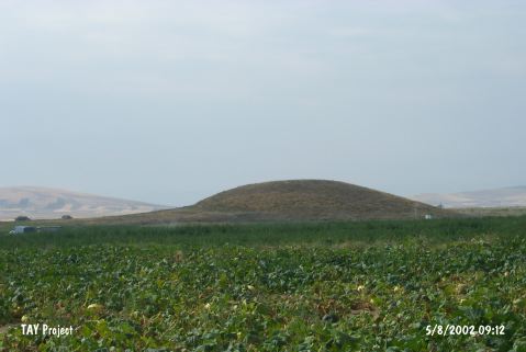 |
|
Type:
|
Mound |
|
Altitude:
|
1130 m |
|
Region:
|
Central Anatolia |
|
Province:
|
Nevsehir |
|
District:
|
Gülsehir |
|
Village:
|
Ovaören |
|
Investigation Method:
|
Excavation |
|
Period:
|
|
|
|
|
 |
|
| It is located west of Nevsehir Province at the city bored to Aksaray Province. It lies 2.7 km southeast of Ozancik Village; 3 km south of Ovaören Village; northeast of Aksaray Province; southwest of Gülsehir District. It is a conic mound. It measures 20 m in height and 50 m in diameter. It was discovered by the Kaman Kalehöyük excavation team under S. Omura in 1996; and included in the EBA settlements. Any samples of the intermediate ware; painting decorated Alisar III ware dating from the last phase of EBA were not found. It was revisited by S.Y. Senyurt in 1997 and indicated as within the territory of Nevsehir Province. Sherds of the Chalcolithic Age; the EB; MB-LB Ages productions were collected from the surface. |
| Location: It is located west o Nevsehir Province at the city border toAksaray Province. It lies 2.7 km southeast of Ozancik Village; 3 km south of Ovaören Village; northeast of Aksaray Province; southwest of Gülsehir District. |
| Geography and Environment: Located 350 m west of Yassihöyük, Topakhöyük and Terrace Settlement cover an area of about 17 hectares [Senyurt et al. 2014:62]. |
| History: |
| Research and Excavation: |
| Stratigraphy: |
| Small Finds: |
| Remains: |
| Interpretation and Dating: |