|
©The Archaeological Settlements of Turkey - TAY Project
|
|
|
|
|
|
Yumuktepe |
|
|
For site maps and drawings please click on the picture...  |
For photographs please click on the photo... 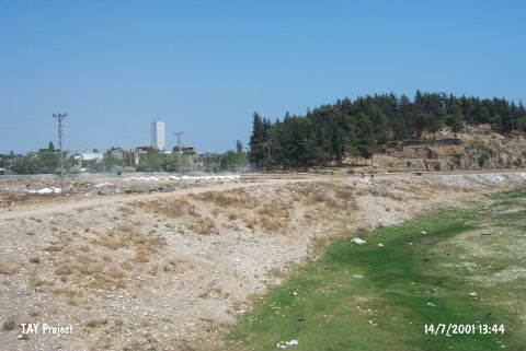 |
|
Type:
|
Mound |
|
Altitude:
|
150 m |
|
Region:
|
Mediterranean |
|
Province:
|
Mersin |
|
District:
|
Merkez |
|
Village:
|
Merkez |
|
Investigation Method:
|
Excavation |
|
Period:
|
Early Middle Late |
|
|
|
 |
|
| Location: This site lies approximately 3.5 km west-northwest of the city of Mersin; along the major highway heading west from the city. Since the city has grown; the site now lies in the Demirtas neighborhood and looks more like a park or picnic area than a mound. |
| Geography and Environment: The 25 m high mound lies on the southern bank of the Soguksu (Müftüderesi) Stream. The site has a 300 m diameter and covers a 12 hectare area. Although the Department of Monuments and Museums has declared this site as a protected historical area; it has been turned into a park and trees have been planted. The western part of the mound has been eroded by the flooding of the Soguksu Stream. Although the mound was originally called Yümüktepe; this name has been changed to Yumuktepe; as it is the name that the local villagers use to refer to the site. In addition; there are many archaeological publications that refer to this site as Mersin or Mersin Soguksutepe. |
| History: |
| Research and Excavation: The mound was discovered in 1936 by J. Garstang; who conducted excavations at the mound from 1937-39 and 1947-48. Many well-known scientists and archaeologists joined these first excavations at the site. Among them were S. Lloyd; R.D. Barnett; M.V. Seton-Williams; O. Gurney and G. Childe. Excavations at the site have resumed since 1993 under the direction of the Mersin Museum and since 1994 under the direction of Veli Sevin of the University of Istanbul; Department of Ancient History and I. Caneva of the University of Rome; La Sapienza. These excavations have determined the limits of the mound and have attempted to turn the site into an open-air archaeology museum. They hope to expose the architecture of the various levels in a large step trench and restore necessary structures. Thus; the visitors will be allowed to see the cultural development at the site throughout the different periods. Sevin and Caneva agreed first to test Garstang's stratigraphy with modern technology and see whether new results could be obtained. The project is expected to continue for a very long time. In 1994; a trench was opened immediately east of Garstang's Trench A in order to check the accuracy of Garstang's results; another trench was opened further south. Sevin notes that many new occupational phases were discovered. |
| Stratigraphy: The stratigraphy of this important mound in Çukurova (Cilicia) have constituted a bridge for the cultural interactions between Mezopotamia-North Syria and Southern Anatolia. 33 levels were exposed in excavations conducted by Garstang. The new campaign aims at re-evaluation of this stratigraphical data. The definite stratigraphy of Sevin-Caneva excavations is not yet documented. The Chalcolithic Age levels in Garstang's stratigraphy and the approximate dates are as follows: XXIV: Proto-Chalcolithic Age (4300 BC) XXIII-XX: Early Chalcolithic Age (4200-3800 BC) XIX-XVI: Middle Chalcolithic Age (3800-3600 BC) XV-XIIb: Late Chalcolithic Age (3500-2800 BC) |
| Small Finds: Architecture: Level XXIV: Rectangular structures with stone foundations and round storage bins; most probably in open courts; were recovered in the trench west of the mound; 9.2-10.2 m deep from the summit [Garstang 1953:plan in fig.24]. The storage bins are interpreted as granaries. Burials were under the floors of the structures; having the same orientation. It is observed that; no matter how little; an intramural burial tradition is existent. The settlement seems to be a small village with developed industries and an economy dominated by agriculture. The limited area of excavation is a handicap for appropriate interpretations. Levels XXIII-XX: Remains belong to a peaceful village as expressed by Garstang. The foundations of the architectural structures are built meticulously out of stones with smoothed corners and the walls are put up with mudbrick. Plans are rectangular or trapezoid. Some floors are plastered with clay and round hearths for daily use are found. Levels XIX-XVII: A rectangular and a round structure -probably thought as a kiln-are found among much disturbed stone foundations of walls revealing no apparant plan. Foundations of most probably a fortification wall is found in Level XVIII. It is observed that only the stones used in the façade are smoothed. It may be assumed that the fortified village tradition goes back to this period. The village in Level XVII is enclosed by a defense wall as well. Level XVI: Despite the limited area of excavation; a thick fortification wall -so thick that one can stroll over it-stone towers controlling a narrow gate; (from which a ramp descends to the stream) parallel structures adjacent to the defense wall; and a large structure within were unearthed. This architectural complex -the most interesting and striking in Yumuktepe-- is illuminative for this period of Anatolian archaeology. These structures that are preserved to a height of 1.5 m; exhibit perfection; regarding the period; both in building technique and in planning. There are four rooms each with two windows; in a row; adjoinig the internal side of the fortification wall. In between every two of these; there are passageways and they are observed to have held daily use as well. The west extension of the fortification has eroded away by the stream. The large structure in the open court that is defined as the commander's house (?) consists of a long; narrow room with a large oven and smaller rooms on the wings. In 1994 excavations; in the same level; another complex with subdivisions; adjacent to the fortification was found conflagrated [Sevin-Caneva 1996:78]. Levels XV-XII B: In Level XV; dating to Late Chalcolithic Age; rectangular structures are recovered on two sides of a pebble-paved street. The plans could not be clearly understood; since they are superimposed. Level XIV: A gate which served also as a tower in the fortification shows that Yumuktepe was enclosed in all settlement phases. In 1995 excavations by Sevin and Caneva; structures from probably Level XII B are recovered. During 2003 season excavations Halaf layers were uncovered at the trench opened 2 m above the Late Neolithic layers for first time at the recent excavations. A mudbrick building with two rooms and a mudbrick kiln was found. There is a doorway with steps on both sides between the rooms. The square kiln locating west of the bulding is seperated from the wall by a corridor. Despite the previous Late Neolithic architecture there is no stnoe foundations in this layer; but the pottery continues showing similar characteristics. Halaf layer are deeply cut by a stone building dated to Medieval [Caneva et al. 2005:204]. In 2007, in the north-western part of the mound, the excavation of the Late Chalcolithic settlement was resumed and a massive mud brick building started to appear just below the previously excavated occupation, which was dated to 4200 BC. The building consisted of two adjoining rooms, delimited by white plastered walls without stone foundations. The outer perimeter of the complex was supported by a stone terrace wall [Caneva-Köroğlu 2009:156]. At a higher elevation in the same north-western sector of the mound, the excavations conducted in these years concentrated on the monumental structure upon which work started in 2008. In view of the direct stratigraphic relations between this building and the underlying level XVI citadel, this structure was considered to belong to level XV in Garstang's stratigraphy, although nothing that is similar to it was found in this level in the old excavations. The building consists of a large multi-roomed complex, of which a dozen rooms have so far been excavated. The excavated rooms were all grouped on the northern-western side of a large hall whose south-eastern side, which is partially damaged by a terraced road constructed in medieval times, will be excavated in the next campaign. The area of the complex that has so far been exposed already exceeds 150 sq m, though it is possible that there was a similar architectural arrangement on the opposite side of the hall, which would thus have formed a large tripartite building of Ubaid tradition. The Ubaid tradition is also reflected in several rooms that contained irregular niches and buttresses on the inside of the walls. The rooms were all paved with mud bricks, with walls still bearing a white-coated plaster. They were, however, of various sizes and contained different types of furniture, which suggests they are likely to have been used for different functions. One of the best preserved rooms, A301, had internal clay benches and a large rectangular platform in the middle, which was used as a fireplace. Room 304 was characterized by a semicircular plastered oven, with a heap of ovoid clay objects (sling-pellets) lying nearby. Some of the rooms (if not all) had an upper floor that had collapsed onto the ground floor. In room 301, the whole upper layer of plaster had fallen, which resulted in hundreds of potsherds being heaped in the middle (Fig.5). In room 302, a wooden-beam floor or balcony had collapsed: the 10 cm thick beams, which were arranged side by side, and traces of their bark are still visible [Caneva-Köroglu 2013:219-220]. Pottery: Level XXIV: White incrustation on black surface is seen on sherds; besides the Hassuna-like pottery with red paint decoration on crème surface or with incised decoration. Levels XXIII-XX: The same wares continue with little change in the decoration motifs [Garstang 1953:Fig.52-59]. Painted pottery similar to painted Halaf wares that were scarce in lower levels increase in number from Level XX on. There are also sherds related with Can Hasan III; Çatalhöyük West; and Hacilar. Levels XIX-XVII: Both the imported Halafian wares and the plain ware of the same period are recovered. The Ubaid Period ware; brown and matt black painted on crème; decorated mostly with zigzags and the black burnished ware emerge in Level XVI. Ubaid influence continues althrough Levels XV-XVI; but the gray Uruk ware dominates the later periods. In 2007, in the north-western part of the mound, the excavation of the Late Chalcolithic settlement, the cream colored burnished pottery was decorated with painted geometric motifs. A miniaturistic jar was uncovered in the building [Caneva-Köroğlu 2009:156]. In 2009 and 2010 excavations, below the collapsed upper floor in room 302 lay small narrow rooms filled with dozens of potsherds and still complete pots, consisting mainly of bowls. The bowls were all similar in shape, size, ware and surface treatment, which consisted mainly of a careless flint scraping on the bottom. These features are typical of the mass-produced bowl production that started characterising the Syro-Anatolian regions in the second half of the fourth millennium BC; although there were minor differences between the various sites, this production is generally referred to as Coba Bowls. They were found scattered throughout the interior of the complex, though rooms 301 and 302 contained particularly large amounts. None of these bowls, nor any other artefacts, were found in the large hall, i.e. room 303, which might have been reserved for ceremonial meetings [Caneva-Köroglu 2013:220]. Clay: In all Chalcolithic Age levels of Yumuktepe; baked clay spindle whorls and clay sling pallets are the dominant types. There are also loom weights and a number of figurines. In 2009 and 2010 excavations, other noteworthy finding was brought to light in one of the deposits in room 302: a clay sealing with a geometric design on the front and the imprint of basketwork and a cord on the back [Caneva-Köroglu 2013:220]. Chipped stone: In the early levels of Chalcolithic Age (XXIV); tools in Neolithic tradition and biface points are observed to continue. In general; blade and large flake industries are dominant. Both obsidian and flint are used. Ground stone: Flat axes (polished {?} flat axe) in various sizes and grinding stones are recovered almost in all levels; from Level XXIV on. There are stone object pieces that are interpreted as idols by the excavator. Bone/Antler: Awls and pins are existent; carrying the same features; in all levels. Metal: The most interesting finds of the site are the copper finds. One of the oldest copper pins in Anatoila is recovered in Levels XXIII-XX and a copper stamp seal and a chisel are recovered from LevelXVII. The finds from Level XVI; various types of chopper/hammers; their pieces and pins with banded head suggest that copper was either worked or traded intensly during this phase. Human Remains: The burials recovered during both campaigns under the floors of houses; lying in hocker position; suggest an intramural burial tradition. |
| Remains: |
| Interpretation and Dating: Although the stratigraphy of the site is not yet fixed precisely by the second campaign of excavations; the 14C dates that will be obtained in the future will solve the chronology problems. For instance the 14C dates for Garstang's Level XVI (5940+-70 BP) and for Garstang's Level XIIB (5360+-80 BP) change the interpretation of the settlements in different levels of the site. Sevin; Caneva; and Köroglu claim that the 4 m thick Ubaid Period of the site lasts for 700 years between the calibrated dates of 4900-4200 BC and the 5 m thick Halaf-acquinted phase lasts at least for 1000 years between 6980+-80 BP and 5940+-70 BP [Sevin et al. 1997:28]. The existence of South Anatolian painted pottery is observed in small amounts in the lower levels. Defining the correlation between former and latest excavations would be easir by the discovery of Garstang's trench X during 2002 season. Existance of a widespread terrace settlement is known by excavation results as well as the building remains of the castle. The distribution area of the Chalcolithic settlement is far more wider than it is thought. It is separated in to two sections inside and outside of the castle and may be used for different social aims. The absence of typological difference between these two sections is in contradiction with the idea of two settlements belonging different social classes. Also the fact that no weapons or prestige goods are found is making difficult to define the castle as a military station [Caneva-Köroglu 2004: 493]. |