|
©The Archaeological Settlements of Turkey - TAY Project
|
|
|
|
|
|
Surtepe |
|
|
For site maps and drawings please click on the picture...  |
For photographs please click on the photo... 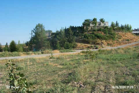 |
|
Type:
|
Mound |
|
Altitude:
|
490 m |
|
Region:
|
Southeastern Anatolia |
|
Province:
|
Sanliurfa |
|
District:
|
Birecik |
|
Village:
|
Surtepe |
|
Investigation Method:
|
Excavation |
|
Period:
|
EBA I |
|
|
|
 |
|
| The mound lies west of Sanliurfa; northwest of Birecik; on north bank of Euphrates; in Surtepe village. It covers a total area of 7.2 hectares and measures 250x230 m including the terraces. The cone of the mound has a height of 16 m and a diameter of 120 m. Based on the studies the occupied area of the mound could be from 20 to 50 hectares. It is discovered by Algaze's team during the 1989 survey within the area that is to be inundated by Birecik Dam. Salvage excavations were carried out in 2000-2001 by the joint team of the Spanish Archaeological Mission in Turkey/University of Alicante; Later Prehistory Section; Spain; and in coordination with the museum of Sanliurfa; and the Oriental Institute and Academy of Science; Prague; Czech Republic. In 2000 excavations; Middle-Chalcolithic/Ubaid; Late Chalcolithic and Early Bronze remains were reached. Surtepe seems to be occupied during the Halaf period; at least on the northern part of the mound. The site has yielded a long sequence of fourth millennium BC Late Chalcolithic levels. The site also includes levels of the Late Iron Age/Achaemenid Period. From the trench on the western slope of the settlement typical EBA I reserved slip and cyma recta ceramics were found [Fuensanta et al. 2002:199]. In 2008 work took place in the south and southeast sections of the site. There does not seem to be any break between the Ubaid and Uruk here, as is also the case at other sites in Syria and southeastern Turkey. There is also continuity from Late Chalcolithic Uruk into EBA I. One room excavated this year was in use for a long time as there were many replasterings. It contained horn cores and evidence of bone working, an Uruk IV seal and Canaanite blades. The bricks are indistinguishable from those in EBA I buildings elsewhere on the mound. An EBA I rubble platform and a number of pits were excavated. Seal impressions and cylinder seals were found, and the pottery included reserved slip wares [http://www.une.edu.au/cat/sites/surtepe.php, 22.6.2010; 14:59]. It takes place in the registered archaeological sites list prepared by Ministry of Culture and Tourism. |
| Location: The mound lies west of Sanliurfa; northwest of Birecik; on north bank of Euphrates; in Surtepe village. |
| Geography and Environment: It covers a total area of 7.2 hectares and measures 250x230 m including the terraces. The cone of the mound has a height of 16 m and a diameter of 120 m. Based on the studies the occupied area of the mound could be from 20 to 50 hectares. The houses of Surtepe village were built over the mound and its eastern and southeastern foots were eroded by the river. The secondary village road has cut the northern and western slopes. |
| History: |
| Research and Excavation: |
| Stratigraphy: |
| Small Finds: |
| Remains: |
| Interpretation and Dating: |