|
©The Archaeological Settlements of Turkey - TAY Project
|
|
|
|
|
|
Pinarbasi - Bor |
|
|
For site maps and drawings please click on the picture...  |
For photographs please click on the photo... 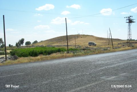 |
|
Type:
|
Mound |
|
Altitude:
|
1155 m |
|
Region:
|
Central Anatolia |
|
Province:
|
Nigde |
|
District:
|
Bor |
|
Village:
|
Merkez |
|
Investigation Method:
|
Excavation |
|
Period:
|
|
|
|
|
 |
|
| The mound lies southwest of Nigde; approximately 5 km west-northwest of Bor district; on the left side of the Ankara-Bor-Nigde highway; at the point where the road bends slightly towards the west. The 8 m high conical mound has a diameter of 100 m (including the skirts) and the cone measures 50x30 m (according to S. Omura; the height is 15.5 m) [Todd 1980:43; Silistreli 1984:81; Omura 1992:84]. The mound is surveyed by various archaeoliogists in years 1938; 1957; 1961; 1964-67 and a season-long excavation is conducted by U. Silistreli from the University of Ankara in 1982. Despite the Chalcolithic Age pottery finds yielded by surface collecting [Todd 1980:43]; solely a Neolithic Age settlementĞdestructed by Islamic burialsÑ is exposed under the level dating to the first half of the1st Millennium BC [Silistreli 1984:81-83]. It is listed in the registered archaeological sites inventory prepared by Ministry of Culture and Tourism. |
| Location: The site lies southwest of the city of Nigde; 3 km west-northwest of the town of Bor; on the left (southern) side of the Ankara-Bor-Nigde highway; in the area where the road slightly swerves to the west. In another publication; however; the mound-site is described as being on the northern side of the highway[Todd 1980:fig.17-20]. |
| Geography and Environment: It is reported that the mound site of Pinarbasi; which lies in the northern part of the fertile Bor Plain; is 8 m high and has a 100 m diameter (Omura reports that the mound is 15.5 m high [Omura 1992:543]). With the exception of the 30x50 m conical hill on top; the mound is round and flat. It has been proposed that the mound continues on the other side of the highway since pottery was found in the garden of the regional headquarters of the Highway Department; on the opposite side of the road. The highway may have thus destroyed part of the northern skirts of the mound. There is a spring; which feeds a lake or at least a river; in the rock outcrop on the northeastern side of the mound. The local name for the mound "Pinarbasi Höyük"; which literally means "head of the spring mound"; refers to this spring. Todd; Hours and other researchers have called the site Pinarbasi-Bor [Hours et al. 1994:269]. The site is surrounded by fertile agricultural fields. |
| History: |
| Research and Excavation: |
| Stratigraphy: |
| Small Finds: |
| Remains: |
| Interpretation and Dating: |