|
©The Archaeological Settlements of Turkey - TAY Project
|
|
|
|
|
|
Pinarbasi - Bor |
|
|
For site maps and drawings please click on the picture...  |
For photographs please click on the photo... 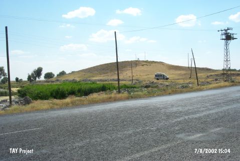 |
|
Type:
|
Mound |
|
Altitude:
|
1155 m |
|
Region:
|
Central Anatolia |
|
Province:
|
Nigde |
|
District:
|
Bor |
|
Village:
|
Merkez |
|
Investigation Method:
|
Excavation |
|
Period:
|
Ceramic |
|
|
|
 |
|
| Location: The site lies southwest of the city of Nigde; 3 km west-northwest of the town of Bor; on the left (southern) side of the Ankara-Bor-Nigde highway; in the area where the road slightly swerves to the west. In another publication; however; the mound-site is described as being on the northern side of the highway[Todd 1980:fig.17-20]. |
| Geography and Environment: It is reported that the mound site of Pinarbasi; which lies in the northern part of the fertile Bor Plain; is 8 m high and has a 100 m diameter (Omura reports that the mound is 15.5 m high [Omura 1992:543]). With the exception of the 30x50 m conical hill on top; the mound is round and flat. It has been proposed that the mound continues on the other side of the highway since pottery was found in the garden of the regional headquarters of the Highway Department; on the opposite side of the road. The highway may have thus destroyed part of the northern skirts of the mound. There is a spring; which feeds a lake or at least a river; in the rock outcrop on the northeastern side of the mound. The local name for the mound "Pinarbasi Höyük"; which literally means "head of the spring mound"; refers to this spring. Todd; Hours and other researchers have called the site Pinarbasi-Bor [Hours et al. 1994:269]. The site is surrounded by fertile agricultural fields. |
| History: |
| Research and Excavation: Surface surveys were conducted at the site in 1938 by the American Prehistorical Survey team [Gaul 1939:33]; in 1957 by K. Kökten; in 1961 by M. Ballance and by P. Meiriggi; in 1962 by D.H. French [French 1964b:37]; and in 1964-67 by I.A. Todd [Todd 1980:43]. Scientific excavations on the mound began in 1982 under the direction of U. Silistreli of the University of Ankara DTCF; Department of Archaeology. Excavations were focused on the top part of the mound and on the southern and western flanks [Silistreli 1984:81]. The total excavated areas on the mound were three 10x10 m trenches. The trench on the top of the mound was expanded by 5 m. Excavations ceased due to several reasons but especially because the mound was used as a cemetery in the Islamic Period and because it became increasingly difficult to move the burials. Another surface survey and collection of artifacts was conducted on the mound in 1990 by a Japanese research team under the direction of S. Omura; as part of their Central Anatolia Surface Survey. It takes place in the registered archaeological sites list prepared by Ministry of Culture and Tourism. |
| Stratigraphy: A complete stratigraphic sequence could not be determined in the one season of excavation conducted on the mound. The mound was used as an Islamic burial in the latest phase. These burials have damaged the underlying architectural features. The burials; which were as deep as 1.6 m; damaged the Iron Age levels in the upper and southern parts of the mound and the Ceramic Neolithic levels on the western part of the mound. The mound was probably inhabited since the Neolithic because of its fertile location and water source. The Iron Age level is 1.6 m thick. Todd also notes that there are Chalcolithic and Early Bronze Age levels at the site [Todd 1980:43]. Since Neolithic finds were found on the northern part of the mound as well; this settlement is thought to be larger than the other settlements on the mound. |
| Small Finds: Architecture: Stone foundations constructed with a single row of neatly lined stones were found in the Neolithic layers in the southern part of the mound. The mudbrick collapse suggests that the upper parts of these walls were mudbrick. Plans of the structures are rectangular. The floors of the houses have been plastered with a smooth clay plaster. The Ceramic Neolithic structures on the western part of the mound have been completely destroyed although two superimposed plaster floors; one 50 cm beneath the other; were found. The upper part of the mound was rich in architectural remains. This is the area where the most stratigraphic comprehension was achieved. A 3.1x3.1 m square room constructed with a three row high stone foundation was found. Another wall was found beyond the eastern wall of this structure; suggesting that the buildings were built close to each other. Limited information was uncovered since the excavated area was small and since the architectural remains had faced much damage. The square room which yielded an oven in its northeastern corner and a hearth in another corner is one of the few pieces of evidence of daily life of this Neolithic settlement. Pottery: The Neolithic ceramics are hand-made. Some have been made with a coarse paste and are gray; black and dark red in surface color while some made with a thin paste have been burnished. The latter includes vessels with relief decoration with stylized human faces; bulls and deer. This ware has black cores. The vessel shapes are comprised of deep and shallow bowls; one handled mugs; vessels with flaring mouths and jars [Silistreli 1984a:83]. Chipped Stone: The excavation yielded many in situ perforators; blades; knives; burins; points and other hunting tools and many debitage products. Almost all the tools have been made with dark black obsidian. The surface finds collected in Silistreli's surface survey before the excavation were studied by Renfrew and his crew. The raw materials may have been supplied from the obsidian resources at Acigöl and Çiftlik. Perhaps the most impressive example of the chipped stone industry at the site is an obsidian dagger and its bone handle. Omura and his crew also found several points during their survey at the site. Ground Stone: The number of ground stone finds at this site is less than contemporaneous sites in the region. A few grinding stones and celts as well as a bi-facial mortar; described as a frame stone by the excavation director; was also found. Bone/Antler: Bone and antler handles and many awls were found. Human Remains: Beneath the floor of the square room; not in the room itself; but beneath the wall beyond the eastern wall of this room; was a jar burial. The burial was of a child and the jar had been closed off with a stone slab. The orientation of the jar and the position of the skeleton has not been mentioned. It is also not certain whether any burial gifts were found. No other Neolithic burials were found in the excavated area. It is possible that the main graveyard is outside the settlement area. |
| Remains: |
| Interpretation and Dating: This important site has the potential to be a key site in understanding the Ceramic Neolithic of the Bor Plain. Excavations here were not completed because the excavation director preferred to excavate at the Neolithic site of Kösk Höyük; also in the Bor Plain; instead. Another reason why excavations were not continued at this site is because the mound was used as a cemetery in the Islamic Period. This damaged much of the underlying material cultural layers. The stratigraphy of the mound could not be determined in full; since virgin soil was not reached. The ceramics are a little different than the ceramics from the Konya Plain and from the Mediterranean shore. The closed vessels here are coarser. |