|
©The Archaeological Settlements of Turkey - TAY Project
|
|
|
|
|
|
Pascu Höyük |
|
|
For site maps and drawings please click on the picture...  |
For photographs please click on the photo... 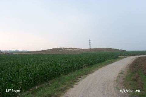 |
|
Type:
|
Mound |
|
Altitude:
|
90 m |
|
Region:
|
Mediterranean |
|
Province:
|
Osmaniye |
|
District:
|
Kadirli |
|
Village:
|
Tatarli |
|
Investigation Method:
|
Survey |
|
Period:
|
|
|
|
|
 |
|
| This site lies east of the Ceyhan-Kadirli highway; 6.2 km southwest of Tatarli Village; 20 km northeast of the town of Ceyhan; northeast of the city of Adana. It is locally known as İkiz Tepe (Twin Hills). It is a medium size mound. It is 10 m high. It has a lowland ca.17 m diameter on the top hill. It was surrounded by a swamp the year the survey was conducted. It has been replaced by fertile fields at present. It was discovered during the Cilicia survey conducted under M.V. Seton-Williams in 1951. Sherds dating from the Chalcolithic Age; the EBA; the LBA; the Hellenistic- Roman and Islamic Periods were collected from the surface. J. Mellaart includes Pascu among findspots of the metallic wares. It is rich in flintstone and obsidian finds. It takes place in the registered archaeological sites list prepared by Ministry of Culture and Tourism. |
| Location: This site lies east of the Ceyhan-Kadirli highway; 6.2 km southwest of Tatarli Village; 20 km northeast of the town of Ceyhan; northeast of the city of Adana. It is locally known as Ikiz Tepe (Twin Hills). |
| Geography and Environment: The site lies along a stream bed of now completely dried stream which used to empty into the Ceyhan River. It is a medium sized mound 10 m in height. |
| History: |
| Research and Excavation: |
| Stratigraphy: |
| Small Finds: |
| Remains: |
| Interpretation and Dating: |