|
©The Archaeological Settlements of Turkey - TAY Project
|
|
|
|
|
|
Öküzini Magarasi |
|
|
For site maps and drawings please click on the picture...  |
For photographs please click on the photo... 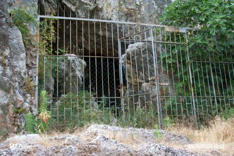 |
|
Type:
|
Cave |
|
Altitude:
|
250 m |
|
Region:
|
Mediterranean |
|
Province:
|
Antalya |
|
District:
|
Merkez |
|
Village:
|
Yagca |
|
Investigation Method:
|
Excavation |
|
Period:
|
ÜP EP |
|
|
|
 |
|
| Location: The cave-site lies 32 km northwest of the city of Antalya; north of the village of Yagca; 1.5 km north-northeast of Karain Cave. The site is very close to the old Antalya-Burdur highway passes. The survey code of the site is 19 V / 2. |
| Geography and Environment: The mouth of the cave; which lies 4-5 m above the travertine in front of it; faces east-northeast. There is another cavity beyond the 23.5 m long main cavity. The cave is roughly triangular in shape. The mouth of the cave is 25 m wide [Harmankaya-Tanindi 1996: Öküzini]. |
| History: |
| Research and Excavation: In 1956; the year he discovered Öküzini; Kiliç Kökten opened a small test trench by the mouth of the cave. Scientific research at this site was halted until Yalçinkaya resumed excavations 1989; under the auspices of the Antalya Museum. The trench opened by Kökten was 2.5x1.5 m in size and was excavated to 2.52 m beneath the surface. This excavation yielded a total of five cultural layers. Kökten assigns the first two layers to the Early Bronze Age II; the third layer to the Chalcolithic; the fourth layer to the Neolithic and the fifth and final layer to the Upper Palaeolithic Period. In 1984; before she began her excavations here; Yalçinkaya sifted Kökten's spoil and recovered 356 artifacts. After having cleaned Kökten's sections in 1989; excavation began under Yalçinkaya's direction with a team of multi-national specialists. The scientific excavation involved mapping the cave and making a grid-plan of the site (for more information on this research see Yalçinkaya 1992:56-57). The grid extended vertically as well; where a new archaeological layer was defined every 10 cm. Excavations led jointly by Yalçinkaya and M. Otte from Liége University are currently continuing. It takes place in the registered archaeological sites list prepared by Ministry of Culture and Tourism. |
| Stratigraphy: The researchers conclude that the stratigraphic sequence is as follows: Phase 1: This phase; dated to ca.16.500 B.P.; is the earliest at the site. Faunal assemblage includes fallow deer and goat. Phase 2: The faunal assemblage in the phase following a 1.000 year hiatus; ca. 15.500 B.P.; included goat and sheep. Phase 3: In addition to goat hunting; which continues in the third phase; dated to ca. 14.500 B.P.; deer re-enters the faunal assemblage. Phase 4: There is a noted difference in chipped stone tool technology and cave-art in this phase. Microlith tools become geometric and there is an increase in fallow deer and sheep hunting. The faunal assemblage also includes goat; roe-buck and red deer. Phase 5 discovered immediately beneath the modern cave-floor has been confidently assigned to the Neolithic Period while the graves of Phase 6 are Neolithic and Chalcolithic in date [Yalçinkaya et al. 1997:11-13]. Yalçinkaya believes that the data may shed light on the transitional stage from hunting and gathering to food production. |
| Small Finds: Kökten explains that the earliest layers yielded Upper Palaeolithic tools; although he does not describe them. Yalçinkaya; on the other hand; reports that Phase 1 yielded tools mostly with straight backs; but also some with noticeable ridges. She further notes that end scarpers on blades were found in this phase. Phase 2 was rich in long triangles used as arrow-heads and backed bladelets while the artifacts of Phase 3 included cores with striking platforms; backed bladelets; multi-notched blades; end scrapers on blades and irregular microliths. The most important finds; aside from the chipped stone tools from Phase 4; are the incised river pebbles found by Kökten; which he believes are Aurignacien III-IV. One of the pebbles has a hunting scene on both faces. While one face depicts a hunting band; the other portrays a trap [Kökten 1962: 4I; table III; fig.1]. The replica of the ox or bull engraving on the cave wall is incised on another pebble. Other pebbles with what appear to be human figures have also been found. Similar incised pebbles were also found in Phase 4 of Yalçinkaya's excavation. The chipped stone tools from this phase include geometric microlith tools; irregular blades used for microlith production and pyramidal cores. Grinding stones found in this phase indicate that the inhabitants had begun processing wild grains. Phase 4 is dated to ca. 12;500 B.P. Engraved bones; pierced sea-shells probably used for decoration; a necklace made from the incisors of a fallow deer; rhyolite flat and circular pierced beads; and fragments of ocher were found. Bone tools include awls of a variety of sizes and styles; which suggests that leather-working was a practiced craft. It would be more accurate to place the levels Kökten assigned to the Aurignacien into the Epipalaeolithic. |
| Remains: |
| Interpretation and Dating: |