|
©The Archaeological Settlements of Turkey - TAY Project
|
|
|
|
|
|
Asarkaya |
|
|
For site maps and drawings please click on the picture...  |
For photographs please click on the photo... 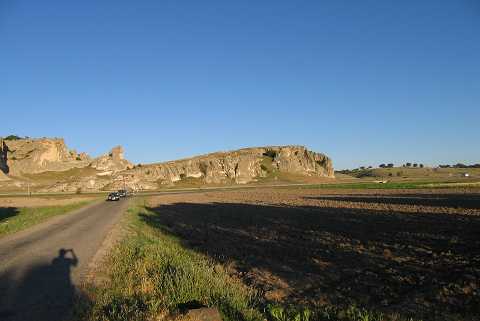 |
|
Type:
|
Flat Settlement |
|
Altitude:
|
965 m |
|
Region:
|
Aegean |
|
Province:
|
Kütahya |
|
District:
|
Merkez |
|
Village:
|
Sabuncu |
|
Investigation Method:
|
Survey |
|
Period:
|
EP |
|
|
|
 |
|
| Location: This site lies northeast of the city of Kütahya; 2 km south of the town of Sabuncular; in the area known as Asarkaya. |
| Geography and Environment: The geographical information provided by the researcher indicates that Asarkaya is a rock outcrop which lies on the northwestern skirts of Mount Türkmen. The finds were found on a slope of the rock outcrop and on the flat area beside it. The region is abundant in natural caves; which must have been attractive shelters for the first producers. |
| History: |
| Research and Excavation: Many chipped stone tools were collected in Turan Efe's 1988-89 surface survey of the Kütahya-Eskisehir-Bilecik area. It takes place in the registered archaeological sites list prepared by Ministry of Culture and Tourism. |
| Stratigraphy: |
| Small Finds: Efe does not provide in-depth information about the chipped stone tools he found. The site is thought to date either to the Epipalaeolithic or to the Aceramic Neolithic but both assignments should be viewed with scepticism. |
| Remains: |
| Interpretation and Dating: |