|
©The Archaeological Settlements of Turkey - TAY Project
|
|
|
|
|
|
Karatas Semayük |
|
|
For site maps and drawings please click on the picture...  |
For photographs please click on the photo... 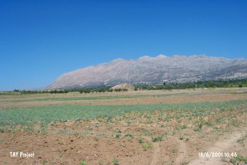 |
|
Type:
|
Mound and Cemetery |
|
Altitude:
|
1140 m |
|
Region:
|
Mediterranean |
|
Province:
|
Antalya |
|
District:
|
Elmali |
|
Village:
|
Bozhüyük |
|
Investigation Method:
|
Excavation |
|
Period:
|
EBA II EBA I |
|
|
|
 |
|
| Location: It lies west of the Bozüyük (Semayük) Village; some 6 km east of the Elmali District; west of the Antalya Province. Elmali-Korkuteli motorway passes 5.1 km west of the mound. It is called Karatas-Semayük in order to prevent any confusion with the mound of Semayük. |
| Geography and Environment: Karatas is located immediate east of the Elmali-Korkuteli motorway on the Elmali Plain; 1200 m high from the sea level; surrounded by the Taurus Mountains. It measures 3-4 m in height and 100 m in diameter. The excavations yielded a settlement and a cemetery. |
| History: |
| Research and Excavation: It was investigated by S. Hood in 1949 and J. Mellaart in 1951-52; and excavated by a team under M.J. Mellink between 1963 and 1974. It takes place in the registered archaeological sites list prepared by Ministry of Culture and Tourism. |
| Stratigraphy: As a result of the excavation; six layers; all dating to EBA; classified from I to IV in ascending order were identified. Layer V is divided into three sub-phases. |
| Small Finds: Architecture: It can be inspected in two parts; the main settlement on the mound and the extramural settlement. In the layer I of the main settlement; a single row of remains of a big; rectangular building; 10.75x7.20 m was discovered. It is built by mudbrick on a stone socle. The floor and the walls are plastered. The wall thickness is nearly 80 cm. The courtyard surrounded by the fortification wall encircles the building. The inner surface of the walls is supported by bastions. The city walls were enlarged twice to serve as a fortification of 4-5 m thick. To the south section lies a ramp paved with cobbles. It is supported by the city walls. The city walls consist of diagonally placed mudbricks on a stone socle; and are supported by bastions on the outer surface. Outside the city wall; there is another set of twin city walls built in wattle and daub technique. Between those walls lie the houses. Beside these walls and the houses; ditches surround the mound. The layer 1 was destroyed by a massive fire. In the layer II; the rectangular building was renewed and the whole complex was repair. After the demolition of the layer II by a fire; the settlement was flattened in the layer III. The main structure remained same with minor changes. There is accumulation of ashes especially on the southeastern part of the mound. By the end of the layer III; a new fortification wall was built towards the foothill; and it was renewed in the layer IV. In the layer IV; a new fortification wall was built instead of the oval fortification wall in the first layer. Built by "Pise" technique; it is 3 - 5 m thick and called the"White Wall". The fortification wall is pierced by a gate supported with a tower. The settlement was abandoned for a while after the layer IV. A cobble paved ramp was built to the east of the mound and hearths were placed alongside this ramp during the last settlement in the layer V. A well found in the northern foothill indicates that the main settlement continued in this layer as well. The architectural remains of the extramural settlement were found on the north and southeast of the mound in the layers I - III. Circular huts and pits belonging to layers I and II were found. Layer III yielded apsidal buildings with stone foundations. Some are megaron-like. The architectural remains of the extramural settlement were uncovered in the layer IV right on the southeastern foothill. Two wide megarons on stone foundation and remains of rectangular buildings were found. A horseshoe-like hearth was recovered from a building. Many firepits were recovered; irrelevant of the buildings. The extramural settlement was highly enlarged in layers V and VI. In the layer V; the buildings are made of mudbrick on a stone socle. The walls were renewed several times. Some of the rectangular buildings are megaron-like. The houses built near to each other were usually placed on the northwest-southeast direction. Compared with the other ones; the buildings of the layer VI were erected more neatly. They are megaron-like; some built by mudbricks on stone foundations. Some have hearths in the middle. Also stone platforms were found outside the houses. Pottery: Up to the end of the third structure level of the layer V; all pottery is handmade. The red burnished ware is introduced at layer V; and wheel-made buff colored ware appears in layer VI. Unrolled; deep or shallow flat bowls are the most common forms. Some bear handles on the rims. Basket handles are observed. Another common form is single handled; long necked pitchers. Some are spouted. Double handled globular shaped forms are also common. The structure level 3 of the layer V yielded single handled cups; while double handled cups; depas; krater; high lid and plate forms appear at layer VI. The bottoms of the vessels are usually flat; but some have high and low pedestals. As decorations; incisions and reliefs are common. The relief with a human face depiction applied on the neck of a globular vessel is unique. From the layer IV; matt white paint is applied on darker ware whereas it is applied on red burnished ware from the layer V/1 Clay: Spindle-whorls; some decorated; were recovered. Also found are loomweights; linearly decorated stamp seals and terra cotta animal figurines. Ground Stone: Polished stone axes; hammers and maces were found. A decorated hammer made of limestone is unique. Many grinding stones and mortars were recovered. There are many violin-shaped idols made of limestone and various stones. Human Remains: The excavations yielded cemeteries on the south and southeast of the settlement. 386 pithos graves were uncovered on the south while 59 on the southeast. Most of the burials belong to the layers IV and V. The openings of the pithos graves usually face the east. They are capped with big flat stones; and then marked with stones forming a circle to identify their positions. Grave Goods: The burials are accompanied with grave goods such as pottery; metallic and clay items. 74 graves yielded finds in bronze and silver. Furthermore; golden beads and earrings were found in an infant's grave. Other finds include daggers; blades; pins and needles; bracelets; rings and razor. The metallic finds of the cemetery were analyzed by L.A.Bordaz (Bordaz 1978). Among them; the zoomorphic headed pin is unique. It is obvious that one of the burials had been through a trepanation surgery resulted with a failure. |
| Remains: |
| Interpretation and Dating: Extensively excavated; Karatas-Semayük is one of the most significant EBA settlements of the Southwestern Anatolia. Although there are many publications on it; they lack detailed data. All remains relating to all EBA layers have been brought to light (Mellink 1985:103-104). The cemetery was in use starting from EBA I. The most intensive occupation of the cemetery was in the layer V during EBA IIa. Karatas I-V is compared with Troy I while Karatas VI with Troy II. No graves were found dating to EBA III. There are a series of 14C dates relating to the main settlement of the layer II. The available date is in the range between 2900 and 2600 BC. |