|
©The Archaeological Settlements of Turkey - TAY Project
|
|
|
|
|
|
Karamusa |
|
|
For site maps and drawings please click on the picture...  |
For photographs please click on the photo... 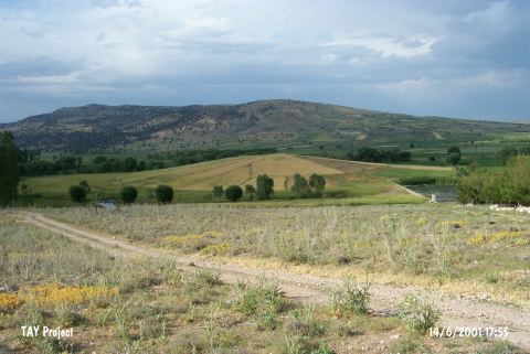 |
|
Type:
|
Mound |
|
Altitude:
|
1320 m |
|
Region:
|
Mediterranean |
|
Province:
|
Burdur |
|
District:
|
Tefenni |
|
Village:
|
Karamusa |
|
Investigation Method:
|
Survey |
|
Period:
|
|
|
|
|
 |
|
| It lies approximately 200 m north of Baspinar-Çavdir road; notrhwest of Baspinar Village; 2 km southeast of Karamusa Village; south-southeast of Tefenni Distict of Burdur. Immediate east of the site there is a well spring called Kirkgöz. It is ca. 5 m high. The survey conducted by M. Özsait yielded pottery of the EBA and the Late Neolithic-Early Chalcolithic Ages. It takes place in the registered archaeological sites list prepared by Ministry of Culture and Tourism. |
| Location: It lies approximately 200 m north of Baspinar-Çavdir road; northwest of Baspinar Village; 2 km southeast of Karamusa Village; south-southeast of Tefenni District of Burdur. Immediate east of the site there is a well spring called Kirkgöz. |
| Geography and Environment: This mound; discovered by M. Özsait; is continually eroding. The mound lies beside the spring at the northern skirts of 1;666 m high Mount Düvenkaya. The current height of the mound is 5 m Özsait notes that there was continuous habitation at the site from the Late Neolithic Period on through to the Iron Age. In the photography published with the survey report; the mound appears to be small and flat looking. |
| History: |
| Research and Excavation: |
| Stratigraphy: |
| Small Finds: |
| Remains: |
| Interpretation and Dating: |