|
©The Archaeological Settlements of Turkey - TAY Project
|
|
|
|
|
|
Karaagaçtepe |
|
|
For site maps and drawings please click on the picture...  |
For photographs please click on the photo... 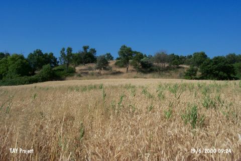 |
|
Type:
|
Mound |
|
Altitude:
|
10 m |
|
Region:
|
Marmara |
|
Province:
|
Çanakkale |
|
District:
|
Eceabat |
|
Village:
|
Seddülbahir |
|
Investigation Method:
|
Excavation |
|
Period:
|
EBA I EBA II |
|
|
|
 |
|
| Location: It lies 3 km northeast of the Seddülbahir Village on the Gelibolu (Gallipoli) Peninsula; southwest of the Eceabat District of the Çanakkale Province. It is coded under H 1/2. |
| Geography and Environment: It is located at the end of the Gallipoli Peninsula. It is also known as tumulus of Protesilaous who fought the Trojans. It lies 1 km far from the Gulf Morto; on the northern bank of the Kirte Stream. It measures 8 m in height and 100-126 m in diameter [Schliemann 1884:draw. at 133]. Terrace walls were seen on the slopes when it was surveyed by H. Schliemann. The settlement is located in a small valley of fertile lands. It is surrounded by fields. |
| History: |
| Research and Excavation: In 1882 H. Schliemann; who believed the mound was a tumulus; opened a trench and excavated to a depth of 2.5 m from the surface. After the First World War; in 1921-23; French Occupying Forces conducted an excavation on the mound under the direction of R. Demangel. In 1982; the site was systematically surveyed by a team led by M. Özdogan during their survey of the Gallipoli Peninsula. It takes place in the registered archaeological sites list prepared by Ministry of Culture and Tourism. |
| Stratigraphy: The excavations carried out between 1921-1923 yielded a deposit of 11.5 m thick. 1.5 m of this thickness on the top is dated to the Byzantine Period; and 4th and 3rd building levels to EBA; Troy II 2nd building level to EBA; Troy I 1st building level to Kumtepe Ib. It is also reported that surface collection carried out by M. Özdogan in 1982 yielded pottery belonging to the Neolithic Age. |
| Small Finds: Architecture: No detailed information is available about the architecture. 2nd building level; between 7.30 and 6.00 m depths; has two sub-phases which both were demolished by a massive fire. Between 7.30-7.10 m; a layer comprising red clay and coal was found; overlapped by a pile of stones collapsed. Between 6.5-6.30 m; a layer of ashes and burnt earth covered by a red clay band and cobbled sand was found. Beneath the red clay band; a line of black coal sometimes interrupted by big stone blocks is visible. Pottery: Pottery of 2nd building level dated to Troy I is handmade and burnished in dark colors varying from black to gray. Forms of bowls with unrolled rims or interiorly thickened rims; jugs; pithoi and lids are common. Incision; channel or plastic decorations are seen. The 3rd and 4th building levels yielded very typical pottery of Troy II [Schliemann 1884:26]. Out of those pottery; tankards with long bodies which are called depas amphikypellon by H. Schliemann are very typical. Vast majority of them is washed in thick red and polished. Clay: Spindle whorls and loomweights in terra cotta were found. Ground stone: Polished stone axes; grinding stones; pestles; a baton with a serpentine head and shaft-holed hammer were recovered. Metal: A bronze pin belonging to Troy II was recovered. H. Schliemann provides drawing of a dagger with a folded tip in bronze which is unique among its type. |
| Remains: |
| Interpretation and Dating: It is located at the end of the Gallipoli Peninsula. It is one of the major EBA settlements in this region. Materials of Karacaagaçtepe presently preserved at the Istanbul Archaeological Museum should be re-published in detail. |