|
©The Archaeological Settlements of Turkey - TAY Project
|
|
|
|
|
|
Karaagaçtepe |
|
|
For site maps and drawings please click on the picture...  |
For photographs please click on the photo... 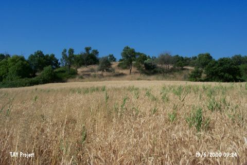 |
|
Type:
|
Mound |
|
Altitude:
|
10 m |
|
Region:
|
Marmara |
|
Province:
|
Çanakkale |
|
District:
|
Eceabat |
|
Village:
|
Seddülbahir |
|
Investigation Method:
|
Excavation |
|
Period:
|
Late |
|
|
|
 |
|
| The medium; 8 m high mound; 100 m in diameter; lies southwest of Çanakkale; approximately 3 km north-northeast of Seddülbahir village; 1 km from Morto Bay. It was also published as the Tumulus of Protosilas. H. Schliemann excavated the site in 1882 assuming that it was a tumulus. Excavations were conducted by R. Demangel in 1921-23. A 4.5 m thick layer revealed Kumtepe Ib finds. The earliest settlements in Gelibolu are thought to be dating to the Late Chalcolithic Age and even earlier phases. The location code of the site is H 2 / 1. It takes place in the registered archaeological sites list prepared by Ministry of Culture and Tourism. |
| Location: It lies 3 km northeast of the Seddülbahir Village on the Gelibolu (Gallipoli) Peninsula; southwest of the Eceabat District of the Çanakkale Province. It is coded under H 1/2. |
| Geography and Environment: It is located at the end of the Gallipoli Peninsula. It is also known as tumulus of Protesilaous who fought the Trojans. It lies 1 km far from the Gulf Morto; on the northern bank of the Kirte Stream. It measures 8 m in height and 100-126 m in diameter [Schliemann 1884:draw. at 133]. Terrace walls were seen on the slopes when it was surveyed by H. Schliemann. The settlement is located in a small valley of fertile lands. It is surrounded by fields. |
| History: |
| Research and Excavation: |
| Stratigraphy: |
| Small Finds: |
| Remains: |
| Interpretation and Dating: |