|
©The Archaeological Settlements of Turkey - TAY Project
|
|
|
|
|
|
Harran |
|
|
For site maps and drawings please click on the picture...  |
For photographs please click on the photo... 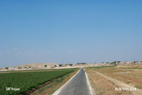 |
|
Type:
|
Mound |
|
Altitude:
|
400 m |
|
Region:
|
Southeastern Anatolia |
|
Province:
|
Sanliurfa |
|
District:
|
Harran |
|
Village:
|
Merkez |
|
Investigation Method:
|
Excavation |
|
Period:
|
EBA III EBA II EBA I |
|
|
|
 |
|
| Location: It lies almost in the middle of Harran town; 44 km southeast of the Sanliurfa Province. It can be easily accessed from the Sanliurfa-Harran motorway. |
| Geography and Environment: It is partly obscured by the modern town. It is one of the hundreds of settlements located on the lowland of Harran with a size of 30x50 km; on the upper part of the Balih/Belih Valley. 250 mounds were identified as a result of surveys conducted by V. Sevin and particularly by N. Yardimci in this plain [Özfirat 1994: map. 1-2]. It is situated at the joint of the caravan road running from Mesopotamia to Central Anatolia through the Samsat-Malatya motorway; and to the west; the Mediterranean region through Karkamis. Therefore; it is a cult center of Kura during the third millennium BC and of Sin (god of moon) during the second millennium BC. The inscriptions expose that it developed and became a center for cultural activities in the later periods. It is surrounded by fertile arable fields; but it is poor in water resources. The Cullap Suyu originating from Urfa passes by Harran and joins the Euphrates through the Balih Stream. This stream is usually dry in summer time. |
| History: |
| Research and Excavation: S.Loyd and W. Brice conducted a survey at Harran in 1950. Between the years 1959 and 1983 D.S. Rice launched an excavation project that was followed by a team led by N. Yardimci until 2011. Since 2014, M. Önal has been leading the excavations at Harran. The deep sounding carried out by D.S. Rice was on the eastern slope of the mound; south of the mosque. The sounding started in an area of 6x15 m was confined through the deep and ended at ca. 10 m depth with a size of 1x1-2 m [Prag 1970:profil at fig. 2; 3]. The height of this trench was miscalculated as it took the floor of the plain as level 0. The upper diameter of the trench is 26.59 m while the bottom is 16.50 m. The stratification is based on these measurements. The excavations carried out under N. Yardimci were mainly concentrated on the illumination of the Turkish-Islamic Period. It takes place in the registered archaeological sites list prepared by Ministry of Culture and Tourism. |
| Stratigraphy: Both the excavations and the survey suggested that the site had been inhabited more or less continuous from the fifth millennium BC until the Eyyubi Period. The excavations carried out under N. Yardimci were mainly concentrated on the illumination of the Turkish-Islamic Period. The prehistoric stratification of the mound was only obtained by a deep sounding carried out by Rice. The virgin soil was not reached. The settlement of Chalcolithic Age (first layer) was evaluated depending on the surface finds [See Harmankaya et al.1998:Harran]. The EBA stratification of the deep sounding is presented depending on the finds and the sections of the sounding [Prag 1970:71-72]: Layer II: Between 16.50-29.30 m: Early Dynasty II-III with 2 building levels Layer III: Between 19.30-22.00 m: end of EBA (Akkads or Ur III period) with 3 building levels Layer IV: Between 22.00-23.50 m: Ur III Period/Transition Period (EBA to MBA) Layer V: This flooded layer yielded mixed material varying from EBA to Islamic Period. |
| Small Finds: Architecture: The information about the EBA architecture is not much. Layer II dated to Early Dynasty II-III yielded remains of semi-rectangular buildings with rounded mubrick walls on stone foundations. Small and four-cornered rooms were found. Layer III; out of layers III and IV dated to the Sargon or Ur III period; revealed an extensive mudbrick building without any stone foundation while the layer IV yielded small mudbrick structures; but incomplete plans due to the inefficiency of the excavated area. Pottery: The analysis of the pottery recovered from the deep sounding carried out by Rice yielded sherds and limited number of intact vessels of the fine ware; identified as stoneware; early Khabur ware and the buff colored plain ware at layer II. The samples of fine ware are handmade; thin pasted in light or dark gray and red; well fired and slightly burnished [Prag 1970:78; fig.7/26; 27; 29-37]. It is found in large quantities at 18.80 m depth. Ewer; bowl; pot; vessels with narrowing rims are produce of this ware. Prag reports that likes of these samples are also found at the settlements of Asagi Yarimca; Tell Chuera; Tell Brak; Sagar Pazar; Arbit and Mezan. The Early Khabur ware is wheel-made; self-slipped; very thin walled like eggshell; well fired; colored in a variety ranging from pink to gray. Some are decorated with bands in matt orange or red paint. The most common form is pot [Prag 1970:70]. Samples of this ware were found between 17.80-19.50 m at Harran. Some other vessels of this ware seen at Early Dynasty II-III of Mesopotamia were also found at the chamber grave of Til Barsib; Mari and EBA II level of Gözlükule dated to 2700-2400 BC; Hammam Cemeteries and Amama. Samples of the buff colored plain ware are rare. Sherds of this ware were also found in the excavations of the Amuq Plain. Gray colored; spiral ring decorated ware is represented by a few samples only [Prag 1970:fig.7:28]. It is dated to the end of EBA. The burnished kitchen ware [Prag 1970:81; fig.8/54-55] originates from Anatolia. It is also found at Karkamis; Fethiye; Phase I of Amuq and Tell Tayinat. The layers III and IV of Harran are dominated by the combed decorated and washed ware [Prag 1970:83; fig.8/47-53]. The decorations of this dark red; black; eggplant purple brown; light red painted ware on a handmade; greenish buff; pink orange waved greenish mottled background were probably applied like incisions by using a tool like a comb. Samples of this ware were found at Tell Brak; Zibini Höyük of Sanliurfa; Phases I and J of the Amuq Plain. Clay: Harran is claimed to be the findspot of an idol; animal figurine and car models brought to Ashmolean Museum in 1965 and 1968. Some of these terra cotta objects are colored in greenish buff and others in yellowish gray. Usually they are well fired [Prag 1970:86-87; fig.9-10]. Some are dated to phase III or IV. |
| Remains: |
| Interpretation and Dating: The deep sounding of Rice has only laid out the presence of layers dating from the midst and end of the third millennium BC at Harran. Conversely; the inscribed clay tablets recovered from the mound of Tell Mardik (Ebla city of the third millennium BC) in Syria provided very significant and actual information about the social and administrative life of Harran during EBA. These tablets dating from the 24th century BC revealed that the former name of Harran was; probably; deriving from "Hara-an ki" meaning "road" and it was ruled in an monarchy by a local family [Archi 1988:1]. It is quoted together with the cities of Urshun and Irrite located in the vicinity of Gaziantep in the Ebla tablets [Yardimci 1998:169]. The kingdom of Ebla was even extending to the north of Kargamis. It is learnt that the management consisted of; aside the queen; a representative of the king and a board of aged people [Özfirat 1994:36]. The person close to the king or the representing the king was called "Badalum" according to these tablets. During this century; Harran was ruled by a queen named Zugalum. Ebla inscriptions revealed that the queen was given presents such as cosmetic oils and cloths during her visit to Ebla; and the bagalum was given gold ingots and a curved dagger in silver. When the queen Zugalum gave a birth; she was sent presents and asked to organize ceremonies to the name of the god Kura. It is known that Harran sent silver to Ebla in exchange. Those texts expose that Harran was not a simple city during EBA III and housed a significant settlement ringed by fortification walls including temples and the queen's palace. As the excavations continue; more will be brought to light with uncovered buildings of the city. The thick deposit of the upper settlements and their significance will delay reaching out to the lower layers in a wide area. Therefore; the remains of the upper levels should be sacrificed. |