|
©The Archaeological Settlements of Turkey - TAY Project
|
|
|
|
|
|
Turgut / Lagina |
|
|
For site maps and drawings please click on the picture...  |
For photographs please click on the photo... 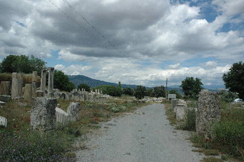 |
|
Type:
|
Cemetery |
|
Altitude:
|
420 m |
|
Region:
|
Aegean |
|
Province:
|
Mugla |
|
District:
|
Yatagan |
|
Village:
|
Turgut |
|
Investigation Method:
|
Excavation |
|
Period:
|
|
|
|
|
 |
|
| It is situated approximately 10 km northwest of the Yatagan District in Mugla. The first excavations were conducted between 1891 and 1893 by Osman Hamdi Bey. Excavations conducted by Y. Boysal in between 1967 and 1970 were followed by excavations led by A. Tirpan in between 1993 and 2011. Excavations at Lagina started again in 2017 under the directory of B. Sögüt. Turgut/ Lagina is listed as an officially registered archaeological site by the Ministry of Culture and Tourism. The Geometric Period sherds found in the Bozukbag Cemetery Area were dated from 730 to 680 BC by C. Özgünel. It takes place in the registered archaeological sites list prepared by Ministry of Culture and Tourism. |
| Location: It is located; 10 km northwest of Yatagan district; 1 km away from Turgut; 15 km northwest of the Yatagan District of the Mugla Province. It is 9 km far from the ancient city of Stratonikeia [Tırpan 1996:209]. It is reported that it was formerly known as Leyne in the archaeological literature until 1979 [Boysal 1979:389]. |
| Geography and Environment: It is located on a fertile land in the Valley of the Cine Brook [Boysal 1979:389]. |
| History: |
| Research and Excavation: |
| Stratigraphy: |
| Small Finds: |
| Remains: |
| Interpretation and Dating: |