|
©The Archaeological Settlements of Turkey - TAY Project
|
|
|
|
|
 |
Lopadion (Ulubat) Kalesi |
|
|
|
|
For site maps and drawings please click on the picture...  |
For photographs please click on the photo... 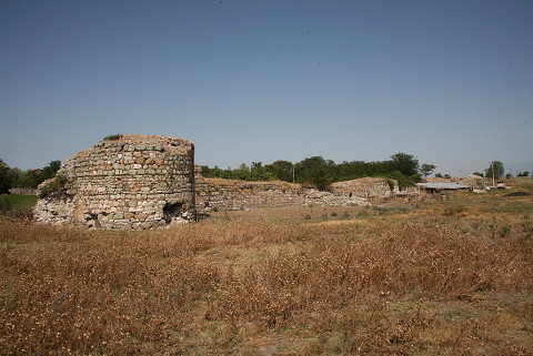 |
|
|
|
|
Type:
|
Fortification |
|
Plan Type:
|
Rectangular |
|
Year of Costruction:
|
1130 |
|
Phase:
|
Middle |
|
Investigation Method:
|
Survey |
|
Altitude:
|
10 |
|
|
|
|
Region:
|
Marmara |
|
Province:
|
Bursa |
|
District:
|
Karacabey |
|
Village:
|
Uluabat |
|
Antique Name:
|
Lopadion |
|
|
|
  |
|
| The fortress situated in the Uluabat Village to the west of the Uluabat (Apolyont) Lake, 4 km to the east of the Karacabey District in Bursa was in control of the ancient Mysia Plains on the Orhaneli Brook, which is a branch of the Susurluk Brook. The fortress lies on a very strategical location on the Bursa-Çanakkale highway [Giros 2003:213, no. 39]. It was first seen by F.W. Hasluck in the early 20th century [Hasluck 1910:78-83], and then was visited by C. Foss during the survey he conducted [Foss-Winfield 1986:145-146]. The city walls measure 475x150 m. The towers are of different sizes with a distance of 30 - 40 m from each other. The masonry of the fortress and its gates are very simple and plain, and the architectural elements differ from the conventional masonry techniques. Based on this, C. Foss proposes that it was an assembly area for the Byzantine troops rather than a fortress in the classical sense [Foss-Winfield 1986:145]. Courses of mid-size stones and use of small rubble stones are observed on the façade of the extant tower. However, the courses of stones are irregular. Each course is usually limited by a single row of bricks. Although some bricks are vertical, it has a regular sight of "cloisonné" technique. The original heights of the towers were shortened, and new towers were added at some points to the east. Lopadion was probably surrounded by a city wall during the 11th century [Bondoux 2003:392-394]. The fortress was rebuilt by the Emperor John II Komnenos in 1130. The fortress has a gate on the northeast side. The tower at the gate was well preserved. The cover system of this tower, its lento and jamb are in tact. It was observed that the the fortress was partially made of reused material [TAYEx 08.07.2008]. |
| Location: |
| Geography and Environment: |
| Research and Excavation: |
| Description: |
| Finds: |
| Interpretation: |
| Destruction: Illicit digging was performed in front of the east wall inside the tower at the entrance. A gate was built at the entrance by laying bricks used with cement. There are spaces used as cotes on the south side of the fortress outside the wall. One of the towers is also being used as a cote. Illicit diggings were encountered on the northeast and west side of the fortress facing outside. Housing is observed in the west of the structure [TAYEx 08.07.2008]. |

