| ©The Archaeological Settlements of Turkey - TAY Project | ||||||
|
|
||||||
Göbekli Tepe Ziyareti |
||||||
|
|
||||||
| Ages | Maps | Photos | ||||
| Neolithic 14C |
 |
 |
||||
|
|
||||||
|
Type:
|
Mound | |||||
|
Altitude:
|
770 m | |||||
|
Diameter:
|
m- Direction: | |||||
|
|
||||||
|
Region:
|
Southeastern Anatolia | |||||
|
Province:
|
Sanliurfa | |||||
|
District:
|
Merkez | |||||
|
Village:
|
Karaharebe | |||||
|
|
||||||
|
|
||||||
|
|
||||||
|
TAYEx:
|
Visited - 30/8/2001 | |||||
|
|
||||||
|
Registration State:
|
Registered For detailed registration information please refer to Turkish pages. | |||||
 |
||||||
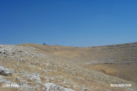
| Location: This site lies 15 km northeast of the city of Sanliurfa; 2.5 km northeast of the village of Karaharabe (Örencik). The survey code of this site is V 52 / 1. |
| Geography and Environment: This site has been named Göbekli Ziyaret or Göbekli Tepe Ziyareti after the graves of saints on the mound. The site; which lies near a steep stream bed; consists of a series of hillocks composed of reddish soil; lying on a limestone ridge oriented northwest-southeast. It can be seen that there are burials on the two highest hillocks. The diameter of the area with these hillocks is 150 m. Although there is a seasonal stream west of the site; there are no water sources in the area and the region is thus not agriculturally productive [Benedict 1980:137; Braidwood-Braidwood 1986:8]. |
| Destruction Details: |