| ©The Archaeological Settlements of Turkey - TAY Project | ||||||
|
|
||||||
Akmakca |
||||||
|
|
||||||
| Ages | Maps | Photos | ||||
| Neolithic |
 |
 |
||||
|
|
||||||
|
Type:
|
Flat Settlement | |||||
|
Altitude:
|
760 m | |||||
|
Diameter:
|
m- Direction: | |||||
|
|
||||||
|
Region:
|
Aegean | |||||
|
Province:
|
Kütahya | |||||
|
District:
|
Gediz | |||||
|
Village:
|
Dayinlar | |||||
|
|
||||||
|
|
||||||
|
|
||||||
|
TAYEx:
|
Visited - 4/7/2004 | |||||
|
|
||||||
|
Registration State:
|
For detailed registration information please refer to Turkish pages. | |||||
 |
||||||
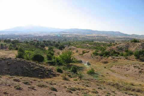
| Location: This site is southwest of the city of Kütahya; east of the town of Simav; 2-3 km southeast of the village of Yeni Gediz. It lies on the sloping ridge at the foot of the village of Old Dayinlar (Dainler) village; which has now been abandoned after the earthquake in 1970; and extends to 150 m left of the Yeni Gediz-Old Dayinlar road. |
| Geography and Environment: The name Akmaca; chosen as the archaeological reference for this open-air site; is the local name for the area and the Akmaca Çesmesi water source immediately to the east. The diameter of the site is 100 m [Efe 1994:573; Efe 1995b:107]. |
| Destruction Details: |